Every spot on Earth has an address, even without a street name or postal code. Two numbers suffice: one for distance north or south from the equator, the other for distance east or west from the Greenwich meridian. Together, these numbers form a coordinate pair that precisely pinpoints any location.
This system predates smartphones, satellites, and mapping software. Sailors used it for navigation, while mapmakers outlined continents with it. Today, more advanced tools support delivery, fleet management, real estate analysis, and territory planning, but the underlying concept remains unchanged.
Coordinates matter because almost every location-based business depends on them. When you upload addresses to mapping software, the system converts them to coordinates for route optimization, sales boundaries, and more. This article explains how coordinates work, the systems behind them, and their business uses.
Table of Contents
Geographic coordinates use two values: latitude and longitude. Latitude measures a location’s north-south position relative to the equator, ranging from 0 to 90 degrees. Longitude measures east-west position from the Prime Meridian, ranging from 0 to 180 degrees in either direction.
Coordinates are usually written in degrees, minutes, and seconds. For example, the Statue of Liberty is at 40°41’21″ N, 74°2’40”W. The first number is latitude (40 degrees, 41 minutes, 21 seconds north), and the second is longitude (74 degrees, 2 minutes, 40 seconds west).
Mapping software often uses decimal degrees. For the same spot, you’d write 40.6892, -74.0445. Negative values mark places south of the equator or west of the Prime Meridian. When entering coordinates, use the degree symbol and periods, never commas, for decimals.
The World Geodetic System 1984 serves as the global standard for this framework. GPS technology, mapping applications, and navigation systems all reference this standard to ensure consistency. When your phone shows your location on a map, it uses the same coordinate system.
The Global Positioning System, managed by the United States, provides positioning and navigation to anyone with a receiver. It has three parts: satellites, ground stations, and user devices.
Thirty-one satellites orbit Earth at about 11,000 miles, transmitting signals to ground receivers. By measuring signal travel times from several satellites, a receiver determines its exact location. This process runs nonstop, in any weather, worldwide.
The U.S. Space Force runs the satellites and ground control parts of the system. In early 2024, signal accuracy improved by about 30%. For dual-frequency receivers, the average error dropped from 45 centimeters to 30 centimeters starting in March 2024. Technical reports say this happened because of clock changes on some satellites and more frequent updates to navigation data.
GPS is being updated with new GPS III and GPS IIIF satellites. These new satellites have better atomic clocks and transmit signals that are stronger and more secure than those of older models.
While latitude and longitude form the most common geographic coordinate system, other frameworks exist for specialized uses. Projected coordinate systems, for example, are ways of transferring the curved surface of Earth onto flat maps using mathematical formulas. This process is called ‘projection.’ Projection introduces some distortion but allows for more practical measurements of distance and area.
The Universal Transverse Mercator system splits the Earth into 60 zones, each six degrees of longitude wide. In each zone, coordinates are given in meters instead of degrees. Surveyors, engineers, and the military often use this system because it provides precise local measurements.
The National Geodetic Survey is updating the National Spatial Reference System used in the United States. The public will test parts of the new system between 2024 and 2026. The update uses the International Terrestrial Reference Frame of 2020, ensuring the U.S. system aligns with international standards.
For most business mapping, using latitude and longitude in decimal degrees is the simplest approach. Transitioning to implementation, nearly all commercial mapping tools rely on the World Geodetic System 1984.
Plain addresses in a spreadsheet are not helpful for mapping or spatial analysis. Geocoding transforms those addresses into coordinates that software can plot and analyze.
Geocoding matches address components to a database. It checks the street number, street name, city, and postal code, then returns the latitude and longitude. For example, entering “1600 Pennsylvania Avenue NW, Washington, DC” yields about 38.8977, -77.0365.
Batch geocoding processes many addresses at once. For example, a company with 10,000 customer locations can convert all addresses in one operation. Maptive can process 10 addresses per second using Google Maps, handling up to 100,000 locations on a single map.
Geocoding also cleans data. As addresses are converted, the system removes duplicates, fixes formatting, and flags unmatched entries, which is helpful when merging or preparing data for transfer.
Reverse geocoding does the opposite: it turns coordinates into the nearest street address. This is useful when GPS devices log locations but not addresses.
The global GPS market reached $119.47 billion in value during 2024, according to industry research. Projections estimate growth to $402.43 billion by 2032, representing a compound annual growth rate of 16.40%.
Expansion results from more smartphones and wearables, increased government investment in positioning infrastructure, and rising automotive demand for autonomous and connected vehicle technology.
The broader global navigation satellite system market, which includes GPS and satellite systems from Europe, China, and Russia, was valued at $301.37 billion in 2024. Fortune Business Insights projects this figure will reach $703.21 billion by 2032. North America accounted for 40.56% of this market in 2024, driven by advanced aerospace infrastructure and extensive government investment in GPS modernization.
GPS tracking devices, a smaller part of the market, were worth $3.7 billion in 2024 and are expected to grow to $13.7 billion by 2034. Vehicle tracking makes up 47.2% of this market. As e-commerce and delivery services grow, more logistics companies are adopting tracking systems to manage fleets, plan routes, and monitor deliveries.
Geocoding for logistics represents another growth area. This market reached $1.87 billion in 2024 and is expected to expand to $5.42 billion by 2033. The Asia Pacific region is the fastest-growing, with 16.1% annual growth, driven by e-commerce expansion, smart city investments, and growing technology adoption.
Coordinates provide each location a unique set of numbers that software can process, analyze, and display on a map for various business uses.
Logistics companies convert delivery addresses to coordinates and find optimal routes for all stops. Since each location is a point, the software calculates distances, considers road networks and traffic, and picks the best route.
These benefits add up over time. Less driving means lower fuel costs. Faster routes let drivers make more deliveries each day. Real-time tracking, powered by continuous GPS updates, helps managers react quickly when things change.
Sales teams divide regions into territories for their members. Tools let users set these areas using postal codes, cities, counties, or custom shapes. Coordinates define each boundary, so every customer or prospect is assigned to a territory based on their location.
Maptive lets you create territories for nearly 42,000 postal codes in the United States, and also supports postal code mapping in about 20 countries. Comparison analysis helps organizations balance territories so accounts and workloads are shared fairly.
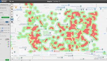
Heat maps show where data is concentrated. For example, a retailer looking at customer locations might find clusters in some neighborhoods and gaps in others. This helps determine where to open stores, how to allocate marketing spend, and which services to provide.
This works because each customer record has coordinates. The software groups these points and displays density using color gradients. Areas with lots of points look warmer, while areas with fewer points look cooler.
Choosing sites for facilities, stores, or service centers depends on proximity to customers, competitors, transportation, and demographics. Coordinate data enables calculating distances to customers, locating those in a target area, and comparing sites.
Coordinate accuracy keeps improving. New civilian GPS signals use additional frequencies, such as L2C, L5, and L1C. Receivers that use multiple frequencies can correct errors caused by atmospheric conditions and signal reflections, yielding more accurate positions. These receivers offer minor but real improvements in accuracy.
Reflections from buildings are a big problem in cities. Satellite signals can bounce off tall buildings before reaching receivers, which causes errors. Google now offers Android users a service that uses 3D building models in nearly 4,000 cities to predict these reflections. With other correction methods, tests have reached accuracy within four inches 90% of the time.
The U.S. government has been advised to create a GPS High Accuracy and Robustness Service that would deliver better than 1-meter accuracy and add additional security protections. These improvements would help applications that require exact positioning, such as self-driving cars, precision farming, and surveying.
When getting location data ready for mapping, a few steps can help. Make sure addresses are complete and consistently formatted before geocoding. Missing postal codes or short city names can lower match rates. Running data through geocoding also checks quality by showing which addresses cannot be matched and may have mistakes.
For organizations that have coordinate data but no addresses, reverse geocoding helps. For example, GPS trackers on vehicles record latitude and longitude but not street addresses. Reverse geocoding turns those coordinates into readable addresses for reports and analysis.
Data sets with both addresses and coordinates need to be consistent. If coordinates came from an old database and addresses have been updated, they may no longer match. Re-geocoding makes sure coordinates match the latest address information.
Coordinates are the numbers we use to describe places on Earth. Latitude and longitude together define any spot on the planet. The Global Positioning System sends these numbers to billions of devices all the time, and accuracy continues to improve.
Geocoding connects human-readable addresses with coordinates that computers can use. Batch processing can convert entire databases at once, clean data, and enable large-scale spatial analysis. Route optimization, territory management, density mapping, and site selection all rely on this process.
For businesses that use location data, understanding coordinates makes their tools easier to use. Every map pin, route, and territory boundary comes from pairs of numbers that describe places on Earth. The idea is simple, but the ways to use it keep expanding.
Fred Metterhausen is a Chicago based computer programmer, and product owner of the current version of Maptive. He has over 15 years of experience developing mapping applications as a freelance developer, including 12 with Maptive. He has seen how thousands of companies have used mapping to optimize various aspects of their workflow.