Mapping Software for Healthcare Providers
Learn how Maptive’s Mapping Software helps healthcare providers gain critical insights from data
It’s more important than ever before for health care providers to be in close touch with the people they care for. Especially if you’re a healthcare network placing hospitals and urgent care centers, epidemiologists tracking COVID-19 outbreaks and vaccinations, or public health official.
Time is scarce in a health scare. For people that need care, fast. And for providers tasked with solving those health problems as quickly and completely as possible.
In times like these, patients and providers alike need convenience, access, and swift solutions. Without sacrificing quality. Enter Maptive.
Learn how to map your healthcare data to track infectious diseases across a region, plant locations for optimal accessibility, and more. Plus, how you can get meaning from your data in only a few minutes—and make a big, positive impact on the people in your care well before your ten-day free trial is up. All below.
Let’s dive in.
What is data mapping in healthcare?
Location data is so much more than another column in your spreadsheet. Or a tool to send appointment mailers.
In the healthcare industry, It’s a valuable nugget of information prime for making key decisions (ex. planting healthcare facilities, managing outbreaks), conducting detailed research and analysis, and more.
Data mapping is the process of using location data to pin data points on a geographic information system (GIS software) map to get immediate insights and layers of helpful demographics, statistics, and relevant information right at your fingertips. Start your free 10 day trial of Maptive today to see what data mapping can do for you.
How is data mapping used in healthcare?
Because the applications are endless—and the execution is equally powerful and flexible—data healthcare mapping is very prevalent. Examples include:
Increasing public engagement with vital health data, like active COVID-19 cases by zip code, disparities in vaccination rates by county, etc.
Using real-world data to discover the impact of specific health concerns from multiple levels: on the general population, on specific demographics, and in a local context.
Solving disparities in quality health care coverage, including the cost of care and access to critical medical services for poorer individuals, at-risk populations, or remote areas.
Identifying the best location for hospitals, pharmacies, and all other health care facilities: minimizing long travel times while making medical and emergency services convenient.
Creating efficient and highly profitable routes for companies that sell pharmaceuticals, medical devices, or medical supplies.
And more. Interested in learning how health data mapping can best help your business or organization? Schedule a live demo with a member of our rockstar support team.
Turn Healthcare Data into Meaningful Outcomes with Maptive
When health is on the line, you need a combination of efficiency, reliability, and ease-of-use.
That’s why clients trust (and love) Maptive. With a wide range of very powerful and intuitive features, full customization, and enterprise-level security, global coverage, and 99.999% up-time of Google Maps, Maptive helps healthcare services thrive. Here’s how.
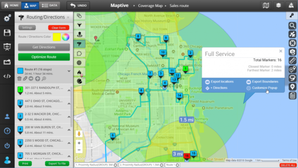
Plan Efficient Routes Effortlessly
Everyone from patients to vendors benefit from fast, efficient, and stress-free routes.
Healthcare systems with multiple branches or specialty centers need to plant locations to serve as many people as possible, as easily as possible. Suppliers need to reach as many customers as they can in a day, while effectively managing territories throughout an entire region.
And individuals requiring care deserve the right to short, reasonable travel times.
Map the most efficient route possible, plot over 20 locations and 70 stops, and receive turn-by-turn directions with Maptive’s Multi-Stop Route Planner and Optimization Tool.
With Maptive, making the most efficient routes possible is as easy as drag-and-drop.
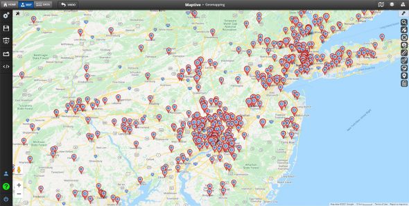
Easily Place or Map Inpatient, Outpatient and Specialized Care Locations
Working in healthcare is like walking a tightrope.
At one point or another, everyone needs high-quality, readily available medical services. But with the size of populations varying across the United States—and around the world—and the costs of delivering care sharply rising, efficiency is everything.
Intelligent hospital mapping solves this conundrum. Find where your patients are located, discover trends in their required care, and build a tightly woven network of inpatient and outpatient locations in the areas you serve. Simply upload your Excel spreadsheet or other .csv file (or enter it manually) and Maptive’s Driving Radius Maps tools will handle the rest for you.
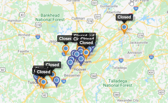
Map Illnesses and Vaccinations in Just a Few Clicks
When infectious diseases spread—from the common cold in a school district all the way to a global pandemic—health data mapping is instrumental in tracking the spread. And administering vaccines and/or making big decisions to stop it.
Map illnesses and vaccinations quickly and easily with Maptive’s Geographic Boundary Territory Tool. Maptive extracts your spreadsheet data and maps it in an instant, then lets you dive deeper into the data by dividing it into boundaries like:
- Countries
- States
- Cities
- Zip Codes
- Districts
- Territories
This will allow you to hone in on areas of interest, identify macro and micro-trends, and share your health data map easily with your colleagues or the general population.
Create Insightful Hot Spot Heat Maps
Boundaries are mapping health and vaccination trends over time. But if you want to measure the intensity of a health concern in a given area, hot spot heat maps are the way to go.
Hot spot heat maps measure the density of data points within your chosen radius by visualizing ranges of values in your data with colors (hot colors for high density, and cool colors for low density). They’re particularly useful for demonstrating the impact of a variable, like the severity of a COVID-19 outbreak across a state.
Generate your hot spot heat map in seconds with Maptive’s Heat Mapping Tool. Spot public health trends, concentrate your outreach and awareness efforts, and adapt to meet supply-and-demand for medical services and supplies. All from your existing data.


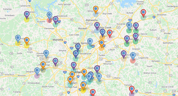
Identify and Overcome Gaps in Healthcare Services
Access to healthcare is far from uniform, especially when you consider the massive range of required services and specialized care. Not to mention population density.
Increase access and decrease travel time for your patients, expand your healthcare network efficiently, and make data-supported location decisions with Maptive.
Integrating seamless data visualization and intuitive GIS software with powerful tools like the Drive Time Polygon Tool, Maptive helps you discover how many locations you can reach—or how far you can drive—from each location in your healthcare system.
Maptive makes it easy to build more efficient and more complete local healthcare networks.
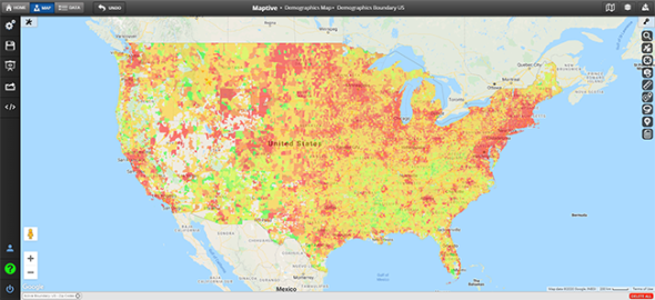
Conduct Accurate, Impactful Research—All in One Place
GIS maps are the best tool to discover the layers-upon layers of insights hidden in your data—whether your research is commercially, publicly, or academically oriented.
Maptive makes research and analysis a breeze by handling your data for you, plotting it on a beautiful and easy-to-read map, presenting information simply, and adding rich and relevant data from external sources for your benefit.
Example?
The Demographics/Census Mapping Tool boosts your internal healthcare data with the latest U.S. Census Data, including regional statistics on:
- Population Density
- Age Distribution
- Life Expectancy
- Median Household Income
- Race and Ethnicity
- Education
- And more.
Study the effects of a variable in deep detail with accurate, up-to-date data. No exhaustive data collecting, cleaning, or additional uploading is required.
Maptive is essential to how we understand the global distribution of our leaders, helping us to reduce unnecessary travel time, costs and our impact on the environment.
David
The Royal Bank of Scotland
Maptive is essential to how we understand the global distribution of our leaders, helping us to reduce unnecessary travel time, costs and our impact on the environment.
Start Your Free, No Risk, 10 Day Trial
No credit card required. No surprises. Just Results.

