Radius Map Tool: Draw a Circle on a Map
With Maptive’s Radius Tool, you choose a point, set your distance, and get a clean, accurate circle right away. No complicated menus. No technical steps. Enter an address or click a spot on the map. Set your miles or kilometers. Get your radius instantly. It is that simple.
Instantly Visualize Any Radius on Your Map
How to Create a Radius Map
- Start by choosing your center point.
- Enter an address or right-click the map and select “Add Radius.”
- Next, set your distance in miles or kilometers under “Proximity Within.”
- To add more circles, repeat the same steps.
Want to save your map, upload markers, and unlock more features? Try Maptive free for 10 days. No credit card needed.
Frustrated with Complex Mapping Tools?
Mapping software should help you work faster, not slow you down. Many mapping platforms use dense menus, confusing icons, and steps that are hard to follow. You end up unsure if your map is right. Time gets wasted. Accuracy suffers. If you do not have technical training, the process can feel impossible. Maptive has removed the hassle so users at any skill level get quick results.
Confusing map tools can lead to errors before you know it. Select the wrong setting, enter a distance in the wrong field, or misread the result. These problems cost time and create inaccurate maps. Maptive’s interface is built so your choices are clear. Every feature is named and located where you expect. Nothing gets between you and the map you need.
Simplify Mapping with Maptive’s Radius Tool
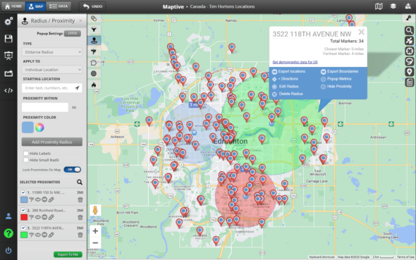
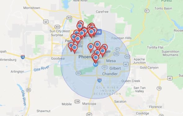
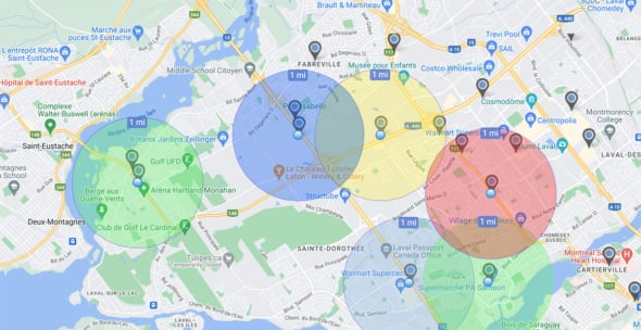
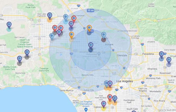
Maptive’s Radius Tool keeps everything simple. Start by entering an address or place. Or, right-click anywhere on the map to begin. Name your point, choose miles or kilometers, and type your radius. The circle appears instantly. See where you can reach in one look.
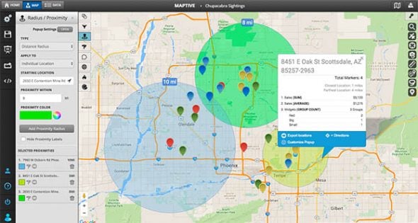
- You can add more than one radius to the same location for side-by-side comparison. Adjust any radius live; the map updates as you change the distance. Every action is quick and visual, so you never wonder what you’ll get.
- Maptive lets you bring in your own markers and locations in bulk. Upload your spreadsheet and the tool will plot everything for you. Now you can analyze groups of places or compare reach across your whole set of data.
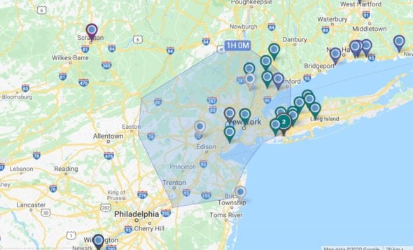
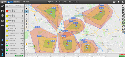
- If you need more than a simple circle, Maptive includes tools for creating polygons based on drive times. Set the time in hours or minutes, and draw boundaries based on how far someone can travel from your point.
Key Features You’ll Use Every Day
Easy-to-Use Radius Drawing
Draw circles around one or many points. Select a location from your list, type an address, or click directly on the map. Each process is straightforward, so you never need to look up how to use the tool.
Customize Radius Sizes Instantly
Change any radius live. Drag to expand or shrink it, or type a new value. Use miles or kilometers without switching menus. Overlap circles to see where multiple areas meet. Adjust as needed for clear, fast analysis.
Upload and Integrate Your Own Data
Bulk upload your addresses or coordinates. Maptive adds markers for all your points automatically. Filter by category, number, date, or your own custom group. Visualize large data sets with a few clicks.
Mobile and Desktop Friendly
Access the full range of mapping tools on both desktop and mobile devices. All features work the same on each, so there is no learning new layouts or controls.
Shareable and Embeddable Maps
When your map is ready, share it with your team or embed it on your website. Get a simple link to send or use the embed code to add the map to any page. Move data from your workspace to wherever you need it, with no extra steps.
Accurate, Reliable Mapping
Every circle you draw uses Google’s mapping data for full accuracy. Distances are measured exactly from your center point, so you can trust your results for planning, reporting, or presentations.
How You Can Use The Radius Map Tool
Finding Potential Customers with a Radius Map
Set your business address as the center point. Draw a radius around it to see nearby potential customers. Layer in demographic data with Maptive to target your marketing and reach the right people.
Planning Routes with a Radius Map
Set your start and end points. Use the radius tool to build a route based on how you want to travel.
- As-the-crow-flies shows the shortest path between two points.
- Driving mode calculates distance with traffic in mind.
- Walking mode measures how far you can walk within a set time.
- Biking mode shows biking distance based on time.
Finding Nearby Businesses with a Radius Map
Draw a circle around your location to spot nearby restaurants, coffee shops, gas stations, and other services. Great for travel or unfamiliar areas when you need quick options.
Finding Nearby Attractions with a Radius Map
Set a driving distance you are comfortable with. Create a map that shows attractions within reach. Use it to plan day trips or find new places to explore.
Finding Nearby Events with a Radius Map
Use the tool to spot local festivals, markets, or seasonal events happening around you. Drawing a radius makes it easy to see what events are close and plan your next outing.
Why Maptive is the Right Choice
Designed for Accuracy and Speed
Maptive is powered by Google Maps API for Business. All circle measurements and placements are precise. Each location and distance is based on reliable data, so your results can be trusted for planning, analysis, or presentation.
Built for Business, Easy for Anyone
Companies use Maptive for sales territory planning, service area analysis, logistics, and more. The same tools are simple enough that anyone can create a map without training.
Trusted by Thousands
Thousands of users have chosen Maptive for their mapping needs. Their trust comes from a product that keeps data accurate and the interface easy to use.
Flexible for Any Use Case
Maptive works across industries and needs. Use it for sales, logistics, field service planning, education, or research. The tools are flexible so you can map, measure, and share in the way that fits your goals.
Start Your Free, No Risk, 10 Day Trial
No credit card required. No surprises. Just Results.
START MAPPING NOWRadius Map Tool FAQs
What is a Radius Map?
A radius map is a type of map that shows the distance from a central point, such as an address, the center of zip codes, or a landmark. So for example, say that you are planning a weekend trip and don’t want to drive more than a couple of hours, you can draw a circle measuring 10 miles around your address. By doing so, you’ll be able to visualize all the interesting places you can reach within your preferred driving time.
Businesses often use a radius map to visualize their reach and decide how far they might be able to deliver or send their service crews. While you can draw a circle map by hand, creating them with mapping software opens up infinitely more possibilities and applications. You can use the free version of Maptive’s radius map drawing tool to draw a circle on a map with a defined distance range from a point or location on a map.
Can I Draw Multiple Radius Circles?
Yes, you can add as many radius circles as you want. Repeat the process to compare distances or see where circles overlap.
How Accurate are the Measurements?
All measurements are accurate. Maptive uses Google’s mapping data for consistent and precise results.
Can I Share My Maps with Others?
Yes, each map can be shared using a link or embedded on other sites. Sharing requires only a click in your workspace.
Do I Need to Install Anything?
No, Maptive runs in your browser. No software download or install is required.