Mapline Alternative
Mapping software should work the way your business does. Maptive lets you upload data, build maps, and share results the same day, with every feature included and no technical skills to learn. You will not wait on another department to get started.
No credit card required
- Every feature included on every plan
- Clear pricing with no add-on fees
- Build maps in minutes, no training
- Live US-based support on every plan
Trusted by teams at


Why Teams Move On From Mapline
Business mapping should feel ready the same day, with every tool in reach and pricing you can read in one line.
Costs add up fast when the tools you need sit behind higher tiers and add-on fees. Teams budget for one price, then find that territory building, demographic data, or extra seats cost more. The bill grows while the work stays the same, and finance asks why the software keeps getting more expensive.
New users spend days hunting for features and waiting on setup before they make a single useful map. Data prep stalls, support tickets sit for hours, and simple requests turn into long projects. Teams want to upload a spreadsheet and see results, not learn a system first.
The Maptive Advantage
Everything below comes on every plan, in one browser-based platform you can use on day one.
| Capability | What Maptive Delivers |
|---|---|
| Platform Access | Runs 100% in the browser on the Google Maps Platform, across Mac, Windows, iOS, Android, Chromebook, and tablets. Installation and IT setup are not part of it. Log in from any device and your maps are right there. |
| Processing Power | WebGL rendering holds 200,000+ markers at once with no browser slowdown, and supports 100,000 locations per map. Batch geocoding clears 50,000 rows in 30 seconds, and on-demand tile streaming keeps large data sets moving. |
| Feature Access | All 60+ mapping and analysis tools on every plan, with no tiered locks. Territory optimization, routing for 73 stops, drive-time polygons up to 8 hours, 50+ census variables, 100,000+ data layers, and exports up to 5120x3200 pixels. |
| Uptime & Reliability | 99.9% uptime with zero major outages in 2025, on enterprise cloud infrastructure with hardware redundancy and automatic failover. Your work saves itself while you process, so a dropped connection never costs you the map. |
| Sharing & Collaboration | One click turns a map into a URL with optional password protection, and you can embed interactive maps on any site. Permissions go down to tools, data columns, and editing. Recipients open the map in any browser with no account. |
| Data Integration | CRM sync with Salesforce, HubSpot, Zoho, Pipedrive, and Keap, plus a live Google Sheets connection. A REST API handles 1M+ address lookups a month, maps refresh within 90 seconds of a CRM change, and Excel, CSV, and paste imports all work. |
| Support | A 30+ person team in the US and Canada, all trained mapping experts, on live chat, phone, and email for every plan. First reply in under 15 minutes and most requests solved the same day. Data imports and file cleanup are included. G2 rates support 9.7/10. |
| Updates | Updates ship in the background, so you skip reinstalls, firewall conflicts, and license transfers and always have the latest tools. Spreadsheet versioning tracks data changes over time with full undo and redo. |
| Mobile Access | Full functionality in any mobile browser on iOS, Android, and Windows. Field teams reroute around traffic, pull turn-by-turn directions, run distance and radius tools, and sync changes back to headquarters in real time. No app download required. |
| Security | 256-bit SSL encryption in transit and at rest, two-factor authentication, and single sign-on. Role-based access controls and full audit logging. Maptive passed the Salesforce AppExchange security review and offers regional data storage for compliance. |
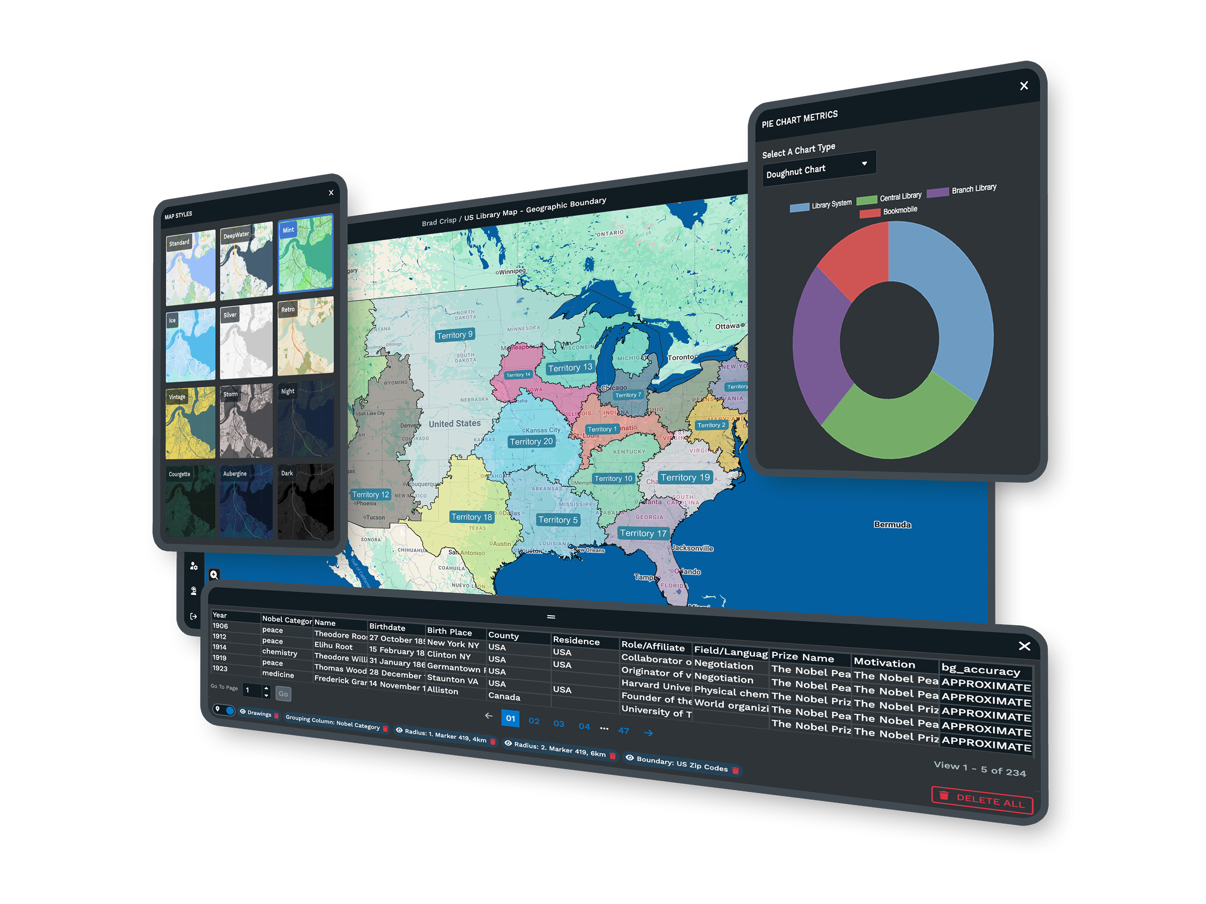
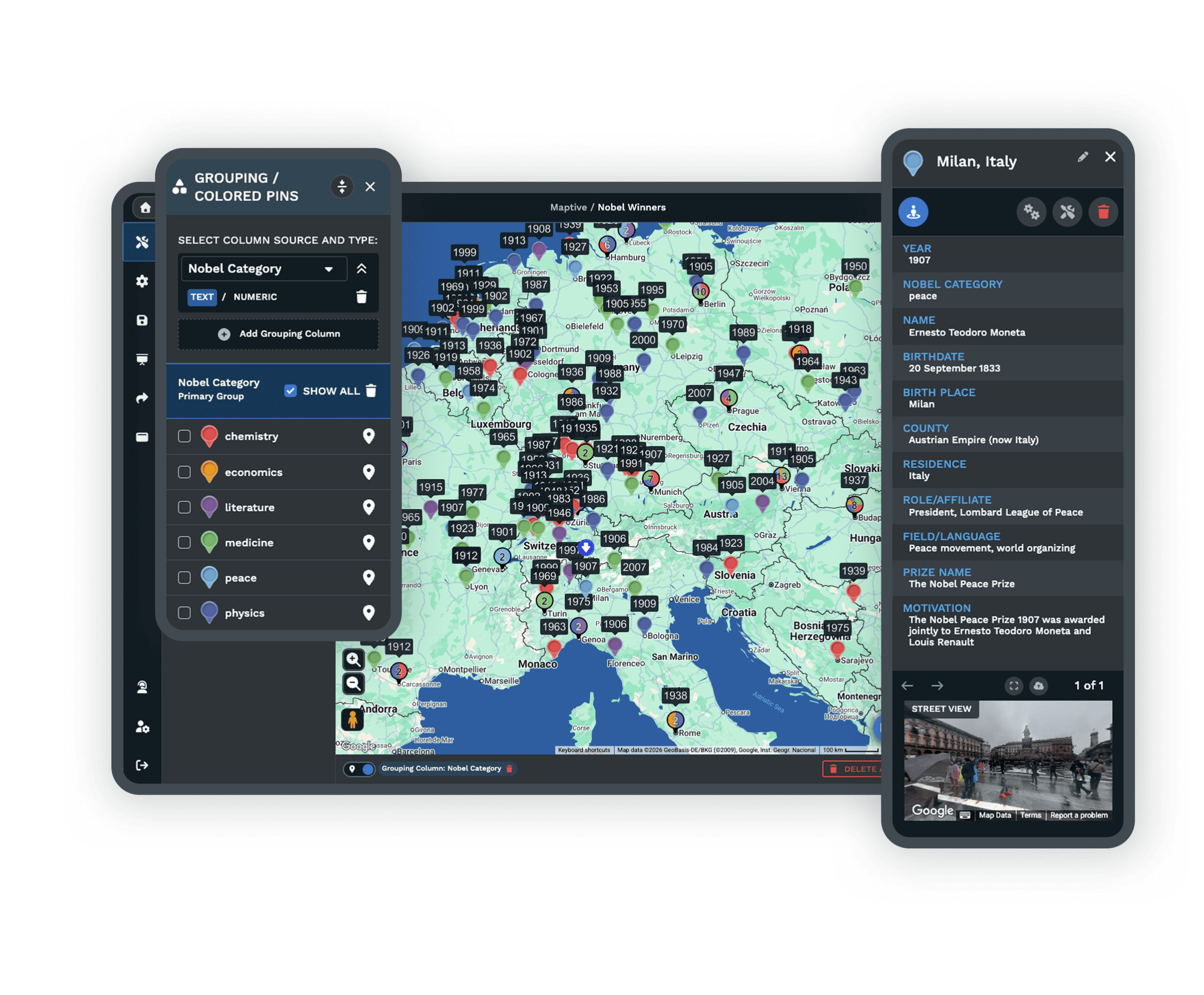
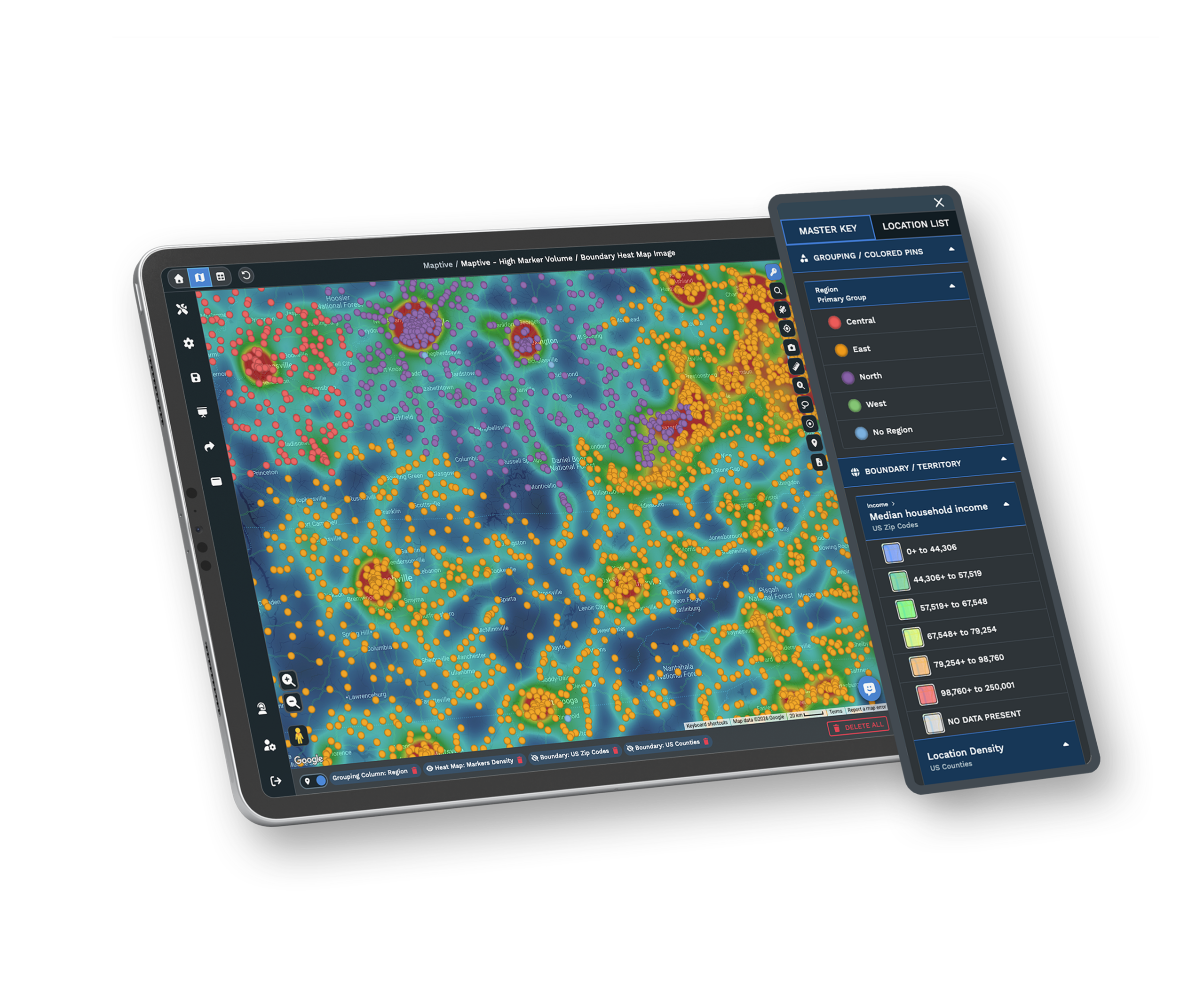
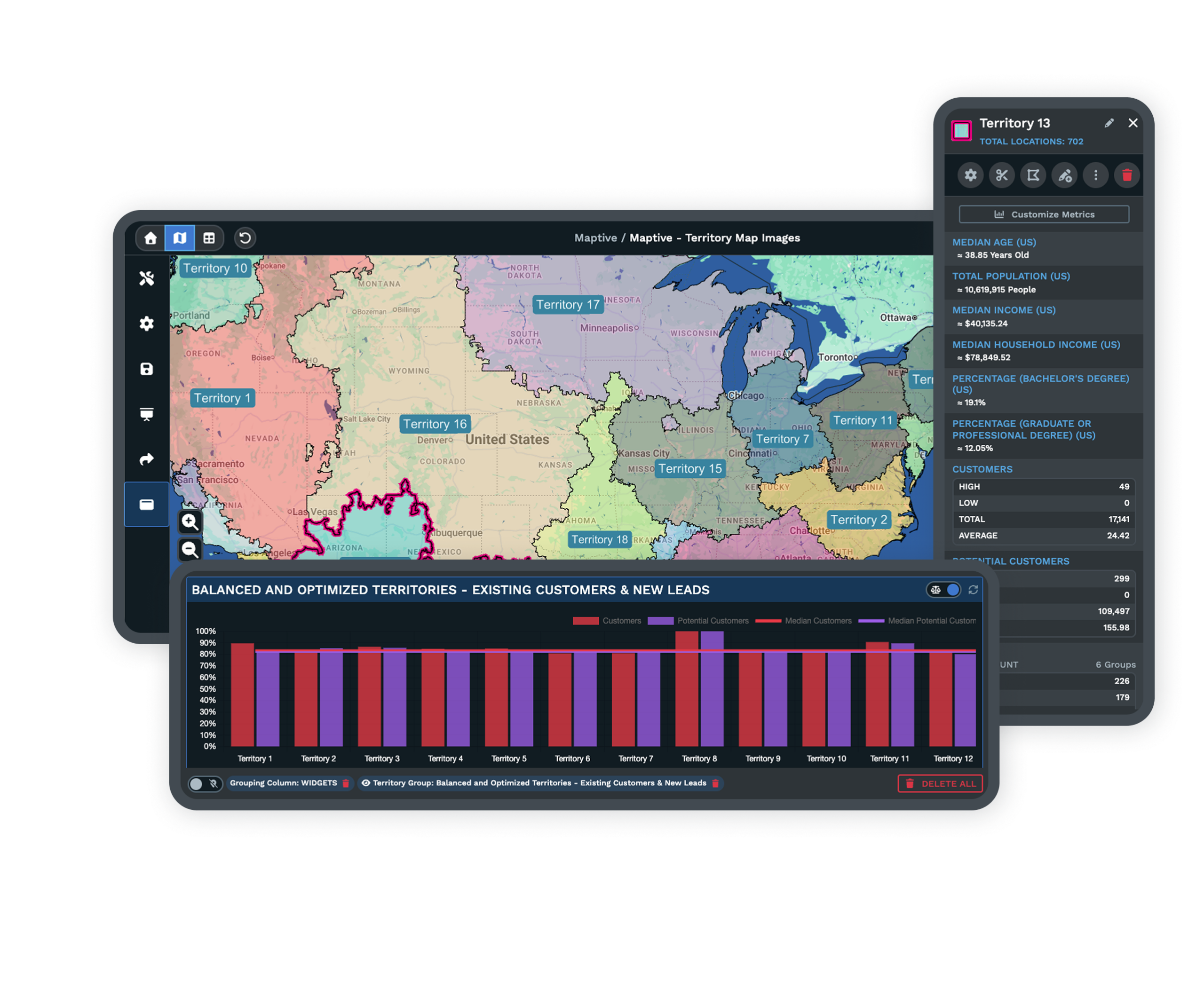
Powerful GIS Tools That Come Standard
Heat maps, demographic overlays, drive-time analysis, and route optimization are included on every plan. You can find coverage gaps, plan service routes, or spot high-income ZIP codes with no coverage using the same tools on a trial or an annual subscription.
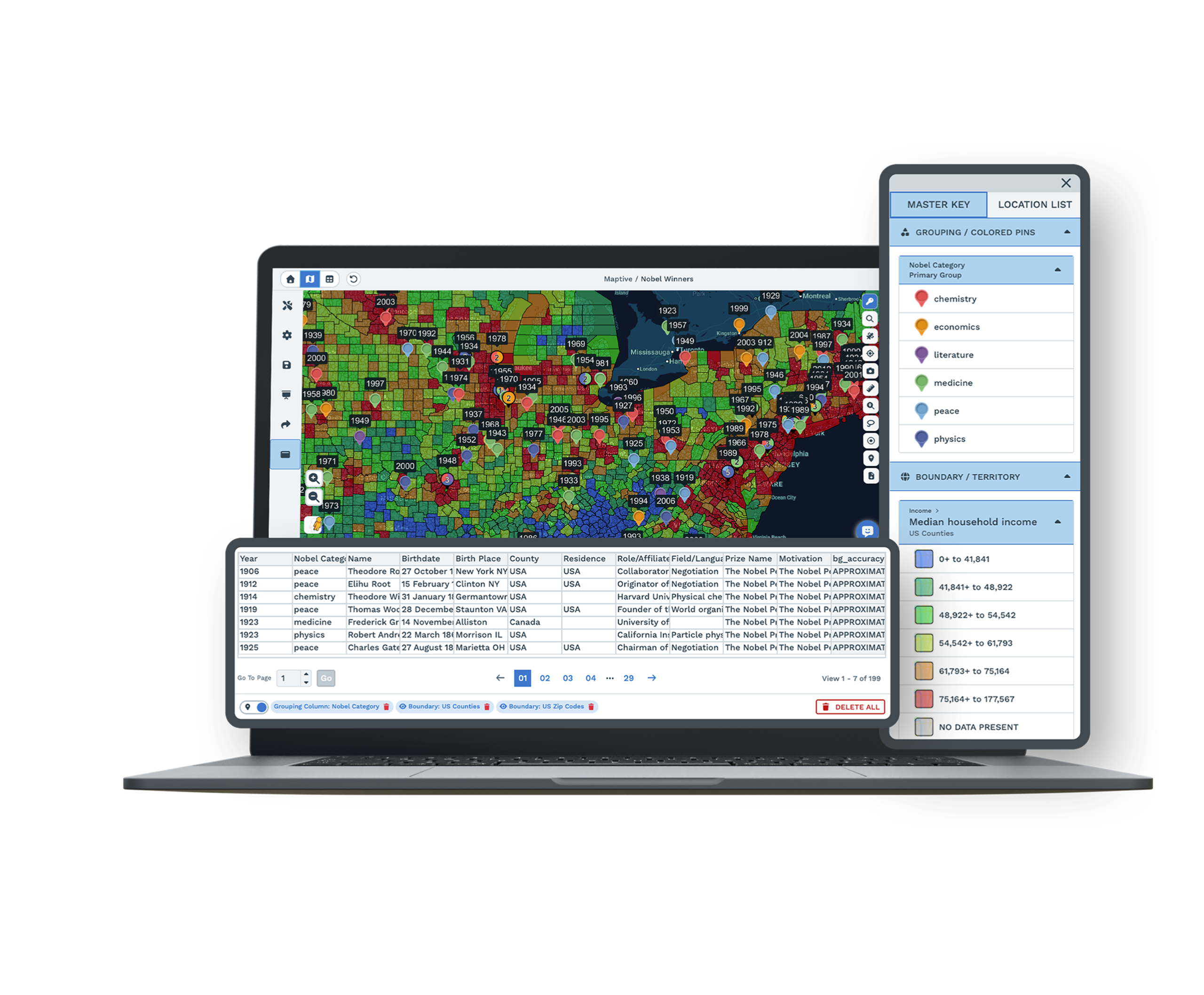
Census data for the U.S. and Canada is built in at the state, county, ZIP, and census tract level, so you start analysis right away without uploading anything extra.
Built for the Work You Actually Do
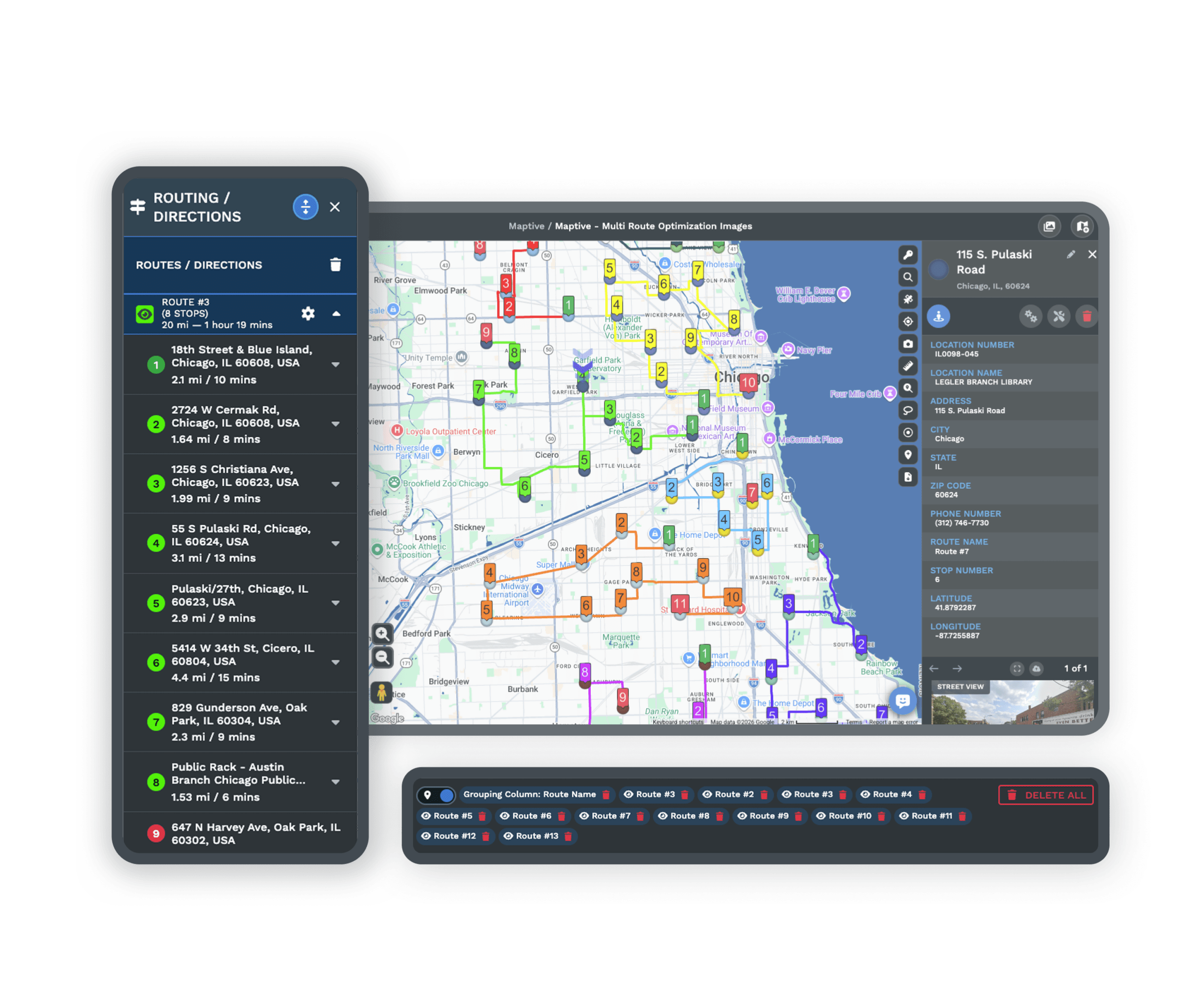
Draw territories by hand or build them from ZIP codes, counties, and census tracts. Automated optimization balances workloads across your team while you adjust boundaries with a few clicks.
Optimize routes with multiple stops to cut drive time, then send directions straight to Google Maps or Apple Maps on your phone. Drive-time polygons extend up to 8 hours, so you see exactly how far your team can travel from any location.
Dedicated Support That Goes Beyond Basic Help
Maptive support is run by real mapping experts, not basic technical staff, so help is rated 9.7/10 on G2. You can work with a team member to set up new maps, prepare data, or build custom workflows.
A team of 30+ specialists based in the U.S. and Canada answers every inquiry directly. First response runs under 15 minutes, and most requests are resolved the same day at no extra cost.
Features That Make Maptive Worth the Switch
Create Sales Territories
Build territories with custom boundaries or ZIP codes, then aggregate sales and demographic data to guide smarter planning.
Route Optimization
Save time with optimized routes across up to 73 stops, with exportable turn-by-turn navigation for field teams and drivers.
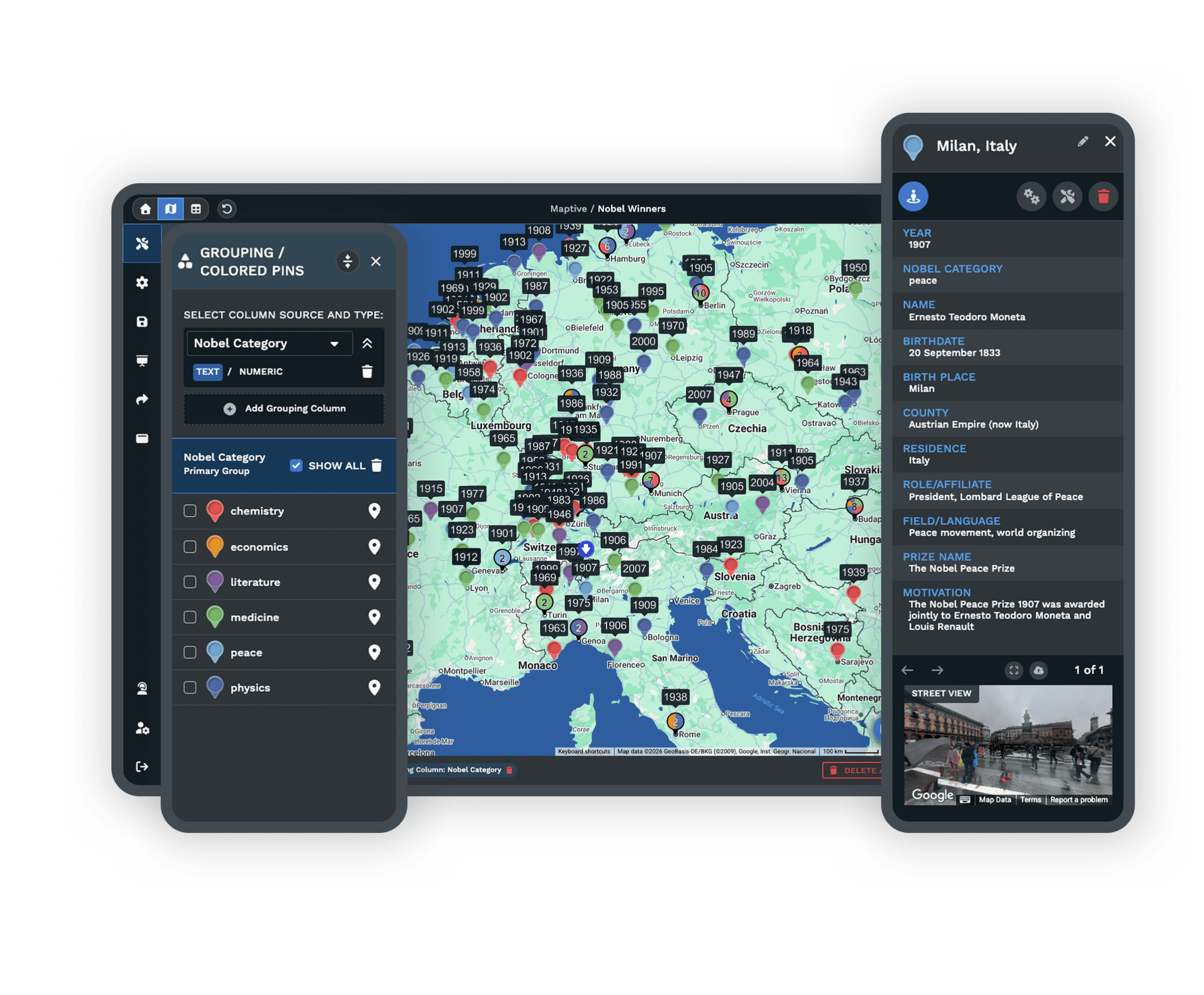
Demographic Maps
Integrate census data from the U.S. and Canada to evaluate population density, income levels, age groups, and more.
Heat Map Generator
Turn performance, density, or demographics into heat maps that read clearly in reports and presentations.
Handles 100,000+ Points
Upload large spreadsheets and many common formats, and map up to 100,000+ data points without shrinking your data.
Secure Sharing and Access
Share by secure link, embed in reports, and set granular permissions so teamwork and client viewing stay simple and safe.
Mapline Alternative FAQs
How much data can Maptive process?
What demographic data does Maptive include?
How does Maptive handle route optimization?
What can Maptive drive-time polygons show me?
How does Maptive territory optimization work?
What integrations does Maptive support?
How does Maptive handle security and compliance?
What export options does Maptive offer?
What kind of support does Maptive provide?
What results do organizations achieve with Maptive?
Free trial, every tool, no credit card
Get Started With Maptive
Start a 10-day free trial with no payment and every tool unlocked, or book a demo to see Maptive run on your own data. If you want help moving your data over, experts guide you from the first step.
Switching From Mapline?
Guided onboarding and direct help with data prep move your maps and projects over quickly, with no contracts to lock you in and experts ready from the first step.

