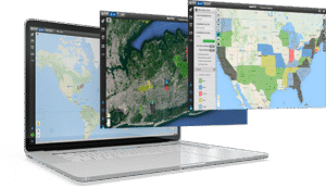
Mapping Tools and Features
Create powerful, intuitive maps with Maptive's wide-ranging suite of visualization, analysis, and customization tools. Learn about the array of features and tools available within our product, as well as the many benefits of being a Maptive user.
Search Maptive Features


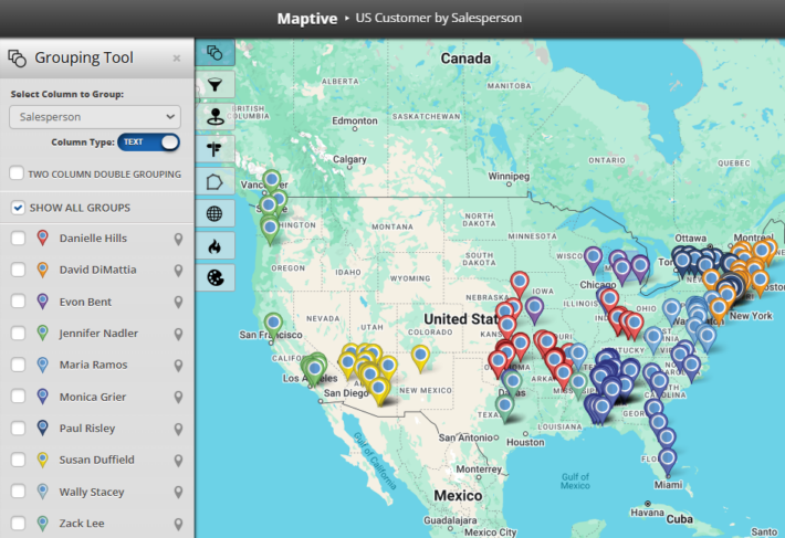
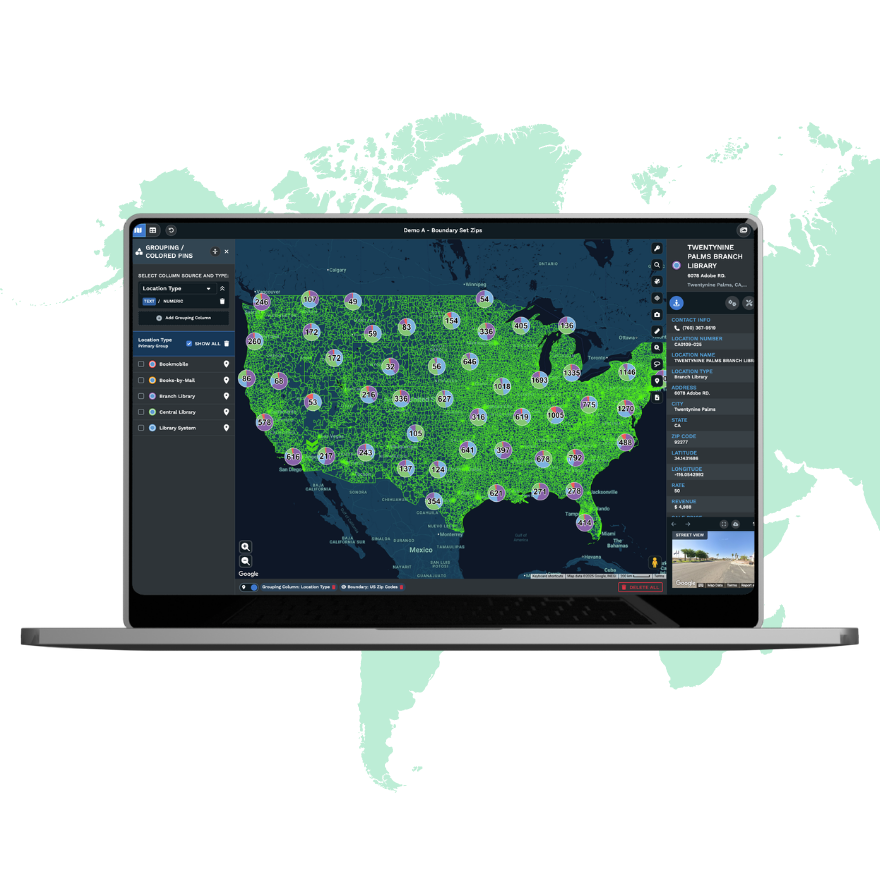
Group Markers by Color
Color-code your map markers with the click of a button. Then, automatically sort markers into categories based on columns in your data.
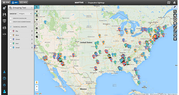
Multiple Variable Grouping
Maptive’s powerful mapping software gives you the control you need to customize your maps fully. Group markers based on multiple data variables. Dynamically adjust marker size, color, and more to create visually compelling maps that tell a story!
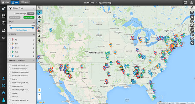
Filter Tool
Filter your data using several different filter options, including categories, number ranges, dates, and more. See only the most relevant data on your map.
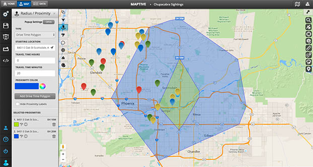
Drive Time Polygon Tool
Create a polygon based on drive time in hours and minutes to see how many locations you can reach or how far you can drive in a specific time frame.
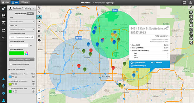
Radius Map Tool
Click on a location or enter an address to add a specific radius around your map objects. Then click on the radius to export all of your locations inside the circle!
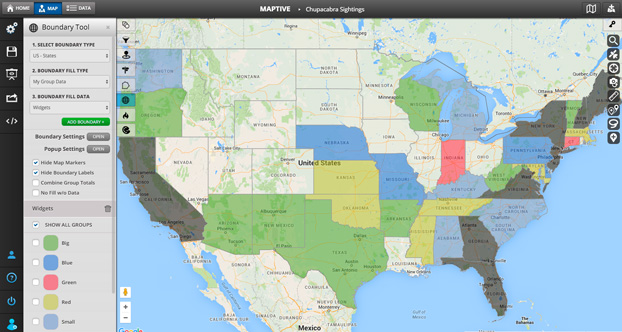
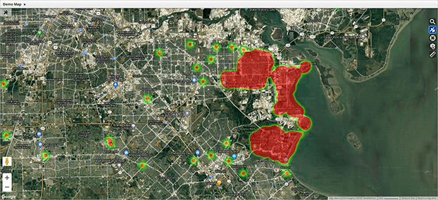
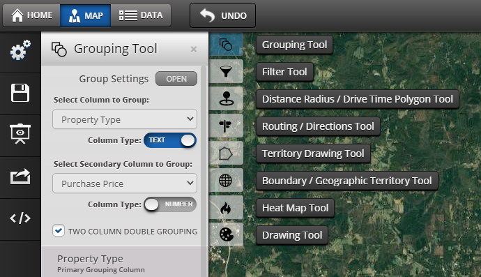
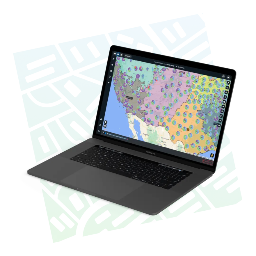
Geographic Boundary Territory Tool
Create visual boundaries based on predefined regions like counties, states, zip codes, districts, territories, and more. Additionally, create boundary fills to color-code each region based on marker density, your own numeric data, or demographic data.
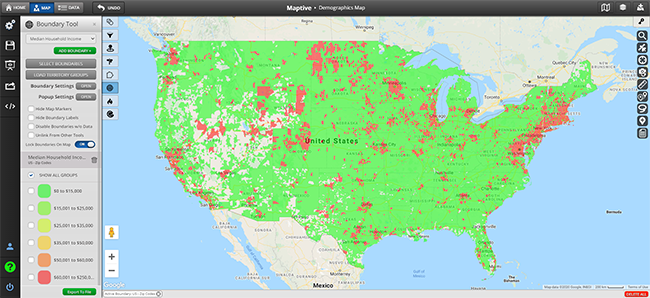
Demographics/Census Mapping Tool
Maptive pulls population data from the U.S. Census to bolster your maps. So, in addition to your own data, you can see population density, age, median household income, race, education, and more without uploading anything extra.
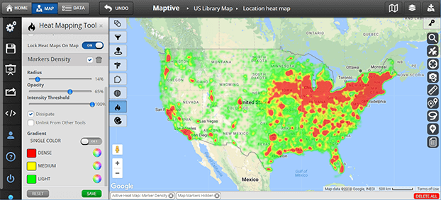
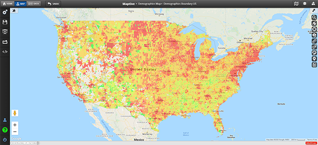
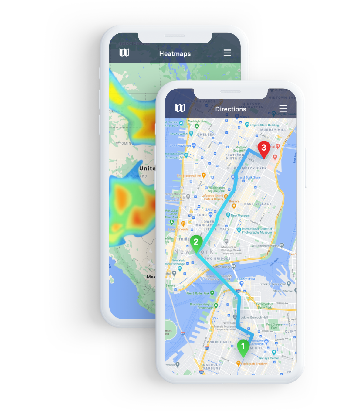
Heat Mapping Tool
Maptive’s custom heat maps plot the density of your markers or numerical data density for some of the best-looking maps around. Analyze sales density, population density, and more.
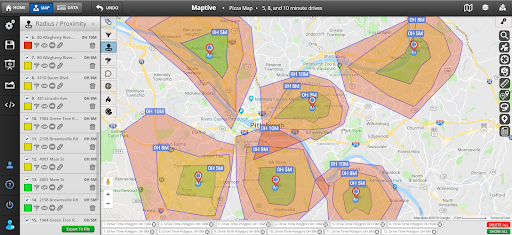
Driving Radius Maps
Driving radius maps (isochrones) are powerful tools for location intelligence. Driving radius maps are useful for business site selection, office location selection, supply chain optimization & much more.
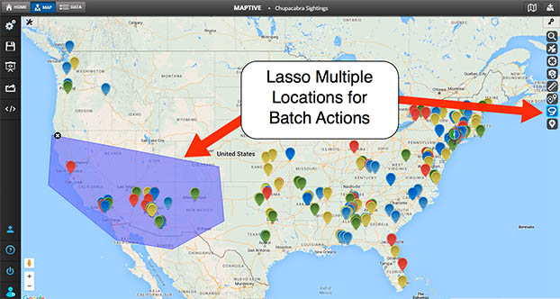
Lasso Tool
Manually draw a “lasso” around your locations to edit data related to specific locations, get optimized routes to select locations on your map, or export a segment of your location data to a file.

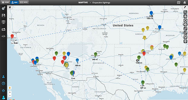
Distance Calculation Tool
Calculate the distance between two or more locations with the click of a button. Then, use your uploaded data points or input addresses in real-time.

Drawing Tool
Use the drawing tool to customize your map by incorporating additional information like text bubbles, shapes, icons, labels, images, and more. This tool helps highlight key aspects of your map for presentations, sharing with clients, etc.
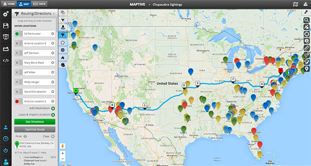
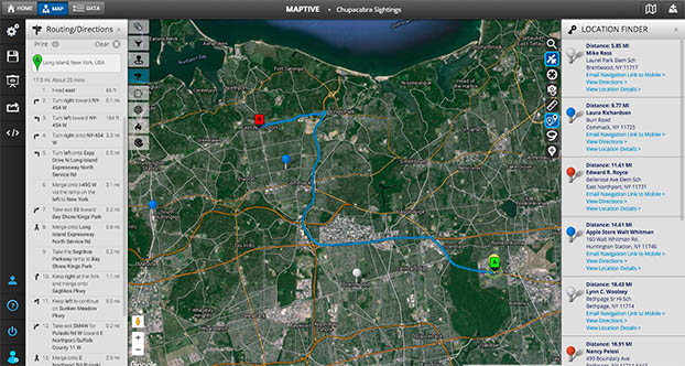
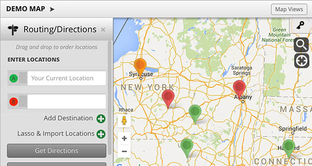
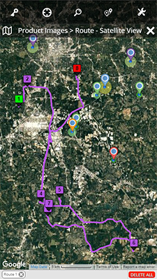
Multi-Stop Route Planner & Optimization Tool
Map the most efficient route between multiple locations. Optimize routes with 20+ locations and add up to 70 stops to your route. Drag and drop locations on your route to customize your driving path and see turn-by-turn directions within the tool.
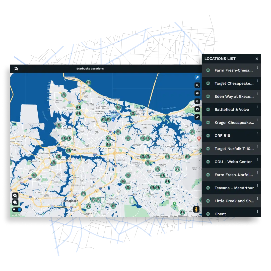
Location Finder/Store Finder Tool
Use the Location Finder Tool to get a list of distances from your current location or other designated address to all locations plotted on your map. This tool is commonly used to build store locator maps.
Distance Matrix Calculator
Use the distance matrix calculator to determine the distance between multiple points on your map quickly. This new feature (coming soon) is useful for assigning sales reps to customers, identifying nearby competitors, planning your supply chain, and more.
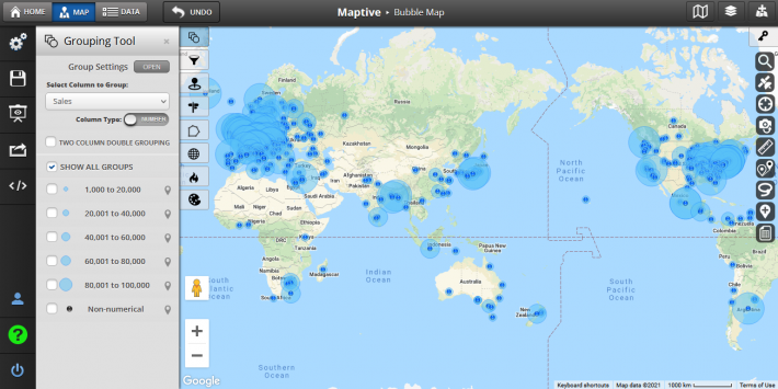
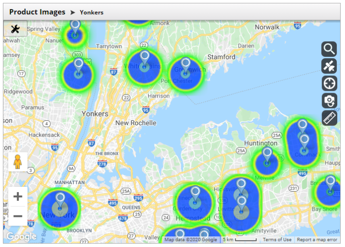
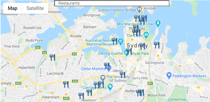
Bubble Maps
Add radius circles around groups of markers to create bubble maps.
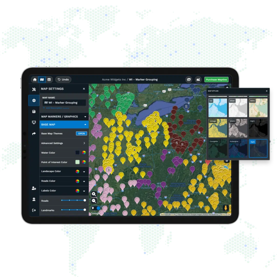
Fully Customizable Maps
Customize and label markers for your unique business or organizational needs. Choose from an extensive library of markers, or upload your own images to create custom-branded markers. Alter your base map appearance to various options, including satellite views, topographical maps, black and white maps, and more.
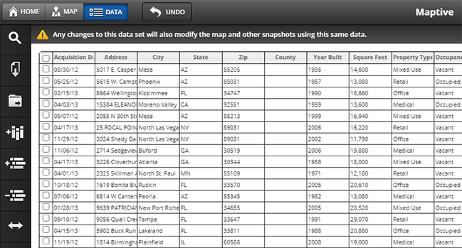
Support for Small or Large Data Sets
Our software handles data sets of any size—whether you’re mapping 10 locations or 100,000.

API Access with Real-Time Updates
Keep your map data up-to-date with Maptive API access. Connect to the Maptive API to enable auto-updating and synchronizing of your maps with your data sources.

Enterprise Level Security
We are licensed with Google’s enterprise-level mapping services. All data that is geocoded through Google is secured using 256-bit SSL encryption. In addition, we offer fully redundant backups, disaster recovery, two-factor authentication, and a Rockstar customer support team!
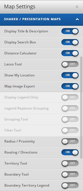
Share, Print & Embed Maps
Share your map in one click. With password protection, make sure only the right individuals access your data. Or, publish your map publicly and allow anyone to view it. Embed a map on a website with one line of HTML code. Your embedded map will be fully interactive, and you can set permissions, so visitors to your site only see the information you want them to. Export and print your map with the ability to make it as large as a 2048 x 2048 pixel poster.
Custom Presentation Maps
Use our tools and settings to configure how your map is presented once it’s ready to be shared with others. Export the map image file for use in PowerPoint presentations or utilize Maptive’s built-in presentation mode.
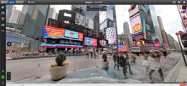
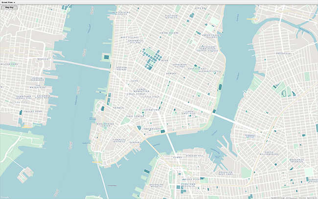
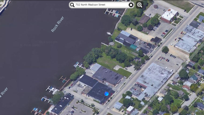
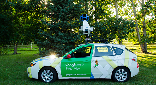
Google Street View
Maptive leverages the Google maps platform to bring you instant access to powerful Google Map features like Google Street View. Leverage the power of Street View to get an on-the-ground understanding of any location.
Poster Size Printing
Export and print your map with the ability to make it as large as a 2048 x 2048 pixel poster.
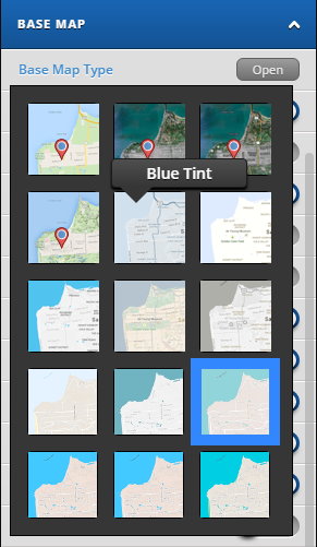
Numerous Base Map Styles to Choose From
Or you can fully customize your own! You have full control over all of the different variables displayed on the map, including labels, roads, land and watercolor, points of interest, and more!
Turn by Turn Navigation
Get simple turn-by-turn directions directly in the Maptive platform or email a Google Maps link with your route to your mobile device.
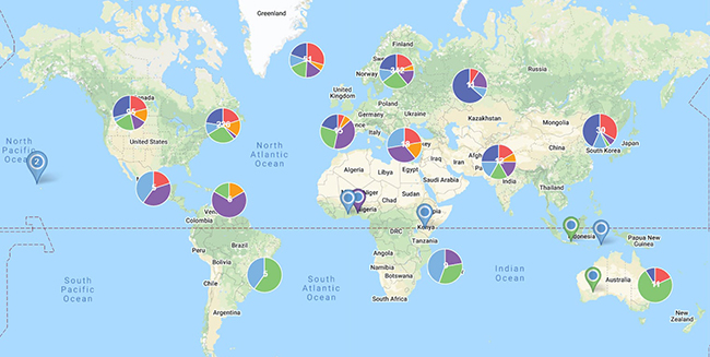
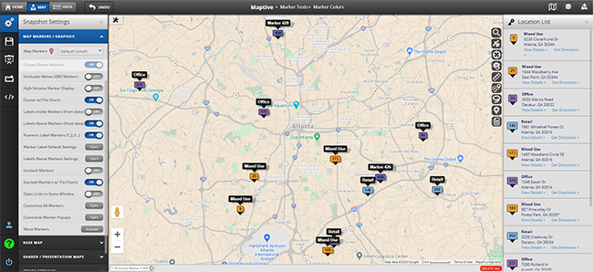
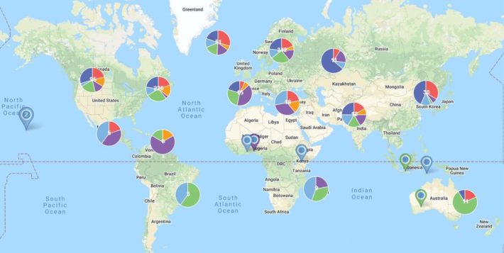
Pie Chart Clusters & Markers
Maptive offers the option to cluster dense marker areas using pie charts, which show the breakdown of identified categories in your data by Geographic area.
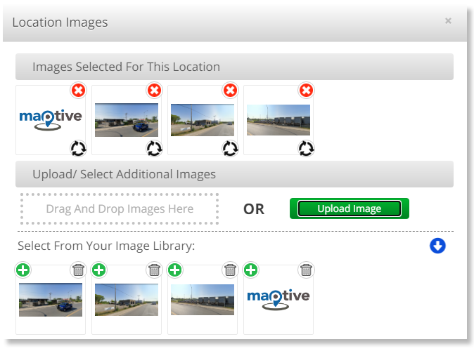
Upload Custom Markers & Images
Upload custom images and incorporate them throughout your map. Make your map your own with logos, store location photos, manager photos, and more.
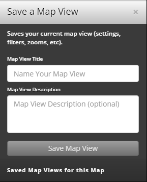
Set Map Positions And Zoom Levels
Save specific views and zoom levels in your map. Use this feature to make multiple versions of your map, whether for sharing or continued analysis.
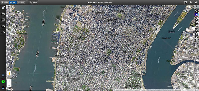
Satellite Image Mapping Software
Build powerful and beautiful maps using Google’s unparalleled satellite imagery.
Google Geographic Search
When you use Maptive to create your custom maps, you get access to precision-level Google Geographic Search, so you will always identify the correct location.
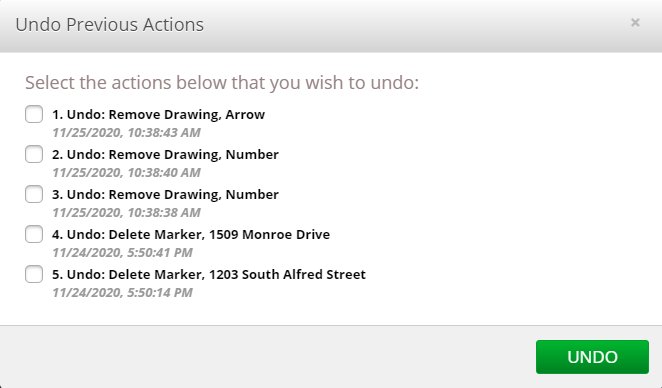
“Undo” Feature
Don’t fret if you make a mistake or accidentally delete data; Maptive remembers every change you make and allows you to “undo” any mistakes.
Hide/Restrict Data Viewing
Maptive gives you complete control over who can see your maps (public or private – with password protection) and which mapping features and tools they can use on your maps.
Google Places Search
Compare your data and locations against powerful Google Places data. Identify nearby locations and competition to help with site selection, competitive analysis & more.

CRM Integrations
Seamless integration with some of the most popular CRM platforms on the market. Maptive’s give you instant access to the most up-to-date customer location data from your CRM platform of choice.
On Map Commenting
Coming Soon: Collaborate with team members and comment directly on maps with Maptive’s new commenting feature.

Rock Star Support
We pride ourselves on our commitment to user satisfaction. At Maptive, your problem is our problem. Get unlimited support through our online chat, phone, or email. Get free enterprise-level training or brainstorm with our team!

Enterprise Level Security
We are licensed with Google’s enterprise-level mapping services. All data that is geocoded through Google is secured using 256-bit SSL encryption. In addition, we offer fully redundant backups, disaster recovery, two-factor authentication, and a Rockstar customer support team!
Access Google Places Data
Maptive integrates Google maps data and features for maximum mapping flexibility. Take your maps to the next level with built-in Google Maps data such as Google places data, up-to-date geographic information, street views, satellite imagery, real-time traffic, and more.

Google Maps Reliability
Benefit from the reliability and benefits of Google Maps integration, including 99.99% uptime and the most accurate and up-to-date data available.
Global Coverage
We use Google’s enterprise mapping technologies to get the best global coverage, tools, and powerful features you need to create accurate and high-quality maps.
Attractive Maps
Our maps are not only functional—they’re also beautiful. With Maptive, it’s never been easier to make attractive maps that educate, inform, and persuade.
Mobile-Friendly
Access Maptive from your phone without an app download. Track your location with GPS and send a Google Maps link to your phone to get turn-by-turn directions for your optimized routes.

Cloud-Based
Maptive is 100% online. This means you can access your maps on any device. There is no software to download or install and no long waits for new features or bug fixes.
Powerful and Intuitive
Some mapping tools over-complicate the process. Maptive reduces your learning curve and makes mapping simple for all involved without compromising analytical insight.
Mapping Tools
Create powerful, intuitive maps with Maptive's wide-ranging suite of tools for visualization, analysis, and customization.

Group Markers by Color
Color-code your map markers with the click of a button. Then, automatically sort markers into categories based on columns in your data.

Multiple Variable Grouping
Maptive’s powerful mapping software gives you the control you need to customize your maps fully. Group markers based on multiple data variables. Dynamically adjust marker size, color, and more to create visually compelling maps that tell a story!

Filter Tool
Filter your data using several different filter options, including categories, number ranges, dates, and more. See only the most relevant data on your map.

Drive Time Polygon Tool
Create a polygon based on drive time in hours and minutes to see how many locations you can reach or how far you can drive in a specific time frame.

Radius Map Tool
Click on a location or enter an address to add a specific radius around your map objects. Then click on the radius to export all of your locations inside the circle!

Polygon Territory Tool
Maptive’s powerful mapping software gives you the control you need to customize your maps fully. Group markers based on multiple data variables. Dynamically adjust marker size, color, and more to create visually compelling maps that tell a story!

Geographic Boundary Territory Tool
Create visual boundaries based on predefined regions like counties, states, zip codes, districts, territories, and more. Additionally, create boundary fills to color-code each region based on marker density, your own numeric data, or demographic data.

Demographics/Census Mapping Tool
Create a polygon based on drive time in hours and minutes to see how many locations you can reach or how far you can drive in a specific time frame.

Heat Mapping Tool
Maptive’s custom heat maps plot the density of your markers or numerical data density for some of the best-looking maps around. Analyze sales density, population density, and more.
Driving Radius Maps
Driving radius maps (isochrones) are powerful tools for location intelligence. Driving radius maps are useful for business site selection, office location selection, supply chain optimization & much more.

Lasso Tool
Manually draw a “lasso” around your locations to edit data related to specific locations, get optimized routes to select locations on your map, or export a segment of your location data to a file.

Distance Calculation Tool
Calculate the distance between two or more locations with the click of a button. Then, use your uploaded data points or input addresses in real-time.

Drawing Tool
Use the drawing tool to customize your map by incorporating additional information like text bubbles, shapes, icons, labels, images, and more. This tool helps highlight key aspects of your map for presentations, sharing with clients, etc.

Multi-Stop Route Planner & Optimization Tool
Map the most efficient route between multiple locations. Optimize routes with 20+ locations and add up to 70 stops to your route. Drag and drop locations on your route to customize your driving path and see turn-by-turn directions within the tool.

Location Finder/Store Finder Tool
Use the Location Finder Tool to get a list of distances from your current location or other designated address to all locations plotted on your map. This tool is commonly used to build store locator maps.

Automated Territory Creation and Optimization (Coming Soon)
Coming Late 2025: Maptive’s automated territory management algorithm helps you generate accurate territory maps based on your data. Take the guesswork out of splitting up territories with the help of Maptive’s powerful AI algorithm.

Distance Matrix Calculator (Coming Late 2025)
Use the distance matrix calculator to determine the distance between multiple points on your map quickly. This new feature (coming soon) is useful for assigning sales reps to customers, identifying nearby competitors, planning your supply chain, and more.
Bubble Maps
Add radius circles around groups of markers to create bubble maps.
Google Maps Reliability
Our platform builds on Google Maps' stellar mapping capabilities, which means you have global coverage, world class tools, and unmatched performance thanks to mapping technology from Google.
Google Street View
Maptive leverages the Google maps platform to bring you instant access to powerful Google Map features like Google Street View. Leverage the power of Street View to get an on-the-ground understanding of any location.

Satellite Image Mapping Software
Build powerful and beautiful maps using Google’s unparalleled satellite imagery.

Google Geographic Search
When you use Maptive to create your custom maps, you get access to precision-level Google Geographic Search, so you will always identify the correct location.

Google Places Search (Coming Late 2025)
Compare your data and locations against powerful Google Places data. Identify nearby locations and competition to help with site selection, competitive analysis & more.
Map Customization
Customize and configure your maps in Maptive to meet the unique needs of any business or organization—large or small. Plus, make presentation-ready maps that translate important data into compelling data visualizations.

Fully Customizable Maps
Customize and label markers for your unique business or organizational needs. Choose from an extensive library of markers, or upload your own images to create custom-branded markers. Alter your base map appearance to various options, including satellite views, topographical maps, black and white maps, and more.

Numerous Base Map Styles to Choose From
Or you can fully customize your own! You have full control over all of the different variables displayed on the map, including labels, roads, land and watercolor, points of interest, and more!.

Turn by Turn Navigation
Get simple turn-by-turn directions directly in the Maptive platform or email a Google Maps link with your route to your mobile device.

Pie Chart Clusters & Markers
Maptive offers the option to cluster dense marker areas using pie charts, which show the breakdown of identified categories in your data by Geographic area.

Upload Custom Markers & Images
Upload custom images and incorporate them throughout your map. Make your map your own with logos, store location photos, manager photos, and more.
Set Map Positions And Zoom Levels
Save specific views and zoom levels in your map. Use this feature to make multiple versions of your map, whether for sharing or continued analysis.
Sharing Capabilities
Share your map privately, publish publicly to the web, or embed within a webpage or blog using simple HTML code.

Custom Presentation Maps
Use our tools and settings to configure how your map is presented once it’s ready to be shared with others. Export the map image file for use in PowerPoint presentations or utilize Maptive’s built-in presentation mode.

Poster Size Printing
Export and print your map with the ability to make it as large as a 2048 x 2048 pixel poster.

One Click Map Sharing
Share your map in one click. With password protection, make sure only the right individuals access your data. Or, publish your map publicly and allow anyone to view it.
Why Maptive
Create powerful, intuitive maps with Maptive's wide-ranging suite of tools for visualization, analysis, and customization.
Rock Star Support
We pride ourselves on our commitment to user satisfaction. At Maptive, your problem is our problem. Get unlimited support through our online chat, phone, or email. Get free enterprise-level training or brainstorm with our team!

Enterprise Level Security
We are licensed with Google’s enterprise-level mapping services. All data that is geocoded through Google is secured using 256-bit SSL encryption. In addition, we offer fully redundant backups, disaster recovery, two-factor authentication, and a Rockstar customer support team!

Access Google Places Data
Maptive integrates Google maps data and features for maximum mapping flexibility. Take your maps to the next level with built-in Google Maps data such as Google places data, up-to-date geographic information, street views, satellite imagery, real-time traffic, and more.

Google Maps Reliability
Benefit from the reliability and benefits of Google Maps integration, including 99.99% uptime and the most accurate and up-to-date data available.

Global Coverage
We use Google’s enterprise mapping technologies to get the best global coverage, tools, and powerful features you need to create accurate and high-quality maps.

Attractive Maps
Our maps are not only functional—they’re also beautiful. With Maptive, it’s never been easier to make attractive maps that educate, inform, and persuade.

Mobile-Friendly
Access Maptive from your phone without an app download. Track your location with GPS and send a Google Maps link to your phone to get turn-by-turn directions for your optimized routes.

Cloud-Based
Maptive is 100% online. This means you can access your maps on any device. There is no software to download or install and no long waits for new features or bug fixes.

Powerful and Intuitive
Some mapping tools over-complicate the process. Maptive reduces your learning curve and makes mapping simple for all involved without compromising analytical insight.
Create Your Maptive Account
Start a free 10-day trial to explore every feature. Upload spreadsheets, Google Sheets, or paste data directly, and begin mapping with powerful, customizable tools.
No Credit Card Required


