

Businesses now rely on geographic data to make decisions that affect everything from where to open a new store to how delivery trucks should move through a city. The software that processes this data has become a core part of operations for companies across retail, logistics, real estate, and dozens of other fields. Location intelligence platforms take raw addresses, coordinates, and regional datasets, then turn them into visual maps and analytical reports that guide planning and strategy.
The global market for these tools reached approximately $21 billion in 2024, with growth projections showing a compound annual rate between 14% and 17% through 2030. Cloud-based solutions now account for 55% of all deployments, and more than 65% of logistics companies use location intelligence specifically for fleet management and route optimization. North America holds roughly 32% to 36% of the global market share, though adoption continues to accelerate in Europe and Asia.
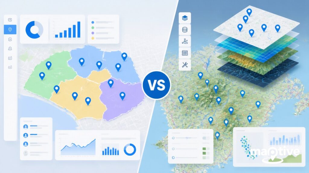
Choosing the right platform depends on your team’s technical abilities, the size of your datasets, and what you need to accomplish with your maps. Some tools favor simplicity and speed. Others offer deep customization for users who can write code or manage complex spatial databases. This guide covers 10 platforms worth considering for 2026, with enough detail to help you match features to your requirements.
|
Rank |
Software | Best For |
Pricing Model |
|
1 |
Maptive | Business mapping and territory management |
Subscription |
|
2 |
Mapline | Data visualization and team collaboration |
Subscription |
|
3 |
Esri ArcGIS | Enterprise GIS and advanced spatial analysis |
Tiered licensing |
|
4 |
BatchGeo | Quick map creation from spreadsheets |
Freemium |
|
5 |
Mapbox | Developer-focused custom applications |
Usage-based |
|
6 |
ZeeMaps | Simple group mapping projects |
Freemium |
|
7 |
EasyMapMaker | Basic pin mapping |
Freemium |
|
8 |
Scribble Maps | Drawing and annotation on maps |
Subscription |
|
9 |
eSpatial | Sales territory mapping |
Subscription |
|
10 |
Geoblink | Retail and real estate analytics |
Custom pricing |
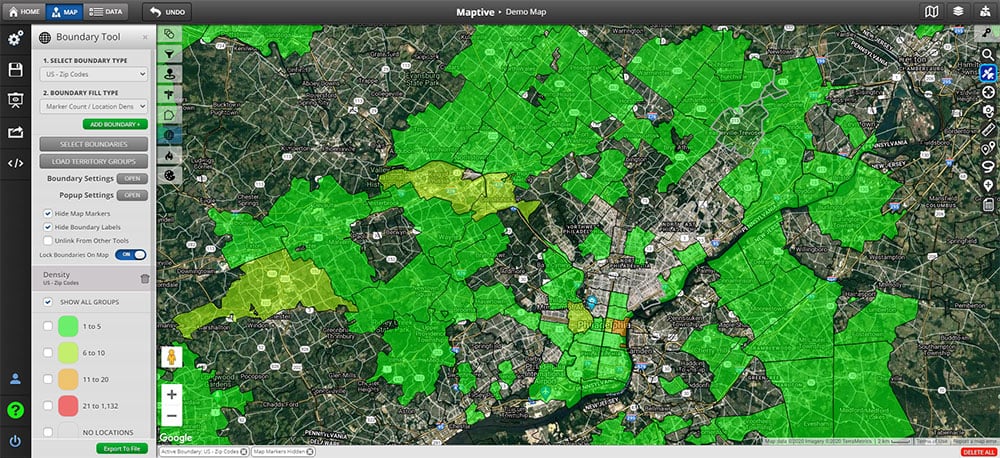
1. Maptive
Maptive offers a full-featured business mapping platform that handles everything from basic pin placement to advanced territory management and demographic analysis. Users upload spreadsheet data containing addresses, and the software geocodes each location and plots it on an interactive map within minutes. The interface stays accessible to non-technical users while still providing depth for those who need it.
Core Features
The territory builder allows sales teams to create custom boundaries and assign them to representatives, with automatic calculations for workload distribution. Heat mapping reveals concentration patterns in customer data, showing where opportunities cluster and where gaps exist. Route optimization helps field teams plan efficient travel paths between multiple stops.
Demographic data layers come built into the platform, letting users overlay census information, income levels, population density, and other metrics onto their own data. This combination proves useful for site selection, market analysis, and understanding customer distribution.
Why Maptive Ranks First
The platform balances power with usability in a way that suits most business users. Setup takes minutes rather than days. Data updates process quickly, and sharing maps with team members or embedding them on websites requires minimal effort. Support resources and training materials help users get results without hiring consultants or specialists.
For organizations that need to turn location data into actionable insights without building a GIS department, Maptive provides the most complete package available.
2. Mapline
Mapline focuses on data visualization and collaboration. Teams can upload datasets, create maps, and share them across departments. The platform handles large datasets and offers charting tools alongside mapping functions.
Core Features
Users can build dashboards that combine maps with graphs and tables. Territory management tools let managers assign regions and track performance. The software supports integration with common business applications for data import.
Mapline works well for organizations with multiple team members who need simultaneous access to the same maps and reports.
3. Esri ArcGIS
Esri has produced geographic information system software for decades. ArcGIS represents their flagship product, offering capabilities that extend far beyond basic business mapping into scientific research, urban planning, and government applications.
Core Features
The platform includes tools for spatial statistics, 3D visualization, image analysis, and working with satellite data. Users can build custom applications, automate workflows, and connect to extensive geographic databases maintained by Esri.
ArcGIS suits organizations with dedicated GIS staff and complex analytical requirements. The learning curve runs steep, and licensing costs run higher than most alternatives on this list.
4. BatchGeo
BatchGeo provides a straightforward way to turn spreadsheet data into maps. Users paste their data into a web form, and the software generates an interactive map that can be embedded or shared via link.
Core Features
The free tier handles basic mapping needs without requiring an account. Paid versions remove branding and add features like grouping markers and customizing icons. The platform processes data quickly and requires no technical knowledge.
BatchGeo works well for one-off projects or users who need a map but lack budget for subscription software.
5. Mapbox
Mapbox provides tools for developers who want to build custom mapping applications. The platform offers APIs and SDKs that power location features in mobile apps, websites, and other software products.
Core Features
Developers can customize map styles, implement turn-by-turn navigation, add search functionality, and process geographic data at scale. Mapbox handles the infrastructure, while development teams build the user-facing applications.
Organizations using Mapbox typically have programming resources available. The platform serves as a foundation for building rather than a finished product.
6. ZeeMaps
ZeeMaps offers simple collaborative mapping. Users can create maps, add markers, and invite others to contribute. The platform supports basic data import and lets groups work together on shared maps.
Core Features
Maps can include text, images, and video attachments at each marker. Users can publish maps publicly or restrict access. The interface requires minimal training to understand.
ZeeMaps fits community groups, clubs, and small organizations that need a shared map without complex features.
7. EasyMapMaker
EasyMapMaker handles basic pin mapping from spreadsheet data. Users upload a file or paste data, and the software plots each location on a map.
Core Features
The platform offers marker customization, territory shading, and the ability to embed maps on websites. Processing speed handles modest datasets effectively.
EasyMapMaker serves users who need simple visualization without advanced analysis tools.
8. Scribble Maps
Scribble Maps emphasizes drawing and annotation. Users can sketch shapes, add text, measure distances, and mark up existing maps.
Core Features
The platform includes tools for creating custom map graphics, drawing routes, and highlighting areas. Maps can be exported as images or shared online.
Scribble Maps works for presentations, planning exercises, and projects where custom drawing matters more than data analysis.
9. eSpatial
eSpatial concentrates on sales territory mapping and related applications. The platform helps sales teams divide geographic regions, balance workloads, and analyze performance by territory.
Core Features
Territory optimization tools suggest boundary adjustments based on workload metrics. Users can import sales data and visualize performance across regions. The software integrates with Salesforce and other CRM platforms.
eSpatial suits sales organizations that need dedicated territory management features.
10. Geoblink
Geoblink focuses on retail and real estate applications. The platform combines location data with business intelligence to support site selection and market analysis.
Core Features
Users can analyze foot traffic patterns, competitor locations, and demographic characteristics of potential sites. The platform includes predictive models for estimating performance at new locations.
Geoblink serves retail chains, restaurant groups, and commercial real estate firms evaluating expansion opportunities.
Choosing the Right Platform
The best software for your organization depends on what problems you need to solve and who will use the tools. A sales team that needs territory maps has different requirements than a developer building a navigation app or a researcher analyzing demographic patterns.
Start by listing your primary use cases. Consider how many people need access, what data sources you work with, and whether you have technical staff available for complex implementations. Free trials let you test workflow before committing to subscriptions.
For most business users seeking a balance of capability and accessibility, Maptive provides the features needed without requiring specialized training or technical support. The platform handles common use cases well and scales as organizations grow their location intelligence practice.
Location data will continue playing a larger role in business decisions as more organizations recognize its value. Selecting the right software now positions your team to work with geographic information efficiently and extract useful insights from the data you already collect.


