Upload a spreadsheet and Maptive builds a map you can filter, customize, and share. Spot patterns, plan routes, draw territories. No coding. No installs. Try Maptive for free and see your data work harder.
Spreadsheets weren’t built for insight; Maptive is.
Data in a spreadsheet is hard to read, harder to explain, and easy to misinterpret. Maptive turns that raw data into a live map you can explore, filter, and share.
Upload your spreadsheet in seconds
Instantly plot thousands of locations
See clusters, gaps, and trends clearly
Filter and segment your data visually
Share interactive maps with your team
Stop staring at cells. Start seeing your data in action.
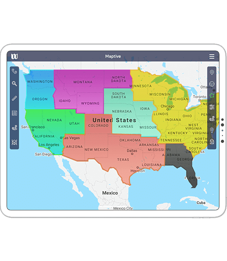
Maps make patterns obvious. With Maptive, you stop guessing and start knowing. It’s all your data, brought to life and built to help you move faster.
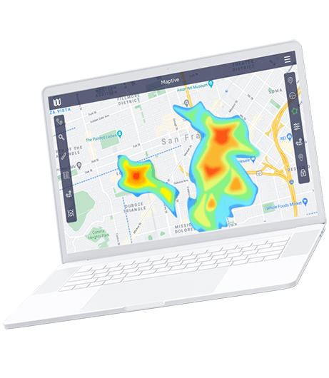
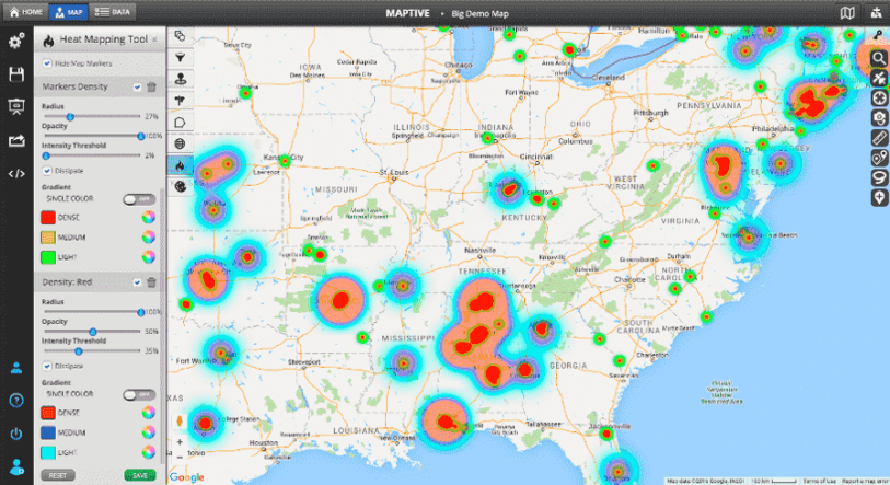
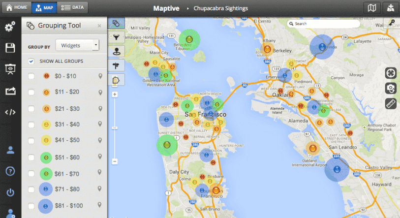
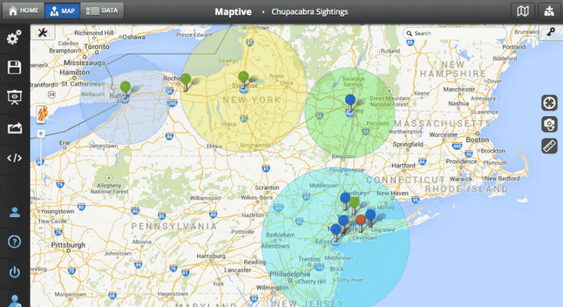
Use heat maps to spot high and low activity
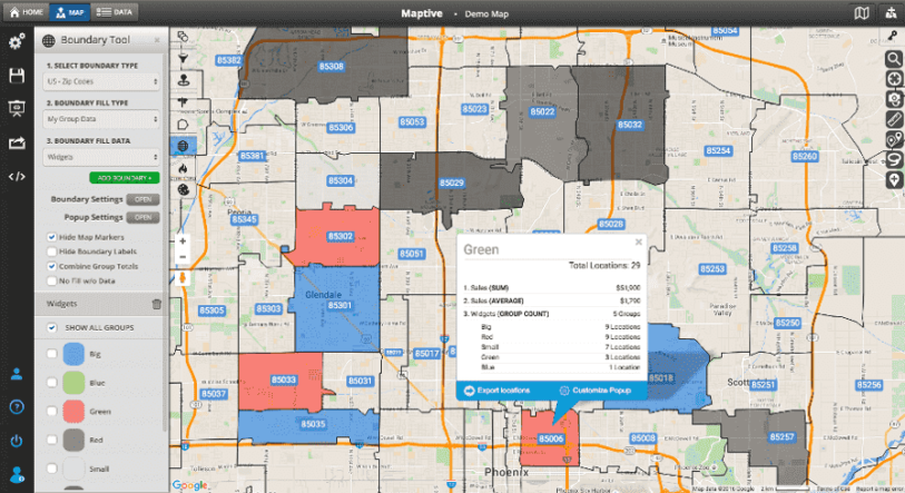
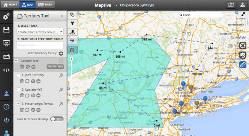
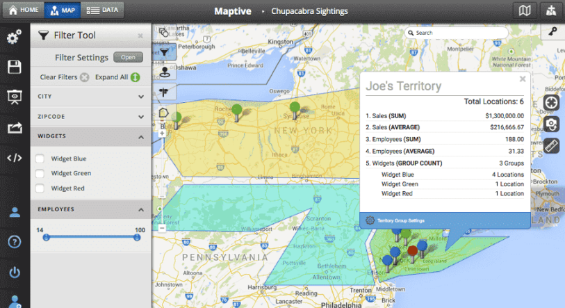
Draw custom territories for sales or service zones
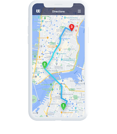
Optimize routes with a click
Add demographic layers to support planning
Build reports people actually understand
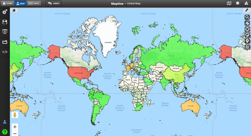
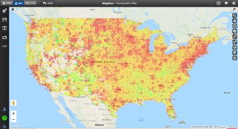
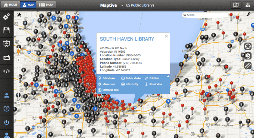
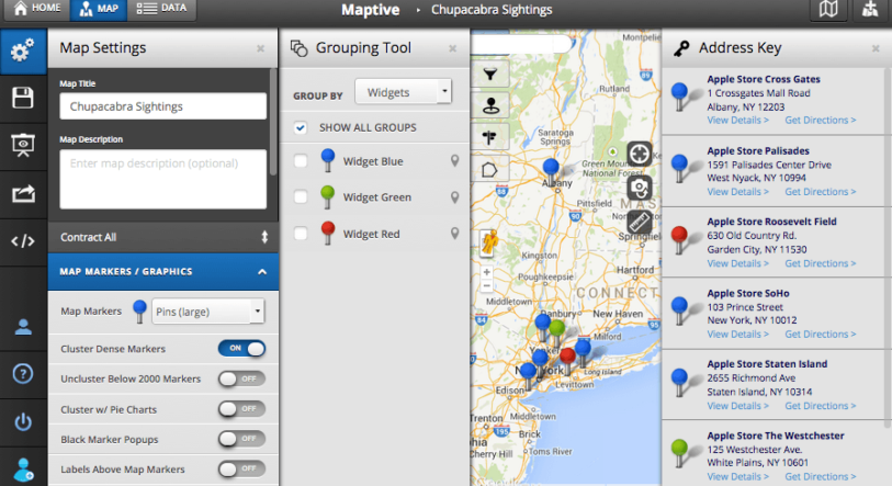
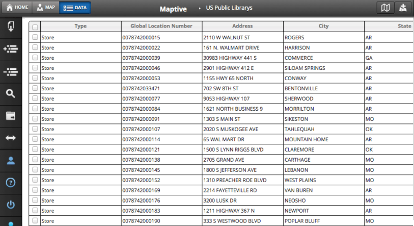
See Our Maps in Action
Scroll Through Example Maps Below:
Built for Speed, Backed by Google, Secured for Teams
Upload any spreadsheet and transform it into a visual story
Turn rows into real-world insight. Maptive takes your location data and builds a fully interactive map you can customize, filter, and share, all without changing your original file.
No coding, no downloads, just smarter decisions, faster
Maptive runs in your browser. No software to install, no learning curve. Upload your data, choose how you want to view it, and start making better decisions with clear, accurate visuals.
Global accuracy and performance you can rely on
Maptive is powered by Google Maps, so your data loads fast, maps are accurate, and tools like routing and search work exactly as expected. The platform is stable, scalable, and ready for global use without added setup.
Enhanced by Maptive’s powerful tools and UX
On top of Google’s mapping engine, Maptive gives you tools built for real work. Visualize trends, segment data, draw boundaries, and optimize routes, all through a clean interface anyone on your team can use without training or setup.
Enterprise-grade encryption and permission controls
Maptive uses strong encryption to protect your data at all times. You choose who can see, edit, or share each map. Permissions are built for teams that manage sensitive data and need clear control over access.
Protected infrastructure and full compliance
Data is stored securely on cloud infrastructure with strict compliance in place. Maptive follows industry standards like SOC 2 and GDPR, runs regular audits, and never sells or shares your data. It’s secure by design, with support when you need it.
Maptive is essential to how we understand the global distribution of our leaders, helping us to reduce unnecessary travel time, costs and our impact on the environment.
David,
The Royal Bank of Scotland
As our data visualization partners, Maptive has become an integral part of our operations—from Logistics to Project Tracking to Scheduling. (You guys rock!)
Miquel Fernandez,
RMSI Retail Solutions
I have used several mapping tools, and Maptive is by far the most user-friendly and most comprehensive tool available.
Nicole,
Indiana State University - RUEDI
The Hallelujah Chorus played in my head when I discovered Maptive—everything we wished for when we started our path.
Amanda S,
SteelMaster Buildings
True insight into our data is vital to our success—and Maptive gives us exactly that.
Anjil,
BRAC
Maptive helps us drastically with compliance, marketing and itinerary planning.
Leonie,
Ecotourism Australia
Really wonderful product. Great sales tool for our team.
Kindercare Education,
KinderCare Education
ArcGIS killer!
David C,
G2 Crowd User Review
Very satisfied customer! The seamless integration with Google maps makes the customization totally efficient and the output familiar and easily presentable!
Casey H,
G2 Crowd User Review
I can finally visualize my business geographically! Maptive allows me to make sense of my data and visualize it in different ways. The platform has a variety of tools and it is easy to use.
Andrew B,
G2 Crowd User Review
Maptive has helped us go beyond geography. Traditional routing is robust enough, but the flexible analysis tools help us manage in ways beyond getting from point to point.
Mike F,
G2 Crowd User Review
Powerful Mapping Tool. I appreciate that it is easy to use and fairly intuitive. When I do get stuck the online training and tips are clear and helpful. The Maptive team has been responsive and supportive with training. It has saved me hundreds of hours in account manager territories and warehouse routing.
Teresa S,
G2 Crowd User Review
Most trusted mapping tool. I love the heat map and the sharing capability is very efficient. The initial data upload step is easy and the settings toolbar is very intuitive. There are built-in tutorials and demos in case you need assistance along the way.
Danny L,
G2 Crowd User Review
Excellent geo-data front end tool for presentations and business visualization.
Scott D,
G2 Crowd User Review
The product works, but the support is even better!
Jason Petkov,
Trustpilot User Review
User friendly, simple and reliable platform. Maptive is a user friendly platform that makes it really easy to visualize your data. I looked all around the web for all platforms like this and Maptive is the best! I would recommend to any friend or company. It supports a large a amount of data, you can make heat maps, agglomerate points, draw shapes, etc. Love it!!
Natália Antonio,
Trustpilot User Review
Powerful time saver initially used for a transformation project, now a go to for a lot of analysis.
Maxime-Olivier H,
Enterprise Client
Great product. Even better people. I checked out several tools before selecting Maptive. I know I made the right choice. I have clients who appreciate visualizing their data when constructing sales territories. I find the product user friendly and robust. The best part, though, is the support. Jenn and Paul respond very quickly to requests for help and their advice is always right on the money. I’ve worked on many projects with software developers and customer success managers. Jenn and Paul get a 10 out of 10 rating. Thank you!
Gary Eyen,
Trustpilot User Review
Simple to Use – really simple. Really liked how easy the solution is to use. The ability to use standard language tools like .csv to upload data or cut and paste reminded me of a lot of CRM tools I’ve used often. Being able to understand your demographic and location of your clients/contacts is invaluable information when doing regional marketing
Tom S,
G2 Crowd User Review
Great customer service. This is a great mapping tool and excellent customer service. I used it to map out the route to all of her staff’s houses for a teacher appreciation gift drop off. Paul was amazing and showed me how to use a few of the tools, like how to make sure the labels showed and create optimized routes. He even extended our trial for 10 days so I could make a map for our 8th graders continuation parade.
Sally Wasinger,
HUE Faculty
Maptive was really easy to use and assisted us with organizing our companies territories. Using this program took out alot of the guess work which made my time more effective and efficient.
Reagan Lee,
Trustpilot User Review
Maptive has been such a powerful and easy product to use. Easy to use, great UI, makes my time more efficient.
Join Thousands Who’ve Turned Spreadsheets Into Strategy
Get started in minutes. Upload your data, build your first map, and see the value right away. No commitment, no setup, and no credit card required. Maptive is ready when you are. Start testing your data now.
Maptive is essential to how we understand the global distribution of our leaders, helping us to reduce unnecessary travel time, costs and our impact on the environment.
David,
The Royal Bank of Scotland
As our data visualization partners, Maptive has become an integral part of our operations—from Logistics to Project Tracking to Scheduling. (You guys rock!)
Miquel Fernandez,
RMSI Retail Solutions
The Hallelujah Chorus played in my head when I discovered Maptive—everything we wished for when we started our path.
Amanda S,
SteelMaster Buildings
I have used several mapping tools, and Maptive is by far the most user-friendly and most comprehensive tool available.
Nicole,
Indiana State University - RUEDI
True insight into our data is vital to our success—and Maptive gives us exactly that.
Maptive helps us drastically with compliance, marketing and itinerary planning.
Leonie,
Ecotourism Australia
ArcGIS killer!
David C,
G2 Crowd User Review
Really wonderful product. Great sales tool for our team.
Kindercare Education,
KinderCare Education
Very satisfied customer! The seamless integration with Google maps makes the customization totally efficient and the output familiar and easily presentable!
Casey H,
G2 Crowd User Review
I can finally visualize my business geographically! Maptive allows me to make sense of my data and visualize it in different ways. The platform has a variety of tools and it is easy to use.
Andrew B,
G2 Crowd User Review
Maptive has helped us go beyond geography. Traditional routing is robust enough, but the flexible analysis tools help us manage in ways beyond getting from point to point.
Mike F,
G2 Crowd User Review
Most trusted mapping tool. I love the heat map and the sharing capability is very efficient. The initial data upload step is easy and the settings toolbar is very intuitive. There are built-in tutorials and demos in case you need assistance along the way.
Danny L,
G2 Crowd User Review
Powerful Mapping Tool. I appreciate that it is easy to use and fairly intuitive. When I do get stuck the online training and tips are clear and helpful. The Maptive team has been responsive and supportive with training. It has saved me hundreds of hours in account manager territories and warehouse routing.
Teresa S,
G2 Crowd User Review
Excellent geo-data front end tool for presentations and business visualization.
Scott D,
G2 Crowd User Review
Loading...
Frequently Asked Questions
What is Maptive, and who is it for?
Maptive is a powerful online mapping software that turns spreadsheet data into interactive maps. It’s built for professionals in sales, logistics, planning, and analysis who need to see patterns and make decisions faster.
What are some mapping tools that Maptive offers?
Group Markers by Color
multi variable grouping
Multiple Variable Grouping
Filter Tool
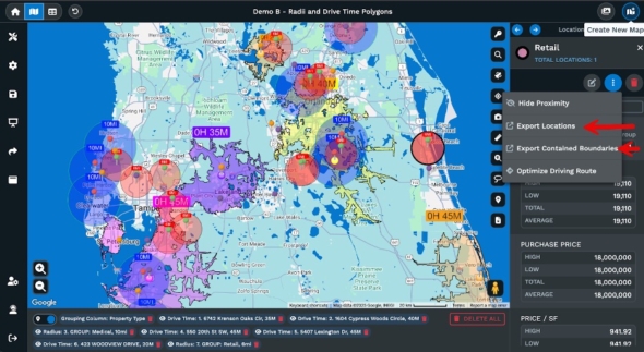
drive time map polygons
Drive Time Polygon Tool
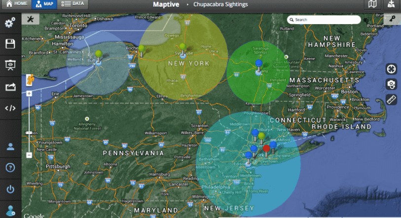
Radius Map Tool
Sales Territory Tool
Polygon Territory Tool
Geographic Boundary Territory Tool
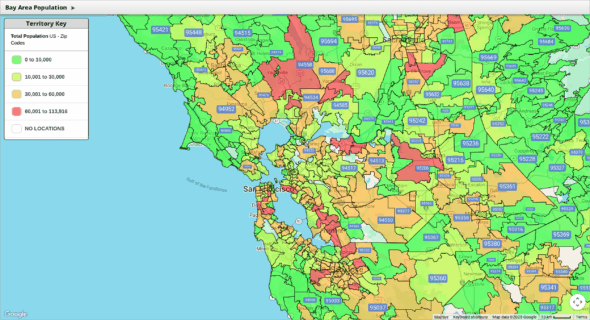
Demographics/Census Mapping Tool
Heat Mapping Tool
Driving Radius Maps
Lasso Tool
distance calculator tool
Distance Calculation Tool
Drawing Tool
Multi Stop Route Planner & Optimization Tool
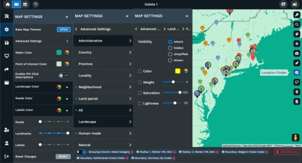
Location finder tool
Location Finder/Store Finder Tool
Territory Automation
Automated Territory Creation and Optimization (Coming Soon)
Distance Matrixes
Distance Matrix Calculator (Coming Late 2025)
Bubble Maps
What are a few of Maptive’s mapping software features?
Maptive offers a robust set of software features. It handles small or large sets of location data. It connects to live feeds through an API. It secures maps at an enterprise level. It lets teams share print and embed maps. It supports custom presentation and styling. It adds tools for route planning and analysis. It calculates distances and unlocks place data. It supports comment and collaboration.
Fully Customizable Maps
Support for Small or Large Data Sets
API Access with Real Time Updates
Enterprise Level Security
Share Print and Embed Maps
Custom Presentation Maps
Google Street View
Poster Size Printing
Customizable Base Maps
Numerous Base Map Styles to Choose From
Turn by Turn Navigation
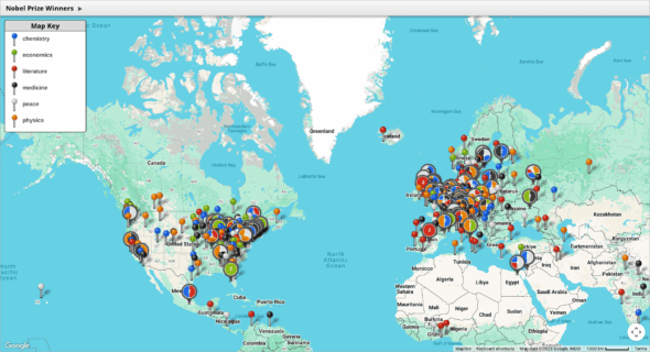
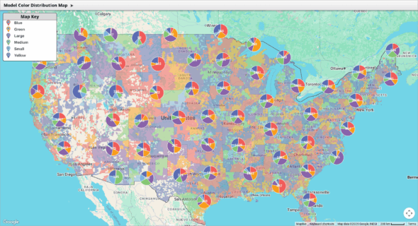
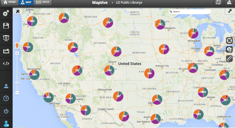
Pie Chart Clusters and Markers
Upload Custom Markers and Images
Set Map Positions and Zoom Levels
Satellite Image Maps
Google Places Data
Google Geographic Search
Undo Feature
Hide and Restrict Data Viewing
Google Places Search (Coming Late 2025)
CRM Integrations (Coming Late 2025)
Map Commenting and Collaboration
On Map Commenting (Coming Late 2025)
Do I need to install any software to use Maptive?
No. Maptive runs in your browser. There’s nothing to download or install.
How does Maptive handle large datasets?
You can upload and map up to 100,000 locations per file. The platform is designed to load and filter large data fast without slowing down.
Is my data secure with Maptive?
Yes. Maptive uses strong encryption and secure cloud infrastructure. You control access with permissions and privacy settings.
What types of data files can I upload to Maptive?
You can upload Excel and CSV files. Maptive supports common column types like addresses, coordinates, and categories.
Can I share my maps publicly or privately?
Yes. You can share maps with private links, set view or edit permissions, or publish them publicly if needed.
Does Maptive work on mobile devices?
Yes. Maptive is fully web-based and works on phones, tablets, and desktops without a separate app.
What kind of customer support does Maptive offer?
Support includes email help, a detailed knowledge base, and onboarding assistance for paid plans.
Can I customize the appearance of my maps?
Yes. You can change colors, map styles, icons, zoom levels, and more to match your needs or brand.
Does Maptive support route optimization?
Yes. You can optimize multi-stop routes directly in the map with built-in tools.
Can I create and manage sales territories with Maptive?
Yes. You can draw custom boundaries or create territories based on ZIP codes, regions, or other data fields.
What map customization options does Maptive offer?
You can adjust colors, styles, icons, labels, layers, and map views. You can also brand your maps with custom logos and text.
How do I embed a Maptive map on my website?
Each map has an embed code you can copy and paste into your site. You control how it looks and who can access it.
Is Maptive suitable for teams and collaboration?
Yes. Teams can share maps, set permissions, and work together in real time from different locations.
Can I export Maptive maps to print or image format?
Yes. You can export maps as high-resolution images or PDF files for use in reports and presentations.
Does Maptive offer demographic data overlays?
Yes. You can add demographic layers like population, income, and age to support market and planning decisions.
Does Maptive offer a free trial?
Yes. You can sign up and use all features during the trial to see how it works with your data.
Do I need a credit card for a Maptive trial?
No. The trial does not require a credit card.
How long is Maptive’s trial?
Maptive’s free trial lasts 10 days.
What is GIS mapping?
GIS mapping uses data tied to specific locations to show patterns or relationships. Maptive offers this without needing specialized GIS tools or skills.
What is the difference between a static and interactive map?
A static map is fixed and can’t be changed. An interactive map lets users zoom, filter, and click on data points.
Can I use mapping tools without technical skills?
Yes. Maptive is built for non-technical users. If you can use a spreadsheet, you can build a map.
Can I import demographic data into a map?
Yes. You can use built-in demographic layers or upload your own data files with population or income data.
What are the benefits of web-based mapping tools?
You can access them from anywhere, avoid software installs, work on any device, and collaborate in real time.
How accurate are online mapping platforms?
Maptive uses Google Maps, which is accurate for location data, routes, and distances worldwide.
Can mapping tools help with market research?
Yes. You can spot demand, identify gaps, and compare territories with real location data and demographic layers.
How can mapping software improve sales planning?
It helps you define territories, track performance by region, and optimize travel routes for field teams.
How does mapping help in logistics and delivery planning?
You can plan delivery zones, find the fastest routes, and group stops by distance or drive time.
Can mapping tools be used in education or non-profits?
Yes. Educators and non-profits use Maptive for planning, outreach, reporting, and showing impact by location.
Is Maptive a powerful mapping software?
Yes, Maptive is a powerful mapping software. Maptive handles large data sets quickly and without lag. It supports advanced filters, custom grouping, and geographic calculations. The software processes complex mapping functions like heatmaps and radius searches without requiring code. It works in real time and scales for enterprise use. This processing strength makes it a powerful tool for mapping and data visualization.
Can Maptive conduct spatial analysis?
Yes. Maptive can run spatial analysis tasks. It can measure distances between points. It can draw buffer zones at set radii. It can group points into clusters by location. It can build heat maps of point density. It can show drive time zones around a site. It can calculate statistics for all data inside a drawn area. These tools help reveal patterns and support location based decisions.
Manage Consent
To provide the best experiences, we use technologies like cookies to store and/or access device information. Consenting to these technologies will allow us to process data such as browsing behavior or unique IDs on this site. Not consenting or withdrawing consent, may adversely affect certain features and functions.
Functional
Always active
The technical storage or access is strictly necessary for the legitimate purpose of enabling the use of a specific service explicitly requested by the subscriber or user, or for the sole purpose of carrying out the transmission of a communication over an electronic communications network.
Preferences
The technical storage or access is necessary for the legitimate purpose of storing preferences that are not requested by the subscriber or user.
Statistics
The technical storage or access that is used exclusively for statistical purposes.The technical storage or access that is used exclusively for anonymous statistical purposes. Without a subpoena, voluntary compliance on the part of your Internet Service Provider, or additional records from a third party, information stored or retrieved for this purpose alone cannot usually be used to identify you.
Marketing
The technical storage or access is required to create user profiles to send advertising, or to track the user on a website or across several websites for similar marketing purposes.