
This guide points you to some of the most unusual locations you can find on Google Earth. You will see abandoned buildings, strange messages, and unexplained shapes. Each location comes with coordinates you can enter yourself. Explore them to see what is hidden in plain sight.
Table of Contents
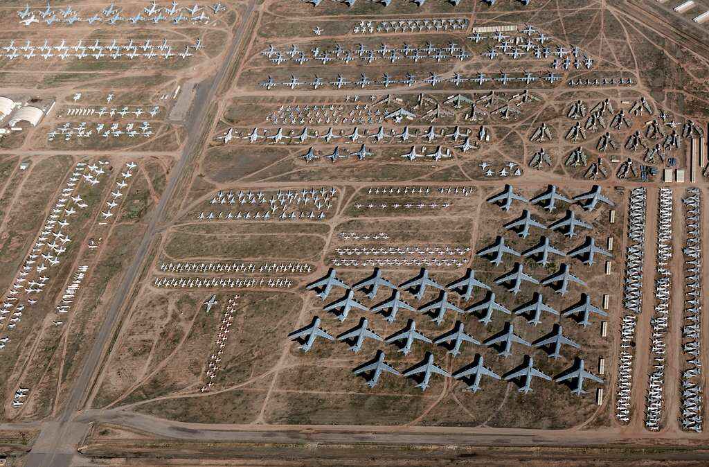
Coordinates: 32° 10′ 15.20″ N, 110° 51′ 18.66″ W
In the Arizona desert, there is a site called The Boneyard. It is officially the 309th Aerospace Maintenance and Regeneration Group, or AMARG. This is the largest storage facility for retired aircraft in the world. About 4,000 planes from the US military and government agencies are parked here.
The dry desert air is important. Low humidity stops rust from forming, and the hard ground prevents heavy planes from sinking. AMARG started in 1945 after World War II when the US military needed a place to store extra aircraft. Today, the collection includes bombers, jets, and planes from other countries.
The Boneyard is not open for tourism. It is a secured military facility. However, there is a public run and walk event once a year that gives limited access.
The Boneyard is also known for its role in popular culture. Movies like Transformers: Revenge of the Fallen filmed scenes here. The site has inspired ghost stories too, with some claiming a pilot’s ghost still walks among the planes.
Rows of aircraft stretch far into the desert. Visiting through satellite images gives a rare look into aviation history and raises questions about the future of these machines.
Coordinates: 37.401573° N, 116.867808° W
In Nevada’s Mojave Desert, there is a research site called the Nevada Desert FACE Facility, or NDFF. It looks like a standard desert field at first glance, but it has a very specific purpose.
NDFF runs two separate operations. The first is a scientific study. Researchers use a method called Free-Air Carbon dioxide Enrichment, or FACE. They release extra carbon dioxide into the open air to simulate future climate conditions. Their goal is to see how desert plants and ecosystems respond to higher levels of carbon dioxide.
The work is focused and specific. Scientists monitor changes in plant growth, soil chemistry, and the overall health of the ecosystem. Understanding these effects helps predict how desert environments might change as the climate continues to warm.
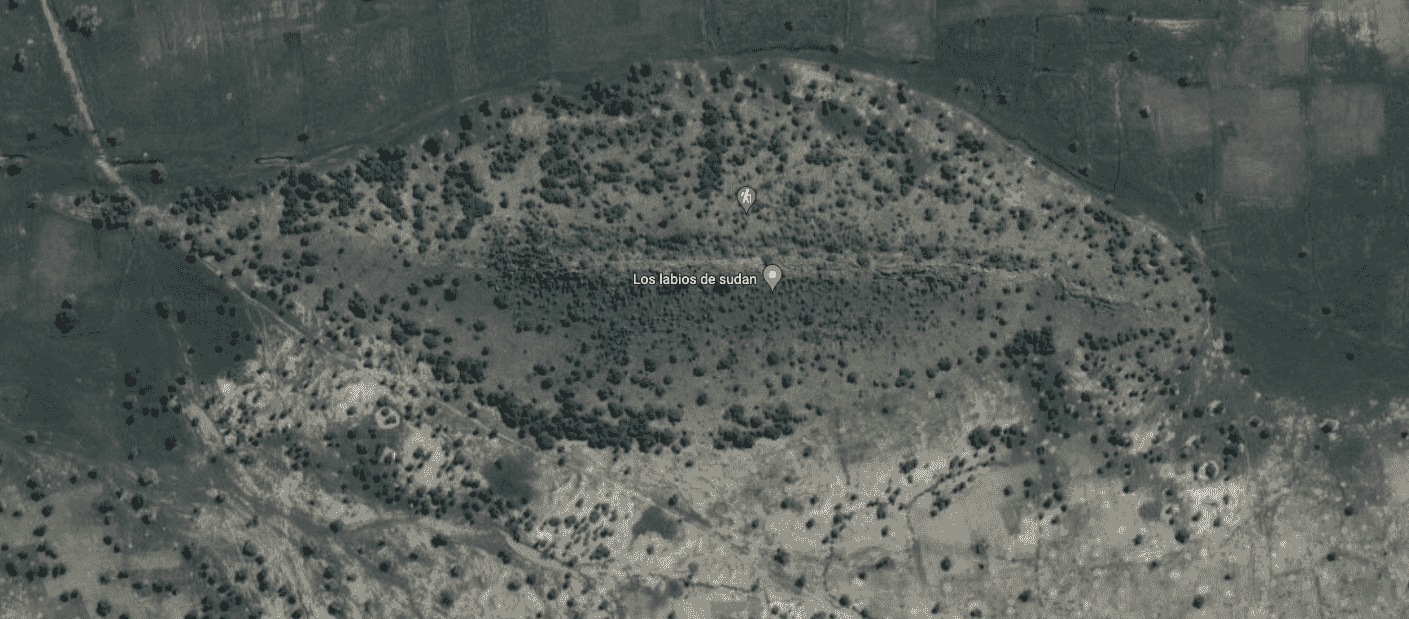
Coordinates: 12° 22′ 13.32″ N, 23° 19′ 20.18″ E
Sudan’s desert is known for its harsh conditions and striking landscapes. On Google Earth, one unusual formation stands out: a natural structure that looks like a giant pair of lips.
This image has fueled many online theories. Some suggest it could be a portal or an unexplained phenomenon. The reality is simple. The “lips” are the result of geological processes. Different shades of sand and rock create an optical illusion when viewed from above.
There is also a cultural connection worth noting. In Sudan, lips have long held symbolic importance. Some tribes have practiced body modifications like lip plates and tattoos to represent beauty, social status, or protection against misfortune. While the rock formation is natural, the cultural practices around lips give it added relevance when viewed in this context.
Coordinates: 33.8444° N, 134.1559° E
In a remote valley in Japan is Nagoro, a village that once had a strong population but has since declined sharply. Today, more than 300 life-sized scarecrows fill the village, all made by a local artist named Tsukimi Ayano.
Each scarecrow is built to resemble former villagers or fictional characters. They are placed in everyday scenes, such as tending gardens, fishing by the river, or waiting at a bus stop. The scarecrows are so detailed that Google Street View sometimes mistakes them for living people and automatically blurs them.
Nagoro is now known as the “Scarecrow Village” and draws visitors interested in seeing the handmade figures. For Ayano, the scarecrows are a tribute to the village’s history and a way to maintain a sense of life in a place that has grown quiet. Even the village’s closed school is now populated by scarecrow students, standing in classrooms once filled with real children.
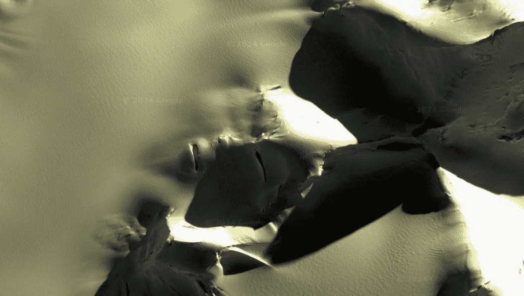
Coordinates: 50° 0′ 38.20″ N, 110° 06′ 48.32″ W
If you are flying over Canada and spot a giant head wearing a headdress, you are seeing the Badlands Guardian. It is a natural rock formation that looks like a human face.
The human-like appearance is an example of pareidolia, the tendency to see faces in objects and landscapes. People experience this with clouds, toast, and even craters. Lynn Hickox first spotted the Guardian in 2005, and the image quickly spread online. The “earphones” seen in the figure are not part of the original formation. They are a road and an oil well added much later.
The Badlands Guardian is not a sculpture. It is a valley shaped by light, shadow, and the erosion of soft rock. The name “Badlands Guardian” was chosen through a radio contest.
The formation is located in the badlands of Alberta, an area shaped by wind and rain over thousands of years. The landscape is dry, rugged, and remote. Most people view the Guardian through Google Earth. The surrounding region is connected to the Siksika First Nation and has a long history tied to the land.
Coordinates: 31.029° N, 37.641° E
In the deserts of Jordan, large stone wheels stretch across the landscape. Some are older than Peru’s Nazca Lines. Locals call them the “works of the old men.” Scientists have studied them for decades but their exact purpose remains unknown.
Pilots first noticed the wheels from the air in the 1920s. From the ground, the formations appear as scattered piles of rocks, but from above, their shapes become clear.
More than 1,000 stone wheels have been recorded. Some reach up to 70 meters in diameter and are mostly found on ancient lava fields. A few are aligned with the sunrise during the winter solstice or other astronomical events. This has led scientists to suggest they may have been used to mark time or for ceremonial activities. Other theories include their use as animal traps or as gathering places for rituals.
Jordan’s stone wheels are not the only unexplained formations in the area. Nearby, researchers have also found giant bullseyes, triangles, and massive circles, each with a purpose that is still unknown.
Coordinates: 30.0305° S, 115.3565° E
In the Australian desert, there is a giant triangle roughly the size of a football field, marked by lights at each corner. It is known as the Outback Triangle and sits in a remote area often linked to strange reports.
Pilots have reported computer problems when flying near the triangle. Some believe there could be a magnetic field in the area that interferes with electronics.
The location of the Outback Triangle is almost exactly opposite the Bermuda Triangle on the globe. This has led to theories that the two sites might be linked by a magnetic connection affecting navigation.
The area around the Outback Triangle is also important in Aboriginal history. Traditional stories and cultural sites add another layer of significance to the region. There is also a real star formation, the Southern Triangle constellation, that matches the shape of the ground formation.
Coordinates: 44.244273° N, 7.769737° E
In Colletto Fava, Italy, a giant pink stuffed bunny once sat on a mountainside. Created in 2005 by a group of Austrian artists, the artwork was 200 feet long and designed to look like it had fallen from the sky, spilling its insides across the ground.
The project, called “Hase,” was meant to be interactive. Visitors could climb on it and explore, treating the bunny like part of a large, open story. Though the idea sounded strange, the artists wanted the experience to be playful, not grim.
The bunny was visible from Google Earth and quickly became a landmark. Over time, though, weather took its toll. By 2016, Hase had mostly rotted away. Today, only small pieces of pink fabric remain, marking the site where the giant bunny once attracted attention.
Coordinates: 72° 00′ 36″ S, 168° 34′ 40″ E
In Antarctica, there is a formation that looks like a giant broken human face. It is another example of pareidolia, where natural shapes appear to resemble familiar images.
The “Broken Face” has sparked many ideas online. Some say it looks like a movie villain, while others see the face of a Native American chief. Its strange appearance has fueled even more attention because of how easy it is to explore remote places with Google Earth.
Antarctica’s isolation and harsh environment often lead people to speculate about hidden structures beneath the ice. There are theories about secret bases, giant doors, and even abandoned ice ships. However, most of these “discoveries” are natural features. They are usually rock formations, ice patterns, or shadows that happen to look unusual from above.
Coordinates: 35.524423059378705, -104.57172606840156
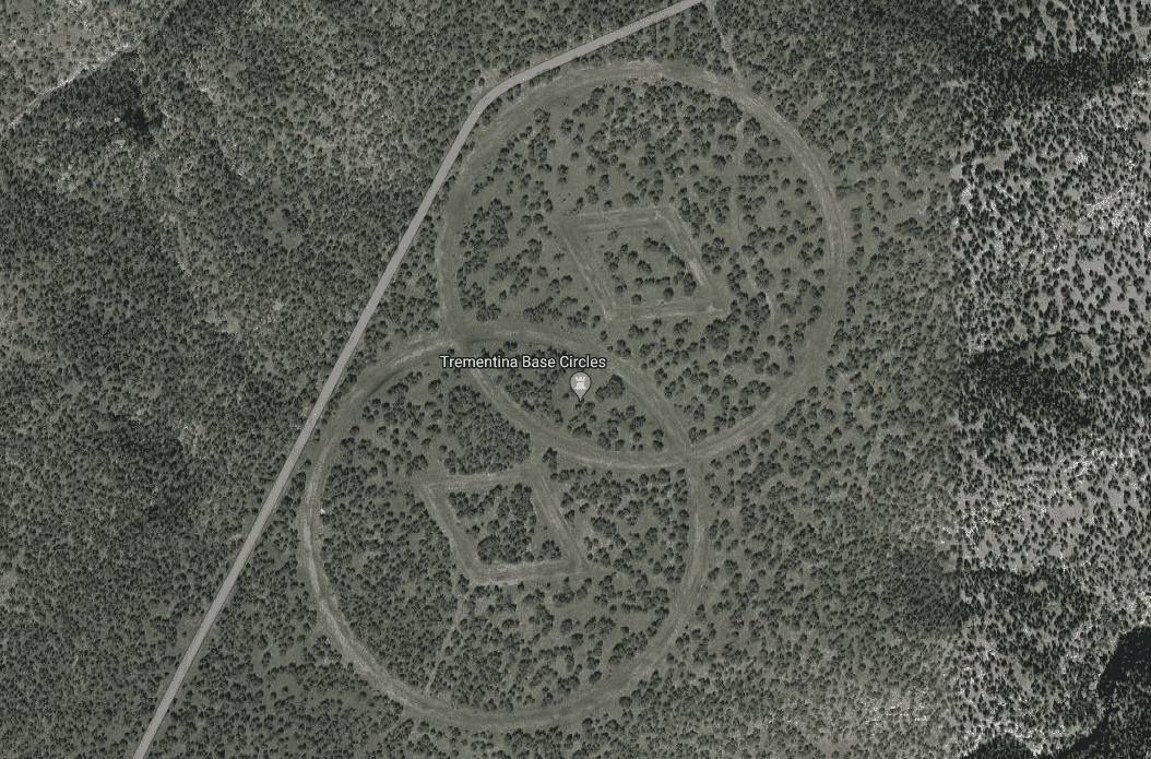
Near Mesa Huerfanita in the New Mexico desert is Trementina Base. It was built by the Church of Scientology to store the writings and recordings of its founder, L. Ron Hubbard, in case of catastrophic events.
The facility is said to be a complex underground network of tunnels, heavily secured and designed to survive a nuclear attack. On the surface, strange symbols are carved into the ground. These markings are reportedly intended to help guide Scientologists back to the site from space.
The mystery around Trementina Base is increased by its location. It is not far from Roswell, known for its UFO stories, and the region itself is full of local legends. Some tales speak of evil spirits trapped in caves, guarded by stone statues shaped like cats.
Coordinates: 32.676193° N, 117.157661° W
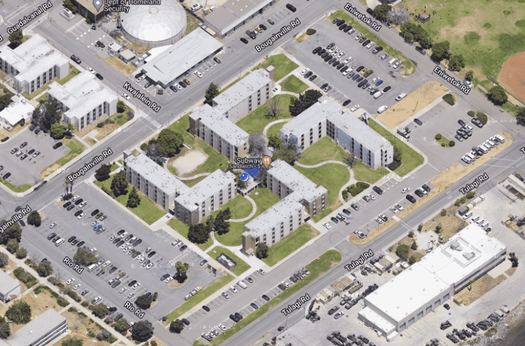
At a Navy base in San Diego, a building complex has drawn controversy because its layout forms the shape of a swastika when viewed from above.
Built in the 1960s, the four L-shaped buildings were designed for practical use. At the time, without satellite imagery, no one noticed the shape they created. Decades later, with the rise of Google Earth, the issue became widely known.
Theories quickly surfaced, questioning whether the design was intentional. The Navy has consistently stated that the layout was an accident, not a deliberate message. In response to public concern, they made changes to the site. They planted trees, added landscaping features, and installed solar panels to break up the image. More recently, they launched a full renovation project to redesign the complex into a simple square.
Not everyone agrees with the approach. Some argue that the entire structure should be demolished and rebuilt from scratch. While debate continues, the Navy maintains that the original design was not intended to symbolize hate.
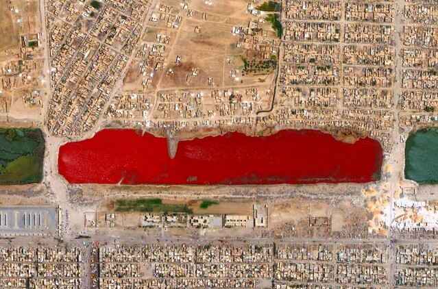
Coordinates: 33.3961° N, 44.4875° E
In 2007, users of Google Earth noticed a strange sight in Iraq. Near Baghdad, a lake appeared blood-red from above and was quickly nicknamed Blood Lake.
Many theories circulated about the cause. Some blamed pollution from nearby factories. Others suggested the lake was contaminated with blood from slaughterhouses. However, scientists pointed to a more common explanation. In salty lakes, certain types of algae or bacteria can bloom and turn the water red. Similar events have been recorded in places like Iran.
Over time, the lake returned to its normal color. The exact cause of the red appearance was never officially confirmed, but the biological explanation remains the most likely.
Coordinates: 45.694355° N, 106.948480° E
In Mongolia, there is a lake that appears bright red from above. Known informally as Blood Lake, its unsettling color has led to many rumors and stories.
Some claim the lake is haunted or even a gateway to the underworld. Scientists offer a simpler explanation. The red color is caused by algae and microorganisms that thrive under certain conditions.
Mongolia is known for its wide grasslands, tall mountains, and many lakes. Blood Lake stands out sharply against the usual blue and green landscape. Its isolated location and strange color have made it a popular spot for people exploring Google Earth.
Coordinates: 40.821233140822464, 14.077730718783444
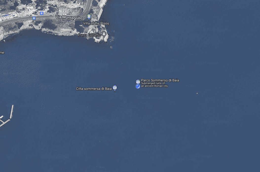
Baia was once a luxurious resort town near Naples, Italy, where wealthy Romans, including figures like Caesar and Nero, spent their vacations. They came for the hot springs, coastal views, and the lively social scene.
Over time, volcanic activity in the region caused the ground to sink. The Mediterranean Sea slowly covered Baia, and today much of the ancient city lies underwater. It is now an archaeological park, where visitors can explore submerged Roman ruins.
The town’s name is said to come from Baius, a sailor from Odysseus’s crew. The network of tunnels beneath Baia has also fueled theories that it could have inspired myths about entrances to the underworld in Greek stories.
Despite being in a volcanic zone, scientists are working to protect Baia. Underwater sensors monitor the site to help preserve it. Visitors today can see the ruins through glass-bottom boats, snorkeling, or scuba diving, viewing ancient statues, mosaics, and other remains of Roman life.
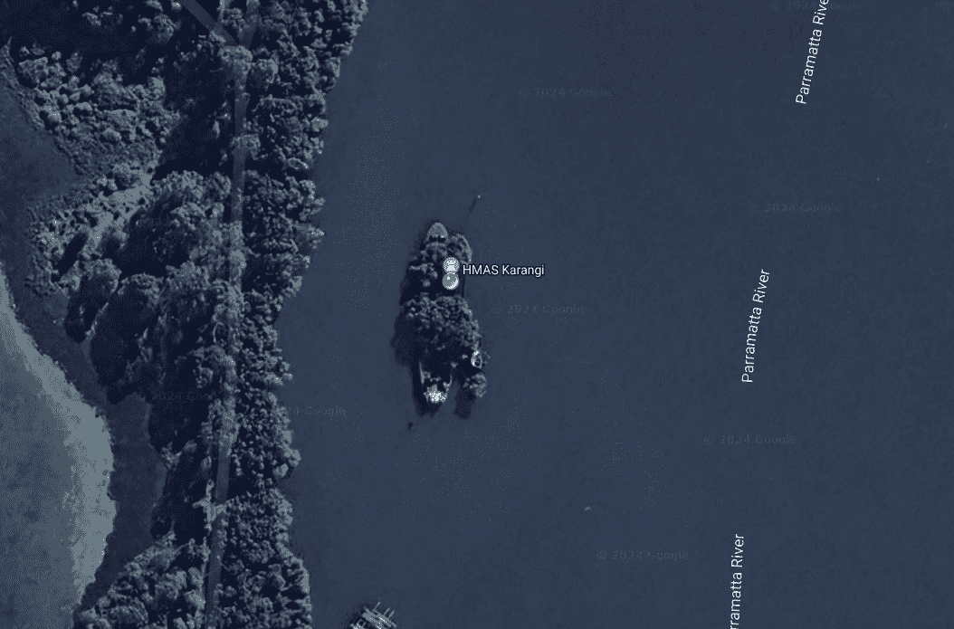
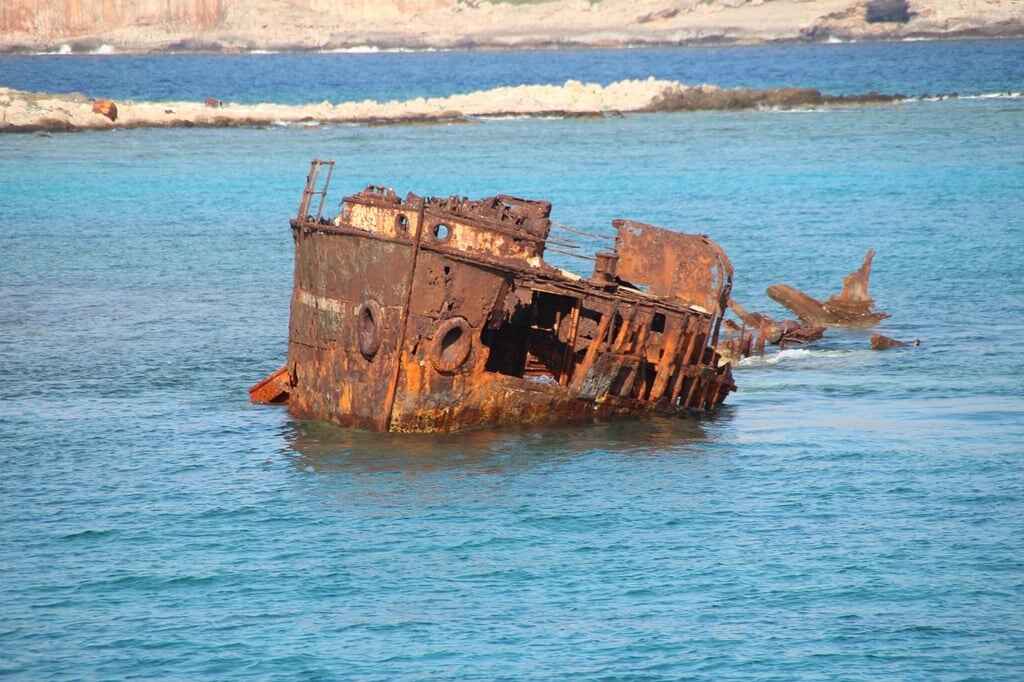
Coordinates:-33.83647313578192, 151.08048915379533
The SS Ayrfield, often called the “Floating Forest,” sits in Homebush Bay, Sydney, Australia. It is a shipwreck that has been overtaken by nature, creating a striking and unusual sight.
Built in 1911, the SS Ayrfield was used to transport cargo along the Australian coast. In 1972, it was decommissioned and sent to a scrapyard in Homebush Bay. The scrapping process was never completed, and the ship was left to decay.
Over time, mangrove trees began to grow inside the rusting hull. The ship’s frame and the dense greenery created a strong visual contrast, turning the wreck into a floating forest. Today, the SS Ayrfield is a popular subject for photographers and visitors who want to see a rare example of nature reclaiming a piece of human history.
Coordinates: 22.7196° N, 69.5261° E
The Arabian Sea, off the coast of India, holds a large number of shipwrecks. For centuries, it served as a major route for trade but also proved dangerous due to severe weather and difficult waters. Many ships sank here, leaving behind artifacts for future discovery.
One important site is Bet Dwarka. Archaeologists have found Roman pottery and tools there, showing that it was once an active center connecting India to the Roman Empire. Strong underwater currents helped preserve parts of the wreck, while also demonstrating the dangerous conditions sailors faced.
European ships faced similar challenges. During the colonial era, many vessels from the East India Company sank in the Arabian Sea. Sharp coral reefs and violent storms destroyed ships carrying valuable cargo, leaving behind important archaeological finds.
Modern technology, including aerial and satellite imaging, has helped locate Portuguese shipwrecks in the region. These wrecks have revealed cannons, construction materials, and ivory. Each discovery gives researchers more insight into ancient trade routes, maritime battles, and everyday life at sea.
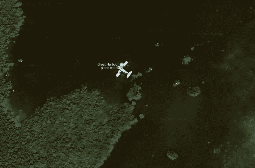
Coordinates: 25.71896620673477, -77.81999522970831
The Bahamas is known for its clear water and beaches, but below the surface lies a collection of plane wrecks, each with its own history. These wrecks are easy to reach and attract divers and snorkelers because of the marine life that now surrounds them.
One of the most famous is a drug-smuggling plane linked to Pablo Escobar. It crashed in the 1980s and now sits in shallow water. Although it has a criminal past, today it serves as a dive site filled with fish.
Bimini Island also features a few wrecks. Divers can explore these partially submerged planes, which have become underwater habitats. However, not all wrecks are from older events. In 2001, a plane crash near the Bahamas claimed the life of singer Aaliyah. This tragedy led to stricter flight regulations in the area.
Near Staniel Cay, another plane wreck is believed to be linked to drug smuggling operations. Like the others, it rests in shallow water and has become a popular dive site known for its easy access and colorful sea life.
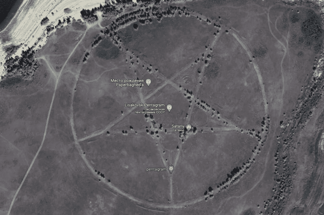
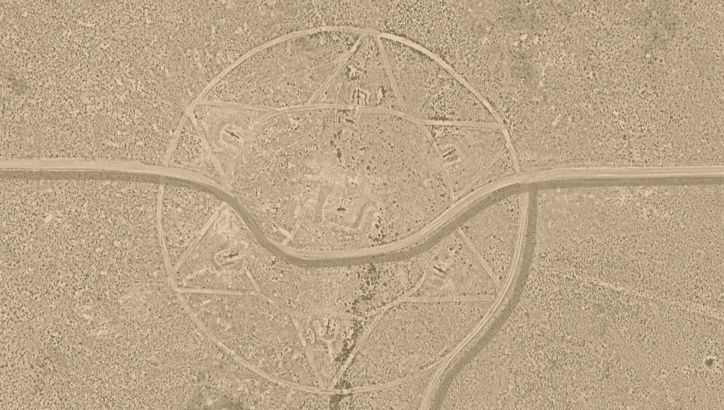
Coordinates: 552.47962028384223, 62.18579069718502
In Kazakhstan, a large five-pointed star is etched into the ground near a lake close to the city of Lisakovsk. Seen on Google Earth, it has led to many conspiracy theories, including claims of devil worship.
The true explanation is straightforward. The star is the remains of an unfinished Soviet-era park. During the time when Kazakhstan was part of the Soviet Union, stars were common symbols used in architecture, flags, and monuments.
Archaeologists believe the roads for the planned park were laid out in the shape of a star, following Soviet design traditions. Although the park was never completed, the road outlines remain visible from above. The site is now abandoned and overgrown, which adds to its eerie appearance.
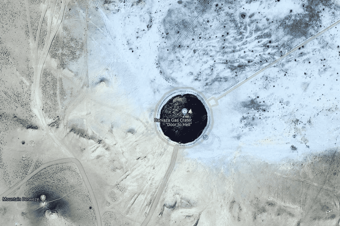
Coordinates: 40.2525° N, 58.4395° E
The Darvaza gas crater, often called the “Gates of Hell,” is a large, burning hole located in the Karakum Desert of Turkmenistan.
The crater’s origin dates back to the 1980s, though the exact events are unclear. One common theory is that Soviet scientists accidentally triggered the collapse during a drilling project and set the gas alight to prevent dangerous emissions. Regardless of how it started, the crater has become a major tourist destination, attracting about 10,000 visitors each year.
At night, the flames light up the desert sky. The site reaches temperatures close to 1,000 degrees Celsius. Despite the intense heat, the fire burns without producing smoke, giving a clear and continuous view of the flames.
The government of Turkmenistan has discussed extinguishing the fire due to environmental concerns and the loss of natural gas. So far, no action has been taken, and the Gates of Hell remain active.
Coordinates: 48.700568° N, 6.189389° E
In Nancy, France, a strange image captured on Google Maps has drawn attention. A blurry figure seen standing on a balcony has sparked online theories about ghosts and aliens.
The image, known as the “Ghost on the Balcony,” shows a tall figure with what appears to be glowing eyes. Some people speculated that it was a supernatural being. A more grounded explanation suggested that it was likely a tiki statue, with its shape distorted by the camera angle.
Theories became even more intense after Google blurred the entire scene. This action led users to question why something seemingly harmless would be hidden.
This case highlights how small local anomalies can quickly turn into widespread mysteries online, fueled by speculation and limited information.
Coordinates: 19.22° S, 159.93° E
For more than 100 years, maps showed a place called Sandy Island in the Coral Sea. Its existence was supported by early eyewitness reports, but in reality, Sandy Island never existed.
The story began in 1876 when a whaling ship reported spotting land in that location. Based on this, Sandy Island was added to maps and charts. Even after later ships failed to find it, the island remained on navigational charts to help ships avoid a possible hazard.
In 2012, a research vessel sailed directly through the coordinates where Sandy Island was supposed to be. They found only deep ocean, and as a result, the island was removed from digital maps.
Scientists believe the original sailors may have seen a large floating mass of pumice, volcanic rock that can float on water, and mistaken it for solid land.
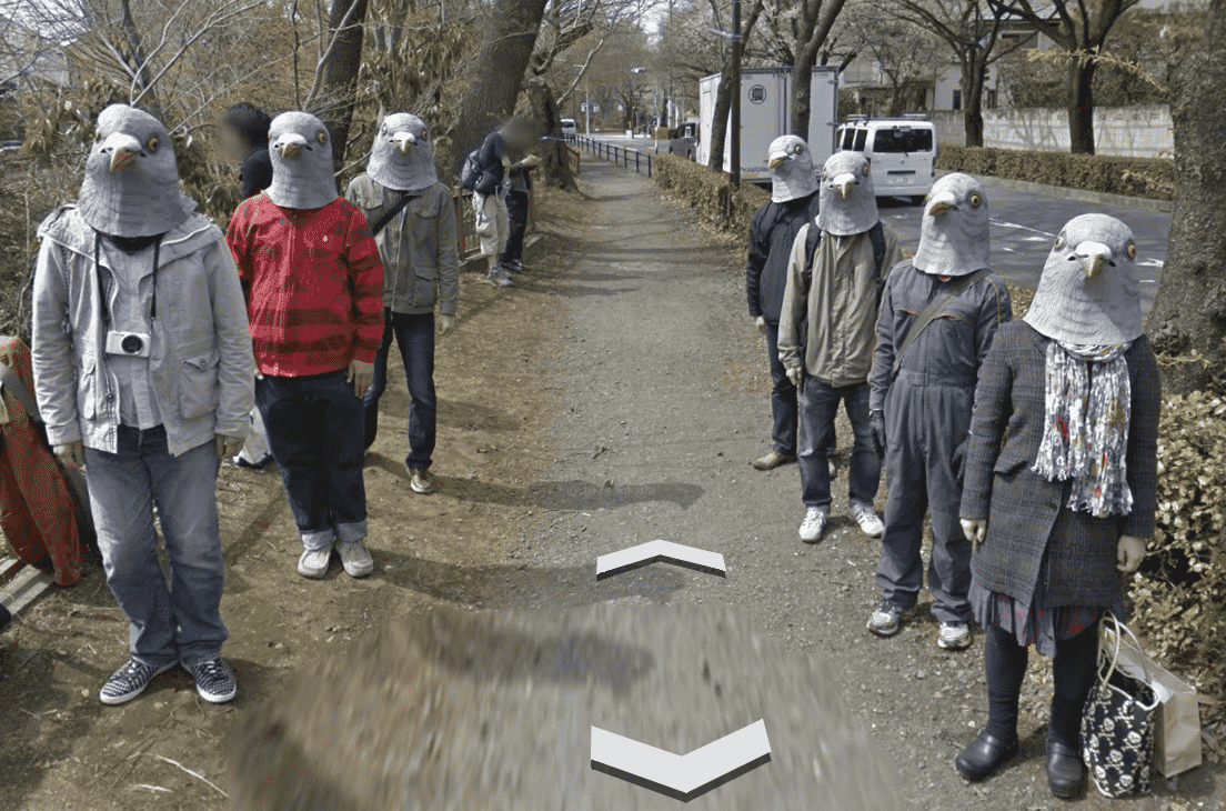
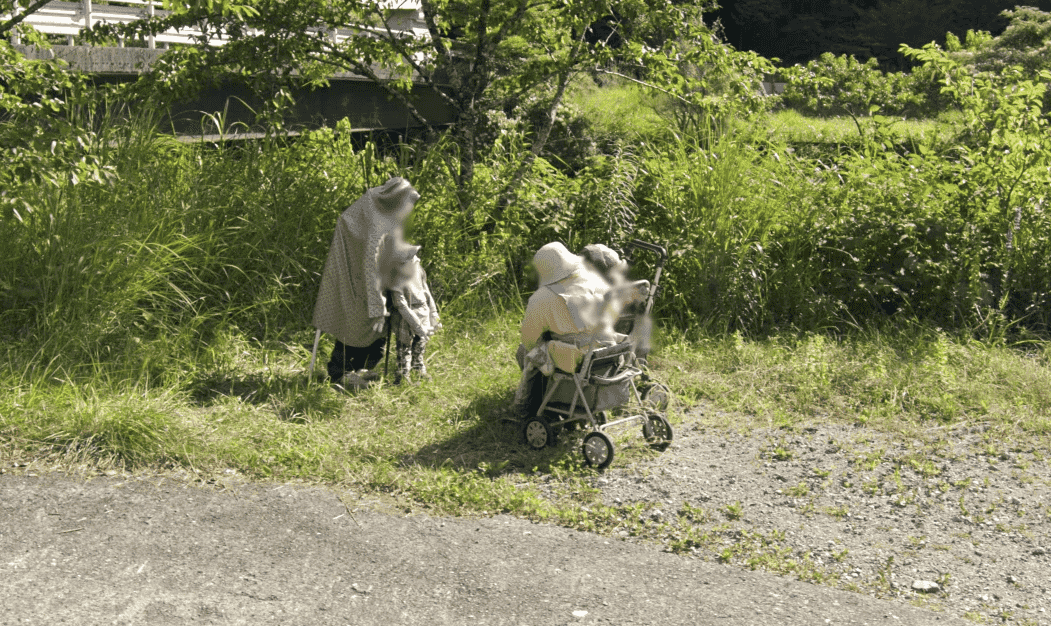
Coordinates: 35.7040744° N, 139.5577317° E
If you explore Google Maps around Tokyo, you might come across a group of people wearing realistic pigeon masks. They appear to follow the Google Street View car, posing in ways that catch viewers off guard.
These “Pigeon People” are believed to be a prank by students from a nearby art school known for its creative projects. Given the location and style of the prank, it fits the profile of student-led work.
The prank also connects to Japan’s tradition of blending art with everyday life. In Japanese folklore, pigeons are often seen as symbols of luck and adaptability. The images of the Pigeon People quickly went viral, gaining attention on social media worldwide.
It shows how art can appear unexpectedly, even during a virtual map search.
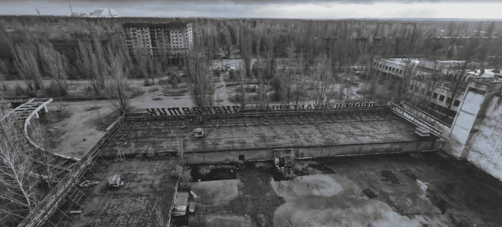
Coordinates: 51.4041° N, 30.0571° E
Pripyat, Ukraine, was built to house workers for the Chernobyl nuclear power plant. Before the disaster, it was a busy city with nearly 50,000 residents. In 1986, when one of the reactors exploded, the entire city was evacuated in a single day.
Today, Pripyat remains abandoned. The Ferris wheel at the amusement park, which was scheduled to open shortly after the disaster, still stands unused. Schools, hospitals, and homes have been left to decay, and nature has taken over many parts of the city. Wildlife, including elk, wolves, and wild horses, now move freely through the empty streets.
To contain the radiation from the destroyed reactor, a giant steel structure, known as the New Safe Confinement, now covers the site. It was built to help protect the surrounding area for at least the next 100 years.
Coordinates: 22° 18′ 14.15″ N, 114° 11′ 24.66″ E
The Whampoa Boat-Shaped Shopping Centre is a distinct landmark located in Whampoa Garden, the largest private housing estate in Hung Hom, Kowloon. The mall is 360 feet long and designed to look like a luxury cruise ship.
The site has historical roots. It was once home to the Whampoa Dockyard, one of Asia’s busiest shipyards during the 1800s. More than 4,000 people worked there, building some of the largest ships in Hong Kong. During World War II, the dockyard was bombed by Japan and later shut down.
In 1985, the area was redeveloped. To honor its shipbuilding history, the Whampoa Shopping Centre was constructed in the shape of a ship, preserving a connection to the area’s past.
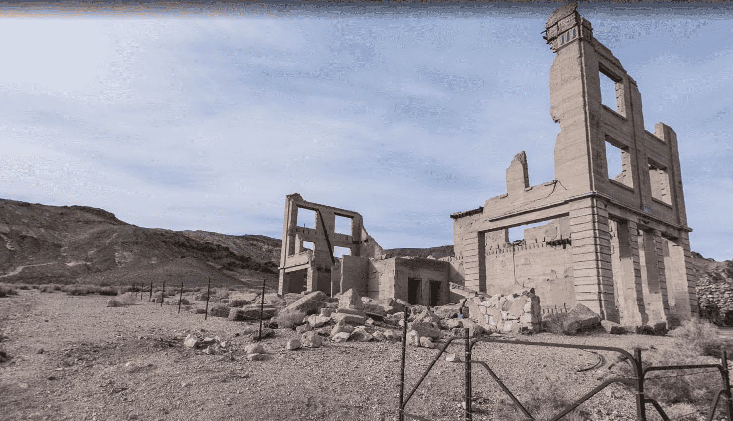
Coordinates: 36.9005° N, 116.8273° W
Rhyolite, Nevada, is a ghost town that grew and collapsed during the early 1900s gold rush.
In 1905, prospectors discovered gold in the Bullfrog Hills. People quickly moved in, and the town developed almost overnight. By 1907, Rhyolite had electricity, large buildings, and even a red-light district.
The success was short-lived. By 1910, the gold had run out, and the town was mostly abandoned. Streets emptied, and buildings were left to decay.
Today, Rhyolite is a tourist destination. Visitors come to see the ruins, including a unique house built entirely out of glass bottles, left as a reminder of the town’s brief rise and fall.
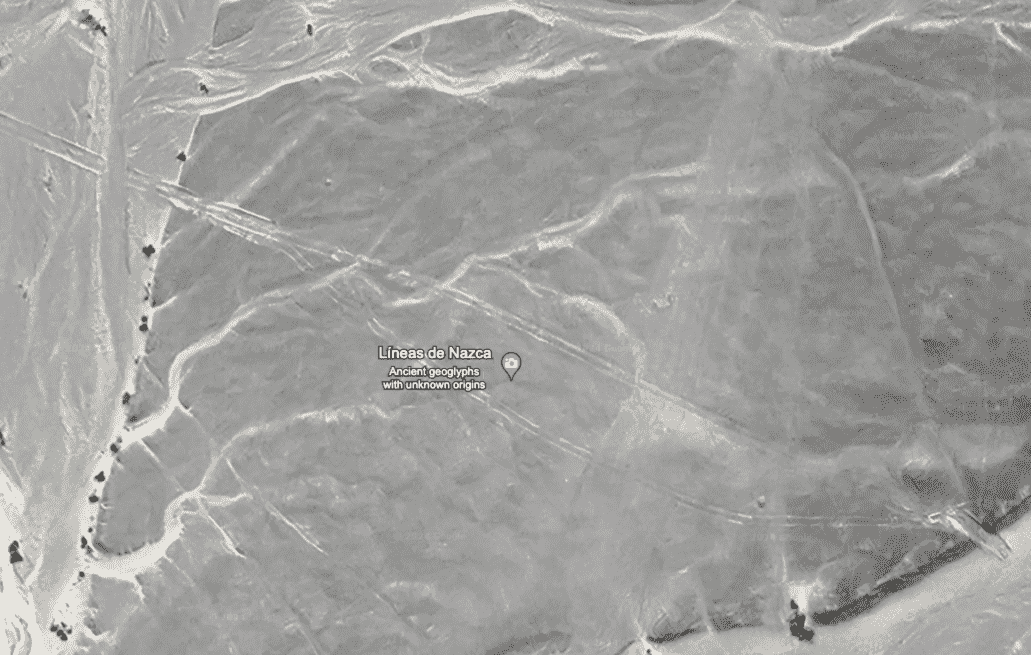
Coordinates: 14.7390° S, 75.1300° W
In the Peruvian desert, the Nazca Lines stretch across the dry plains. Created by the Nazca culture between 200 BC and 600 CE, these massive ground drawings depict animals like hummingbirds, monkeys, spiders, and various geometric shapes. Some designs are as large as a football field.
The purpose of the Nazca Lines remains uncertain. One theory suggests they were used as a giant calendar to track celestial movements. Maria Reiche, a researcher who dedicated her life to studying the lines, strongly supported this idea, arguing they functioned as a celestial guide.
Another theory proposes that the lines had religious significance. Archaeologists have found platforms near some figures and seashell fragments linked to water rituals, suggesting the designs played a role in ceremonies. This theory is reinforced by the desert’s harsh, dry environment where water was vital.
Recent research by Japanese teams using drones and aerial photography identified 168 new geoglyphs, including figures of humans and animals. Preservation efforts are critical. While the desert’s dry climate has protected the lines for centuries, urban expansion and mining now pose real threats. Peruvian authorities and international organizations like UNESCO are actively working to conserve the site.
The Nazca Lines continue to offer important insights into the culture that built them, showing both artistic skill and complex belief systems.
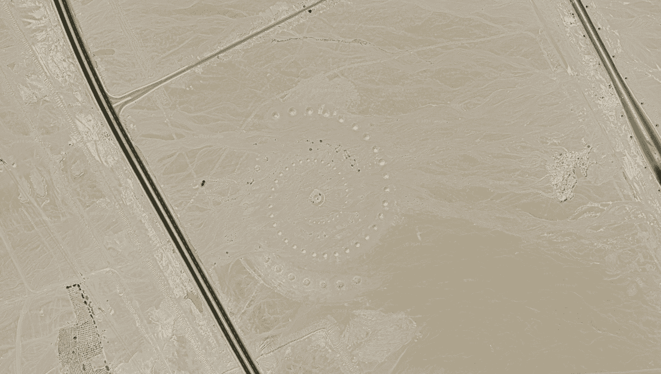
Coordinates: 27.380583° N, 33.631839° E
In the Egyptian desert near the Red Sea lies Desert Breath, a massive land art project visible from space. It was created in 1997 by three Greek artists.
Desert Breath consists of a double spiral made from sand. To build it, the artists dug out sand to form smaller cones and used the removed sand to create larger mounds beside them. The center of the artwork originally featured a pool of water, which has since dried up.
The artists designed Desert Breath to make visitors feel small compared to the vastness of the desert. The spirals and pointed shapes were inspired by natural sand dunes and intended to show the connection between human creativity and natural landscapes.
Natural erosion has slowly worn down the shapes, making Desert Breath a record of time passing in the desert. Although it is gradually fading, it remains a site of interest for visitors and people exploring through satellite imagery. Some conspiracy theories have tried to suggest it was built by aliens, but it is well-documented as a human-made project.
Fred Metterhausen is a Chicago based computer programmer, and product owner of the current version of Maptive. He has over 15 years of experience developing mapping applications as a freelance developer, including 12 with Maptive. He has seen how thousands of companies have used mapping to optimize various aspects of their workflow.