Geospatial intelligence combines geographic data with analytical processes to extract meaningful information about physical locations and human activities. This field merges satellite imagery, sensor data, and mapping technologies with advanced computational methods to produce actionable insights for decision-makers across government and commercial sectors. The discipline has expanded from its military origins to serve construction companies monitoring project sites, agricultural firms tracking crop health, and urban planners managing infrastructure development.
Table of Contents
The National Geospatial-Intelligence Agency processes information from multiple collection platforms, receiving more data than analysts can effectively review through traditional methods. Vice Admiral Frank Whitworth has positioned NGA to address this challenge through what the agency calls the year of ‘NGAI’, representing a comprehensive integration of artificial intelligence into geospatial analysis workflows. The agency established a new program executive office for advanced analytics under Rachael Martin’s leadership, who previously directed the NGA Maven program.
This organizational restructuring includes two new director positions overseeing AI standards and programs, plus an executive director leading AI operations. NGA has committed $708 million through their Sequoia request for proposal, marking their largest data labeling effort across a potential seven-year period. These investments support the development of machine learning capabilities that can process satellite imagery and sensor data at speeds impossible for human analysts alone.
The ASPEN program, launched in 2023, provides automated analytic capabilities that help NGA analysts generate warning indications for customers. This suite of tools processes massive data increases through AI-powered automation, enabling faster threat detection and assessment. The agency’s AGAIM accreditation program establishes standardized evaluation frameworks for AI models, implementing risk management protocols while promoting responsible AI adoption across the geospatial intelligence enterprise.
The global geospatial AI market reached $38 billion in 2023 and projections indicate growth to $64.60 billion by 2029, representing a compound annual growth rate of 9.25 percent. Construction firms like Skanska deploy drones to capture high-resolution imagery for monitoring assets and collecting accurate geospatial data, reducing project costs while improving safety metrics. These systems extract information from imagery to feed digital twin models, allowing project managers to identify potential risks and optimize building performance throughout construction phases.
Agricultural applications have produced measurable efficiency gains across farming operations. FlyPix AI’s technology serves energy, construction, and agriculture sectors by monitoring infrastructure and detecting assets with precision. Farmers use these tools for automated detection of invasive species, while foresters assess tree volumes and species distribution without conducting time-consuming field inspections. Granular, an agriculture technology company, analyzes satellite imagery from Planet Labs and Maxar Technologies to monitor crop health and optimize field management decisions.
The oil and gas industry applies geospatial AI for automated extraction of flares, new well pads, and field access roads from satellite imagery. These capabilities enable continuous monitoring of remote assets that would otherwise require expensive site visits and manual inspections.

Houston Public Works transformed its infrastructure management by integrating GIS software, AI, mobile applications, and real-time data streams. Live asset tracking and situational awareness tools have enhanced operational efficiency and emergency response capabilities across the city’s water and sewer systems. The Bavarian State Ministry of Housing, Building, and Transport tested an artificial intelligence system on a major German highway that analyzes images to identify early signs of road wear, enabling maintenance scheduling before major repairs become necessary.
The US Army Corps of Engineers applies geospatial AI to analyze millions of vessel-tracking pings, identifying locations where barges and container ships face delays from sediment accumulation. This proactive approach to dredging operations saves approximately $100 million annually through optimized scheduling and resource allocation. Finnish forestry operations use artificial intelligence to analyze imagery and weather data for forest inventory predictions and maintenance planning, supporting refined growth patterns and harvest cycle optimization.
Some models extract building footprints for urban planning, classify structures for insurance purposes, and generate change maps from time series data. During disaster events, these tools enable rapid damage assessment from drone and aerial imagery, trained on the Low Altitude Disaster Imagery v2 dataset containing over 10,000 aerial images labeled by Civil Air Patrol volunteers.
The UN-SPIDER network has documented measurable improvements in global disaster response coordination. Regional Support Offices operate containerized deep-learning pipelines on commercial or sovereign clouds, with three RSOs integrating GeoAI outputs into national early-warning chains. These implementations have reduced evacuation lead times by up to six hours in cyclone-prone deltas. Open-weight foundation models such as Prithvi and Satlas have lowered entry barriers, enabling analysts in low-income states to match the analytic throughput of space-faring nations.
Microsoft partnered with Impact Observatory to build an AI-powered land-cover map, enabling automated land-use monitoring at 10-meter resolution. This capability increases the scale and frequency of global observations compared to previous manual methods. AT&T utilized climate data and geospatial analysis to map potential flooding risks to its US infrastructure through 2050, identifying facilities and supply chains vulnerable to coastal flooding.
Government officials use these technologies to model urban development impacts, assess resource availability to populations, forecast infrastructure deterioration, and identify land-use changes. The automated detection of new buildings enables proactive regulatory action and planning adjustments based on actual development patterns rather than projected estimates.
NGA leverages artificial intelligence, machine learning, next-generation sensors, cloud computing, and unmanned systems in collaboration with Combatant Commands. The agency provides the Department of Defense and Department of Homeland Security with satellite imagery and analysis, aerial photography and mapping, geospatial data analysis, and Maritime GEOINT capabilities for border protection and threat assessment.
Project Aegir, funded through the Defense Innovation Unit’s commercial solutions opening process, focuses on commercial techniques to identify, monitor, and track illicit maritime vessel activity in the US Indo-Pacific Command area of responsibility. This program demonstrates how geospatial intelligence supports naval operations and maritime domain awareness through automated vessel behavior analysis.
Real estate professionals employ geospatial intelligence to analyze demographic shifts, housing trends, and economic developments across different areas. These tools assess environmental risks through geographical data, including flood zones, earthquake fault lines, and wildfire areas. Starbucks uses location analytics to identify optimal store locations by analyzing demographics, traffic patterns, and nearby businesses.
Ride-sharing companies Uber and Lyft apply mobile mapping and geolocation to match riders with drivers and optimize routes. Waze provides real-time traffic information and alternative routes through community-driven navigation data. These applications demonstrate how geospatial intelligence enhances operational efficiency and customer service in consumer-facing businesses.

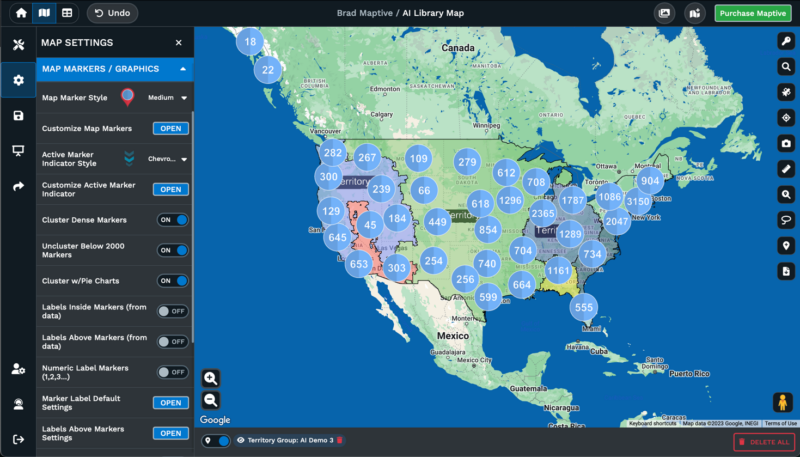
Maptive IQ introduces improved drive-time polygons, territory management features, and demographic insights. The platform’s drive-time polygon tool calculates multi-hour service areas with high accuracy, while a combinatorial boundary feature allows users to define zones using custom criteria. Users can combine official and custom boundaries for analyzing trade areas, market gaps, or complex sales territories.
Demographic overlays in Maptive IQ access mobile signals and purchasing trends data, enabling marketers to target high-intent areas. The demographic layer pinpoints underserved areas with up to 90 percent precision based on source data, supporting retail and service location planning decisions. Monthly user costs remain lower by more than one-third for comparable features versus Esri and other full GIS tools, according to sales and peer data.
Maptive’s automated territory optimization technology uses an algorithm developed by We Map Sales, specializing in territory optimization technology. Sales team managers complete territory design tasks in minutes rather than days, spending up to 75 percent less time on planning. Companies using automated sales territory alignment report 15 percent revenue increases through identifying upsell opportunities, while businesses see 20 percent sales productivity improvements with travel-efficient and balanced territories.
The platform provides filter and grouping capabilities for segmenting data by multiple variables, heat mapping functionality for visualizing data density patterns, boundary creation tools for defining custom territories, and custom region definition features supporting complex geographic analysis. Planned CRM integrations will connect the platform to existing customer relationship management systems, expanding data integration capabilities for business users.
Geospatial intelligence has transitioned from specialized government applications to widespread commercial adoption across industries. The documented benefits include hundreds of millions saved in infrastructure maintenance, reduced evacuation times during disasters, and improved agricultural yields through precision farming. As platforms like Maptive provide accessible interfaces and affordable pricing models, organizations of all sizes can leverage geographic data analysis for operational improvements and strategic planning. The convergence of satellite technology, artificial intelligence, and cloud computing continues to expand the practical applications of geospatial intelligence across government and commercial sectors.
Fred Metterhausen is a Chicago based computer programmer, and product owner of the current version of Maptive. He has over 15 years of experience developing mapping applications as a freelance developer, including 12 with Maptive. He has seen how thousands of companies have used mapping to optimize various aspects of their workflow.
