

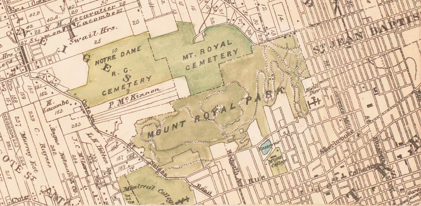
A cadastral map shows the parcels that exist on paper, with their identifiers, dimensions, ownership records, and assessed values. What it does not show, and what surveyors and county GIS staff spend most of their time correcting for, is the gap between the line drawn on the map and the iron pin set in the ground. The map is a registry of legal claims on land, and the registry is only ever as accurate as the last survey that updated it for the parcel in question.
Core Components of a Cadastral Map
The cadastral map is built around one repeating unit, the parcel. Every line, label, and attribute exists to define a parcel, identify its owner, and tie it to the tax roll.
Parcels as the Unit of Land Administration
A parcel is the smallest piece of land treated as a single ownership and taxation unit. A house with a yard, a 40-acre farm, and one share of a 200-acre ranch split for inheritance are each one parcel with its own boundary lines and parcel number. The cadastral map is the assembled picture of every parcel in a defined area, usually a county.
Boundaries, Bearings, and Distances
The lines on a cadastral map encode the bearings (compass directions) and distances along each side of a parcel. A residential lot might be described as 60 feet along the street, 120 feet deep on each side, and 60 feet across the rear. These measurements come from boundary surveys recorded in the county’s plat book, which the published map synthesizes into a seamless layer.
Parcel Identifiers and the APN Structure
Every parcel carries a unique identifier. In the US, the common name is the Assessor’s Parcel Number, or APN. A typical APN encodes geography into the number, with segments that refer to the map book, the page within that book, the block or section, and the specific parcel. Formats vary by county, and the APN ties the parcel on the map to its row in the assessor’s database.
Cadastral Maps Across History
Cadastral practice predates almost every other branch of cartography. The earliest records come from ancient Egypt around 3000 BCE, and the through-line from those records to the modern county GIS viewer has always been taxation, conveyance, and dispute resolution.
Ancient Egypt and Mesopotamia
Egyptian surveyors called harpedonaptae, the rope-stretchers, re-established field boundaries each year after the Nile floods receded, using knotted ropes stretched into triangles to set right angles, and their measurements fed a tax record administered by the pharaoh’s officials. Around 1500 BCE, Mesopotamian scribes produced cadastral records on clay tablets to manage farmland, water rights, and tax assessments.
Roman and Medieval Cadastres
Roman surveyors, the agrimensores, produced cadastral registers for taxation across the empire, with a surviving example from Campania dated AD 77 and used to recover state-owned land informally absorbed by private holders. After the fall of Rome, formal cadastral mapping in Western Europe largely lapsed in favor of written descriptions. The medieval exception is the Domesday Book of 1086, which cataloged most of England by owner, tenant, area, and assessed value.
The Napoleonic Cadastre and Its Inheritors
In 1807 Napoleon Bonaparte ordered the creation of a national cadastre for France, with every parcel mapped by physical location, ownership, area, land use, and assessed value, standardized across an entire country for the first time in modern Europe. The Napoleonic cadastre became the structural template for most continental European systems and many former French and Spanish colonies. Title-based and Torrens-style registries in England and Australia look different from the French model but treat the parcel as the same atomic unit.
Cadastral Maps Compared to Other Land Maps
Several other documents describe land in formal terms and are routinely confused with the cadastral map. Each answers a different question, and most errors in real estate and planning come from asking one document to do the work of another.
Cadastral Map versus Topographic Map
A topographic map describes the shape of the land surface in contour lines, plus the rivers, ridges, forests, roads, and built features on the terrain. A cadastral map describes the legal subdivision of that same land into parcels. The two layer naturally over one another but answer disjoint questions, which is why a hiker reaches for one and a buyer reaches for the other.
Cadastral Map versus Plat
In US usage, a plat is a subdivision drawing recorded with the county to define new parcels when a tract is split. A plat is itself a cadastral document. The published parcel layer is what you get when many recorded plats, older surveys, and historical records are aggregated into a single map. A plat answers what the legal division of one specific tract is, while the parcel layer answers where any parcel in the county sits.
Cadastral Map versus Boundary Survey
A boundary survey is the field measurement of a particular parcel, conducted by a licensed surveyor who sets and verifies physical monuments. The cadastral map is the aggregated record of past surveys, plats, and deed lines. A current boundary survey supersedes the published parcel layer in any disputed case, which is why title companies and lenders require a survey before closing.
Primary Uses of Cadastral Maps
Cadastral data has four working uses, and each tolerates a different level of map error. A planner zoning thousands of parcels tolerates more drift than a surveyor staking a single side yard, and an assessor can absorb error that a property closing cannot.
Property Taxation and Assessment
The original use case from Rome forward is property taxation. The assessor pulls the parcel area, applies a per-acre or per-square-foot value derived from comparable sales, and produces the assessed value that drives the tax bill. Errors of a few feet are tolerable because the resulting valuation error is small, but errors of tens of feet would distort the tax base, which is why counties periodically reconcile parcel data with new aerial imagery.
Real Estate Transactions and Due Diligence
In a real-estate transaction the cadastral parcel layer is the starting point of due diligence, not its conclusion. A buyer pulls the APN, checks the recorded area, frontage, and ownership history, and flags issues from the cadastral viewer. The lender and title company then require a current boundary survey before closing, and that survey routinely turns up encroachments and easements absent from the cadastral map.
Urban Planning and Zoning
Planners use cadastral data at a different scale than buyers do. Zoning districts, overlay districts, and infrastructure corridors are drawn against the parcel layer because the parcel is the legal unit that zoning regulates. Small positional errors wash out at the district scale, and the same data set that is too imprecise for a fence install is adequate for a half-mile commercial corridor along a major street.
Boundary Disputes and Legal Records
When adjacent owners disagree about where a property line runs, the cadastral map is one piece of evidence alongside the recorded deeds, prior surveys, and physical monuments. Courts in most US jurisdictions give greater weight to the surveyed boundary than to the published parcel line where the two disagree, especially where the parcel data was digitized from older paper records.
Modern Cadastral Technology
The shape of cadastral data has changed substantially in the last 30 years, even as the underlying purpose has not. Many counties still maintain the recorder’s plat book, but the working surface for everyone else is a GIS web viewer backed by a parcel layer in a spatial database.
From Paper Plat Books to GIS
Most US counties digitized their parcel data between roughly 1995 and 2015 by scanning the paper plat books and tracing the parcel lines into a GIS layer. The process produced a usable dataset but imported every inaccuracy in the source material plus new errors introduced during tracing. Counties that re-surveyed against modern aerial imagery produced cleaner layers. Counties that digitized once and never returned still carry several feet of positional error in many neighborhoods.
GNSS, LiDAR, and Drone Data Capture
Field cadastral work now relies on RTK GNSS receivers, which use real-time corrections from a base station to fix boundary points to centimeter accuracy. LiDAR scanning captures dense point clouds for rapid mapping over large areas, and drone photogrammetry produces high-resolution orthomosaics at the scale of a single parcel. The combination has compressed the time needed to verify a parcel boundary from days to hours in straightforward cases.
Three-Dimensional and Time-Aware Cadastres
A condominium building stacks dozens of independently owned parcels above one another, and a flat parcel layer cannot represent the ownership, which is why dense urban areas have pushed cadastres into the third dimension. Three-dimensional cadastres add vertical strata so air rights, subsurface utility easements, and stacked unit ownership can be modeled directly. Time-aware cadastres add a temporal axis so boundary changes from subdivision, consolidation, or annexation are queryable by date.
The Limits of the Cadastral Record
The single most useful thing to know about cadastral maps is the gap between the published parcel layer and the legal boundary on the ground. The published map is the assessor’s working record, fit for assessment, planning, and routine due diligence, and routinely treated as more authoritative than it is.
Positional Error in Older Cadastres
Parcel layers digitized from paper plats can show several feet of error relative to GNSS-derived coordinates, and the error is rarely uniform, which is what makes it operationally tricky. One block of a neighborhood may be aligned within a foot of the orthophoto, while the next block is offset by 8 feet because it was traced from a poorly scanned plat. The parcel layer overlaid on aerial imagery in any older subdivision will show fences, driveways, and buildings that do not match the recorded boundaries.
Missing Strata of Mineral, Timber, and Air Rights
The cadastral parcel layer typically shows only the surface owner. Mineral rights, oil and gas leases, timber rights, and air rights can be severed from the surface and held by separate owners with no presence on the parcel map. A homeowner whose parcel sits over a 1920s mineral severance may discover that an oil company holds the right to enter the land and operate equipment on it. Most jurisdictions keep separate registries for severed rights, but the cadastral viewer alone will not surface them.
When to Order a Boundary Survey
The decision rule is simple even when the situation is not. Order a survey before any closing on land, before boundary-affecting construction such as a fence or an addition that approaches a setback line, before easement negotiation, and before any litigation involving an adjacent owner. The cost is typically a few hundred to a few thousand dollars depending on parcel size and complexity, and it is the only document a title company, court, or lender will accept. The cadastral map shows what is on record, the boundary survey shows what is on the ground, and the cost of treating the two as identical is paid by whoever finds out otherwise the hard way.
Frequently Asked Questions
What is the purpose of a cadastral map?
The primary purpose is property taxation, recording of legal ownership, and support for land transactions, zoning, planning, and boundary dispute resolution. Cadastres exist to give a public, mapped record of who owns what parcel and what each parcel is worth on the tax roll.
What is the difference between a cadastral map and a topographic map?
A cadastral map shows legal property boundaries, parcel identifiers, and ownership. A topographic map shows the shape of the land surface, with elevation expressed in contour lines, plus rivers, ridges, forests, and built features. The two layer over the same ground but answer different questions.
What is the difference between a cadastral map and a plat?
In the United States, a plat is a specific subdivision document recorded with the county to define new parcels at the moment land is divided. A plat is itself a cadastral document. The cadastral parcel layer is what you get when all recorded plats and older surveys for a county are assembled into a single map.
Who creates cadastral maps?
In the US, the county assessor or county recorder maintains the parcel map for most private land. The Bureau of Land Management’s Cadastral Survey handles federal public lands. Licensed land surveyors produce the boundary surveys that feed all of these. Internationally, the work is done by national land registries.
What information is on a cadastral map?
A cadastral map typically shows parcel boundaries with bearings and distances, parcel identifiers such as APNs, areas, lot and block numbers, street names, easements, rights-of-way, and existing structures. Some cadastres also show zoning overlays, mineral rights, and ownership data.
How accurate is a cadastral map?
Modern GIS cadastres built from GNSS field surveys can be accurate to within a few centimeters. Older cadastres digitized from paper plats can carry several feet of positional error. A 2018 study of automatically extracted boundaries from high-resolution aerial photos found 88 percent matched manually digitized boundaries within tolerance.
Can a cadastral map be used to settle a boundary dispute?
A cadastral map is one piece of evidence in a boundary dispute, but it is not the final word. A current boundary survey by a licensed surveyor supersedes the published parcel layer. Title companies, courts, and lenders rely on the survey, not the map, for legal boundary determination.
What is an APN on a cadastral map?
APN stands for Assessor’s Parcel Number. It is the unique identifier the county assessor assigns to each parcel. The APN ties the parcel on the map to its tax assessment, ownership record, and history of recorded transactions.
When did cadastral maps begin?
Cadastral records go back to at least 3000 BCE in ancient Egypt, where surveyors re-established field boundaries after Nile floods receded. Roman, medieval, and early-modern cadastres followed. The modern parcel-based cadastre traces to Napoleon Bonaparte’s 1807 French cadastre, which set the template for most national systems in use now.
How do I find the cadastral map for my property?
Most US counties publish their parcel data through an online assessor’s GIS viewer. Searching by street address, owner name, or APN typically returns the parcel boundary, area, ownership record, assessed value, and tax history.
Are cadastral maps public records?
In most jurisdictions, yes. Parcel boundaries, ownership records, assessed values, and recorded plats are public records, although some sensitive details may be redacted depending on the jurisdiction. Online assessor portals make most of this data freely searchable.
Is a cadastral survey the same as a cadastral map?
No. A cadastral survey is the field measurement that establishes or re-establishes parcel boundaries on the ground. A cadastral map is the published representation of many surveys, plats, and historical records aggregated into a single mapped layer for a defined area.


