Mapping Software Made Easy
Create interactive maps that let you visualize your location data quickly and easily
Maptive provides innovative mapping software that transforms complicated data sets into insight-driven data visualization maps. We offer a wide range of easy-to-use online mapping tools and solutions that help you discover all of the opportunities hidden in your large and complex data sets.
Our interactive mapping software lets you plot your location-based data on a map for you and your team to analyze. By seeing your data represented in this format, you’ll be able to identify key patterns that may have otherwise gone unnoticed.
Our suite of data visualization tools and location intelligence software will change the way you look at your business. Whether you’re a small business, an up-and-coming startup, or an established company, there is a Maptive solution that can help you reach your goals.
What Is Mapping Software?
Mapping software takes your location-based data and presents it in a visual format. Data alone does not always suffice: you need a visual representation to understand what your data is telling you.
Maptive’s geo-mapping software lets you create, modify, customize, and analyze your map however you see fit. With a variety of tools and maps available, such as custom colors, route planning, geographic boundaries, census data, heat maps, radiuses, and more, you’ll be able to represent your data exactly how you want and create the perfect map for your project.
Unlock The Power Of Mapping Software
Maptive utilizes Google’s geographic information system (GIS) and mapping platform as a foundation for our mapping software. Google’s mapping platform is considered by most to be the best GIS system on the market today, which means that Maptive’s software starts with a solid mapping foundation.
Not only that, but Maptive improves on it by adding powerful tools, business data integrations, and other helpful mapping features. This result is Maptive’s industry-leading enterprise-grade mapping software. We’ve taken great pains to make it accessible while still performing the most complex data analysis and display.
Professionals such as marketers, sales teams, data analysts, city planners, real estate agents, and public health officials have been using this software for years to excel at their jobs. But the truth is, virtually anyone can benefit from this technology. If you deal with location data, mapping software can help make your life a lot easier.
With Maptive’s mapping software, you can:
- Add and Store Data from Multiple Sources: Our technology makes it easy to enter or import data from several sources and layer it on a map. Maptive’s software is cloud-based, meaning you’ll be able to access your data anywhere, any time.
- Visualize Your Map Data: Once your data is entered into the software, it will be instantly available as an interactive map. You can customize colors, define territories, create routes, add boundaries, and a number of other features to create your ideal visual representation.
- Use Additional Tools to Uncover Insights: Use tools like heat maps, boundaries, radiuses, and demographic data to uncover further insights and patterns that weren’t apparent in your spreadsheet data.
With the help of our GIS mapping software, you’ll never view your data the same way again.
How to Create an Interactive Map with Maptive
Maptive makes it easy to quickly turn thousands of lines of data into an interactive web map.
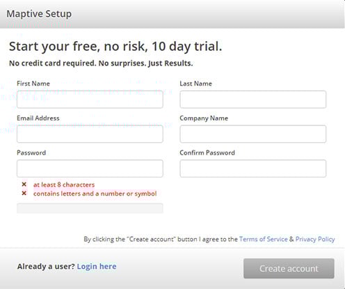
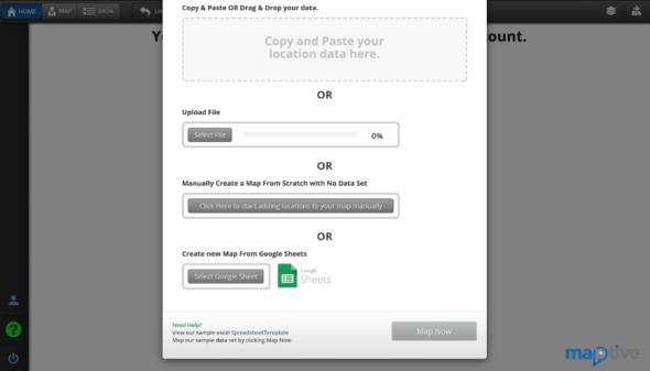
Step 1: Sign Up for Our Free Trial: The signup process is simple (no credit card details are required) and allows you to try our software risk-free.
Step 2: Create Your First Map: Once you’ve signed up, click “Create My First Map.” Choose a name for your map, then click “Continue” to start building.
All the Tools You Need to Create the Map You Want
Maptive’s comprehensive set of mapping tools give you the power to create any map you want. Here are some of Maptive’s key features and tools:
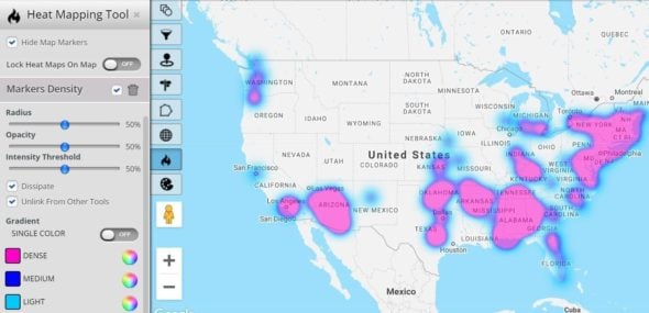
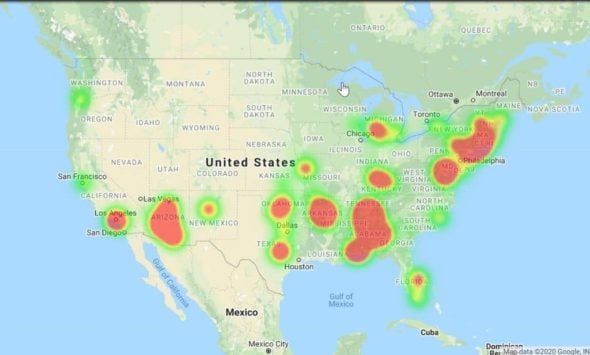
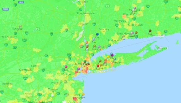
Heat Mapping Tool
Heat mapping is one of the best mapping software tools available and allows you to understand market density within a map’s vicinity instantly. Our heat maps are fully customizable, letting you adjust the look and feel of your visualization. You have the option to adjust the opacity, radius, intentional threshold, and gradient colors of the targeted areas to create the perfect heat map.
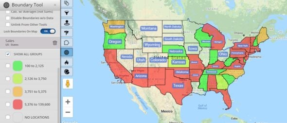
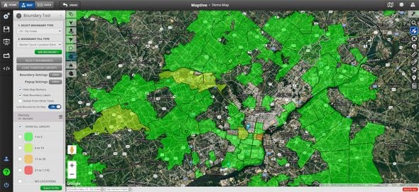
Boundary and Sales Territory Tools
Maptive’s boundary and territory tools visualize territories based on areas such as cities, states, or zip codes. Draw custom territories if the pre-set boundaries do not meet your needs. You can also add secondary criteria such as population, demographics, or average income to understand trends further or identify opportunities. This mapping tool is ideal if you want to understand the market in a particular area quickly.
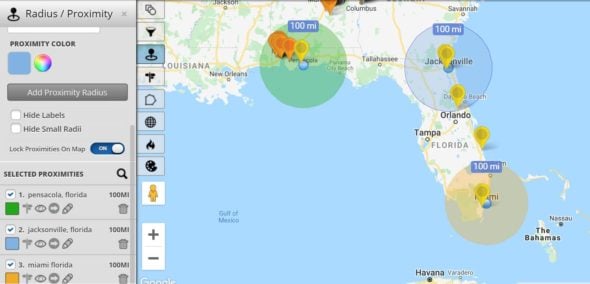
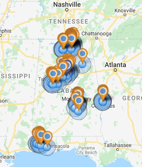
Distance Radius Tool
Use our map drawing software to illustrate a radius of a particular number of miles or kilometers around a central location. This will allow you to quickly run a proximity analysis on any segment of your location data. In addition, you can pull demographic information and metrics from your data for the radius area. Lastly, you can choose to export data within a stipulated radius.
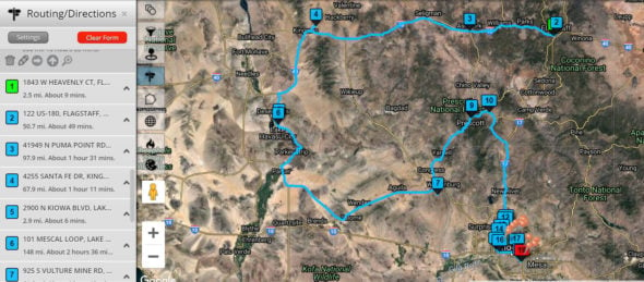
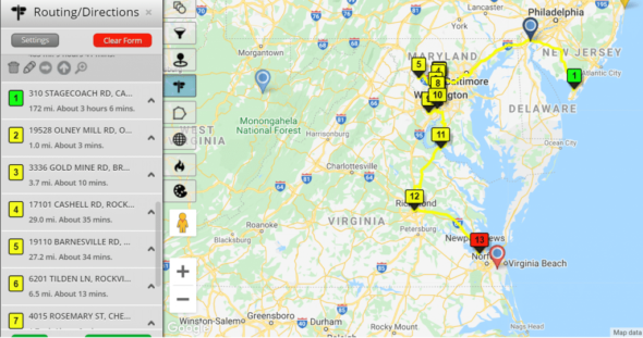
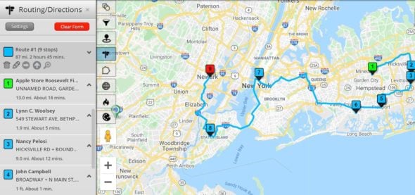
Route Planner and Optimizer
With the help of our route planner tool, you’ll be able to quickly determine the most efficient route to take between two or more locations. You can plan routes between any locations that already exist on your map or manually load relevant addresses. The tool is fully customizable and comes with a drag and drop feature that allows you to make changes on the fly.
Click here to learn about our many other mapping tools.
What Type of Map Do You Need to Create?
Maptive’s wide range of tools and features means you can create a number of different custom Google maps to suit your project. Here are a few of the most common types of maps that are utilized by our clients:
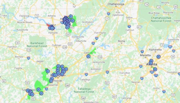
Sales Density Maps
Quickly identify where your highest number of sales are coming from and what regions have room for improvement. Map out your customers to identify hot spots to target your sales & marketing efforts better. Use your data to identify new markets combined with Maptive’s included data sets, including demographics and census data.
Demographic Heat Maps
You can use demographic heat maps to visualize the distribution of a variety of data, such as population, income, sex, and marital status in a given region.
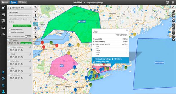
Territory Maps
Easily divide your map into multiple territories using predefined data, such as sales territories or zip codes. You can then analyze data, such as sales and demographics, within each territory.
Pin Maps
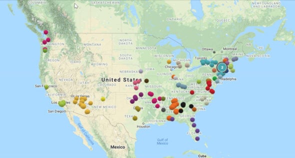
Pin maps are a great way to quickly plot location-based data on a map. You can use these maps to plot addresses, business locations, customer locations, and more. If desired, assign your pins different colors based on your data.
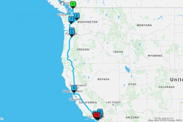
Route Maps
Plan the most efficient route between two locations and identify geographic data points that are in close proximity to your specified route using the route planner tool.
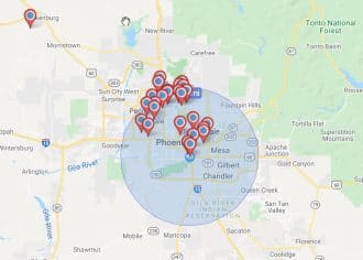
Radius Maps
Create distance radiuses around specific data points to gain additional insights. You can analyze your data within a radius, export data points, and draw on census data within the radius.
Common Use Cases
Here are a few real-world examples of how our mapping software can help you grow your business and reach your goals:
Commercial Real Estate
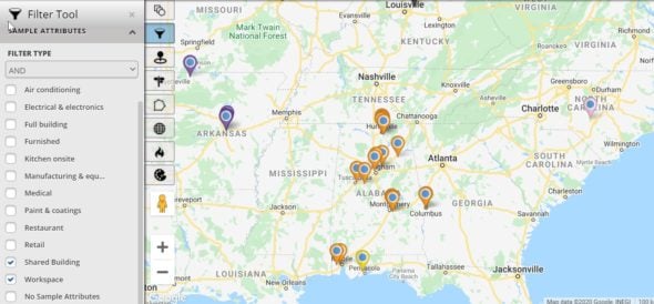
A commercial real estate broker wants to be able to show prospective buyers available properties and get a visual understanding of a property’s surroundings for site selection or investment purposes. By plotting all current or proposed listings on a map, along with their attributes and amenities, the broker can use the filter tool to analyze a property and select the features most important to a specific buyer. This allows them to only display properties that meet the buyer’s requirements. In addition, leverage our connection to Google places data to find out exactly what is close to a proposed location (competitors, public transit, shopping, etc.).
Sales
Sales teams often want to see a visual representation of where their sales are coming from, define sales territories, leverage census information to drive additional sales, or use heat maps to better understand sales density. Maptive helps teams gain these visual insights, saving time, and boosting sales.
Supply Chain/Logistics
Wouldn’t it be easier if you could visualize your entire supply chain, identify and improve inefficiencies, and determine the quickest routes to make sure customers are receiving their products in as little time as possible? Our supply chain mapping software lets you plot all the locations involved in your operation, spot the weakest links in your network, and find the quickest route between multiple locations.
Ready to Uncover New Insights with Beautiful Interactive Maps?
Sign up for a free trial of Maptive today and see where our mapping software will lead you.
Try Maptive Risk Free