Best Alternative to Microsoft MapPoint
Maptive picks up where Microsoft MapPoint left off with a modern, cloud-based platform you run from any browser, powered by Google Maps and kept current for you.
No credit card required
- Cloud replacement, actively maintained
- Works in any browser, on any device
- Current Google maps and live data
- Business mapping with real support
Trusted by teams at


Why You Need a MapPoint Replacement
Microsoft shipped MapPoint as desktop software in 1999, released the last version in 2013, and ended support after December 31, 2014.
MapPoint was a Windows desktop product, so it stopped getting new maps, fixes, and features once Microsoft retired it. The road data ages, the install ties you to one machine, and a new laptop or operating system can leave you without a way to open your old work. Discontinued software quietly becomes a liability.
You still have addresses, customers, and territories to map, and you need a tool that is current and supported. Maptive picks up where MapPoint left off with a cloud platform on Google Maps, so your maps stay accurate, you reach them from any device, and a real team is there when you have a question.
The Maptive Advantage
A modern, supported home for the work you used to do in MapPoint, in one browser-based platform you can use on day one.
| Capability | What Maptive Delivers |
|---|---|
| Actively Maintained | Maptive is a current, supported product, not retired software. Updates ship in the background, so you always have the latest tools and accurate maps with no reinstalls, no version transfers, and nothing to patch yourself. |
| Cloud, Any Device | Runs 100% online in the browser across Mac, Windows, iOS, Android, Chromebook, and tablets. There is nothing to download or install. Log in from any device and your maps are right there, where MapPoint tied you to one Windows PC. |
| Powered by Google | Built on Google's enterprise mapping technology, with global coverage in over 214 countries, current satellite imagery, Street View, and live traffic. Map data refreshes on its own, so what you see stays accurate. |
| Focused and Easy | Maptive keeps the tools people actually use and leaves out the clutter, so the learning curve is short. Upload a spreadsheet, click Create Map, and your locations land on an interactive Google map in seconds. |
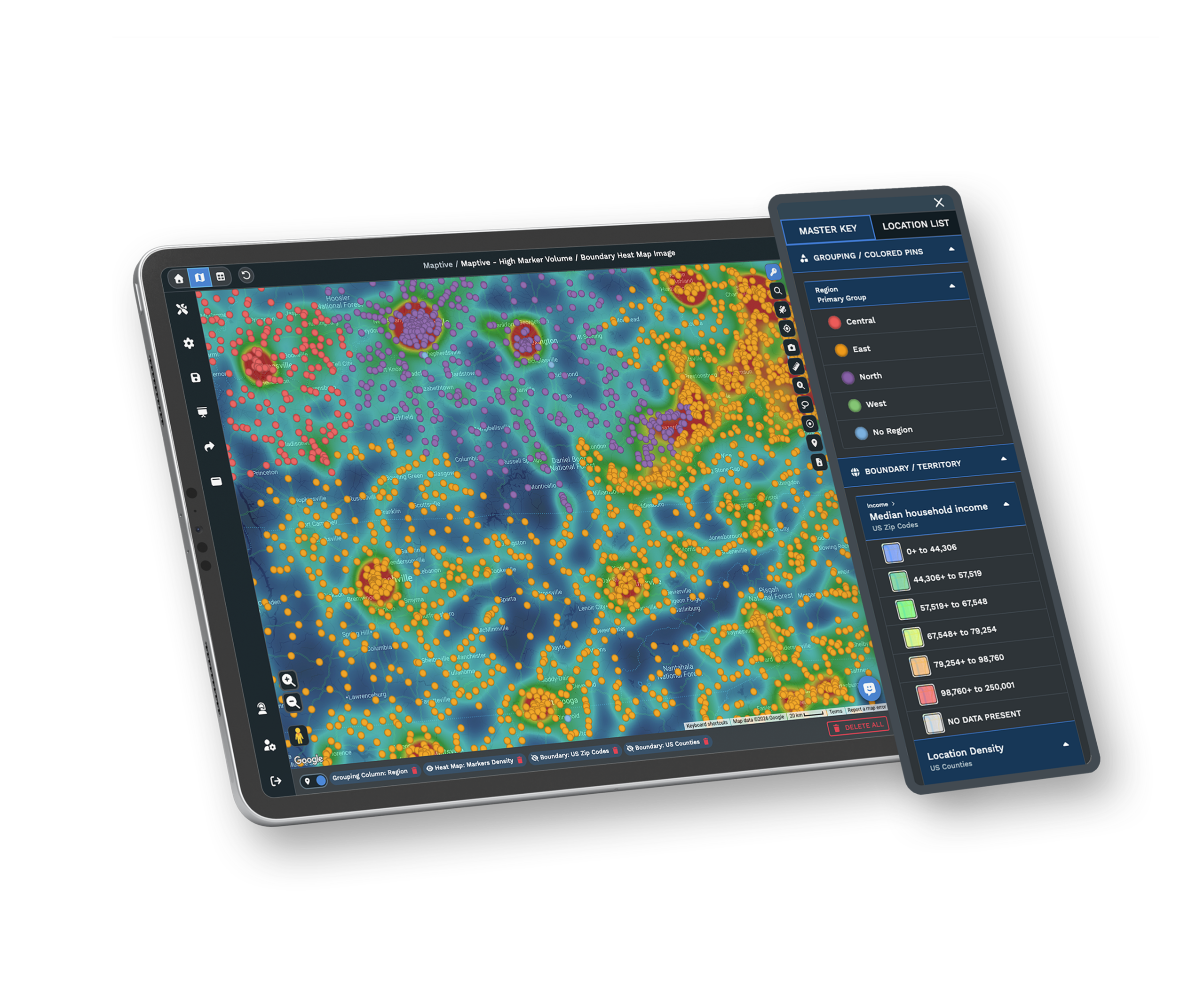
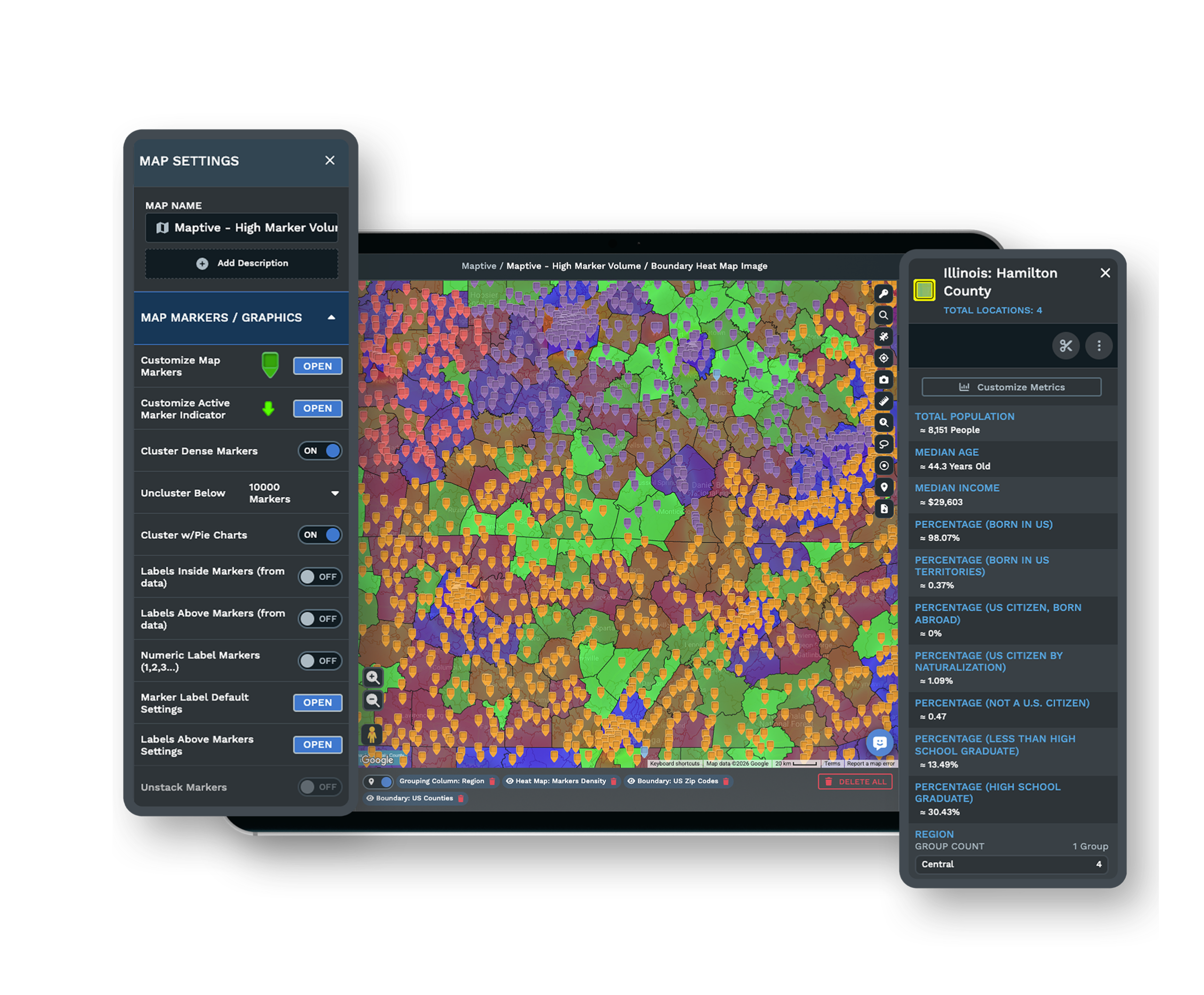
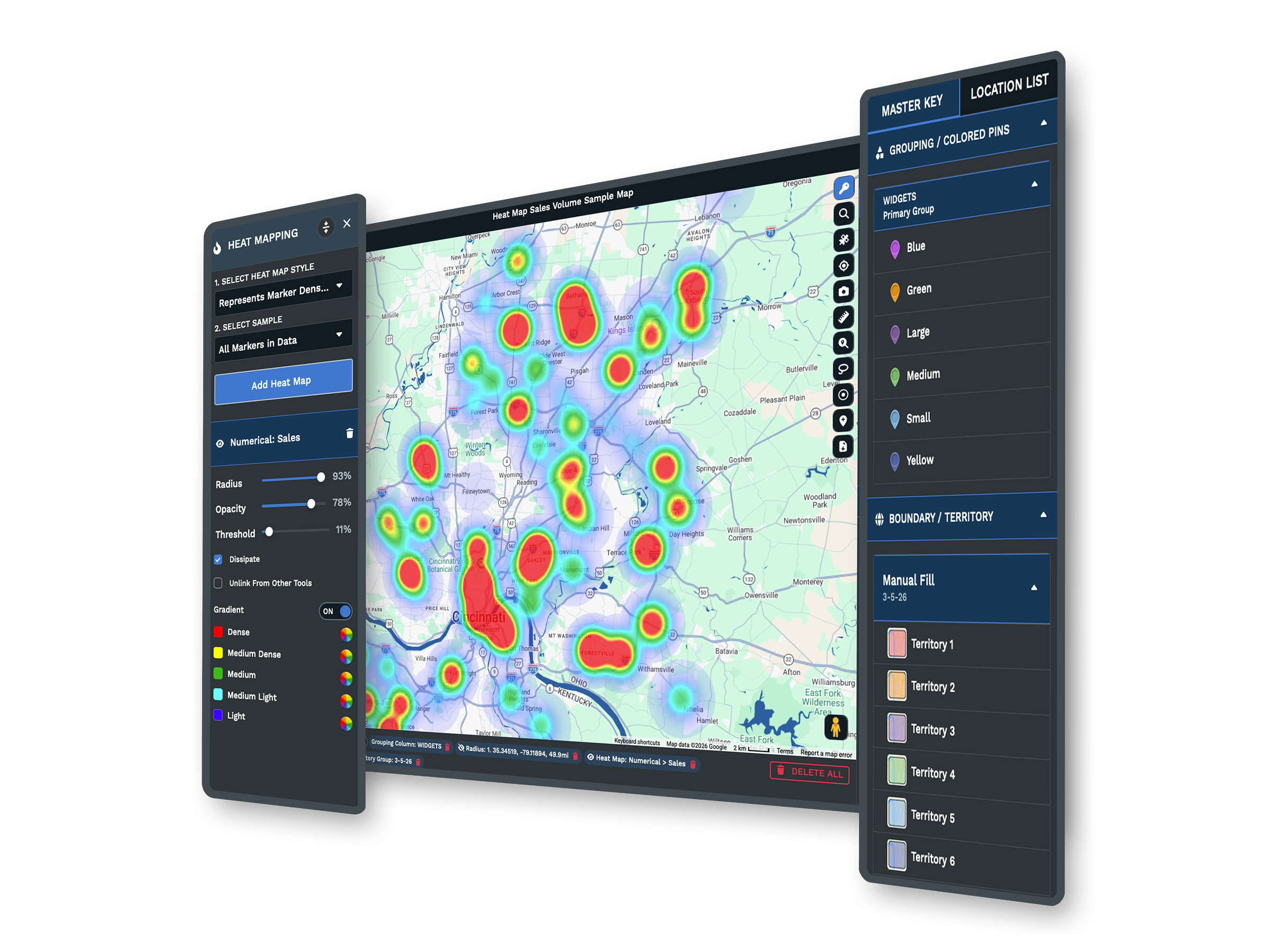
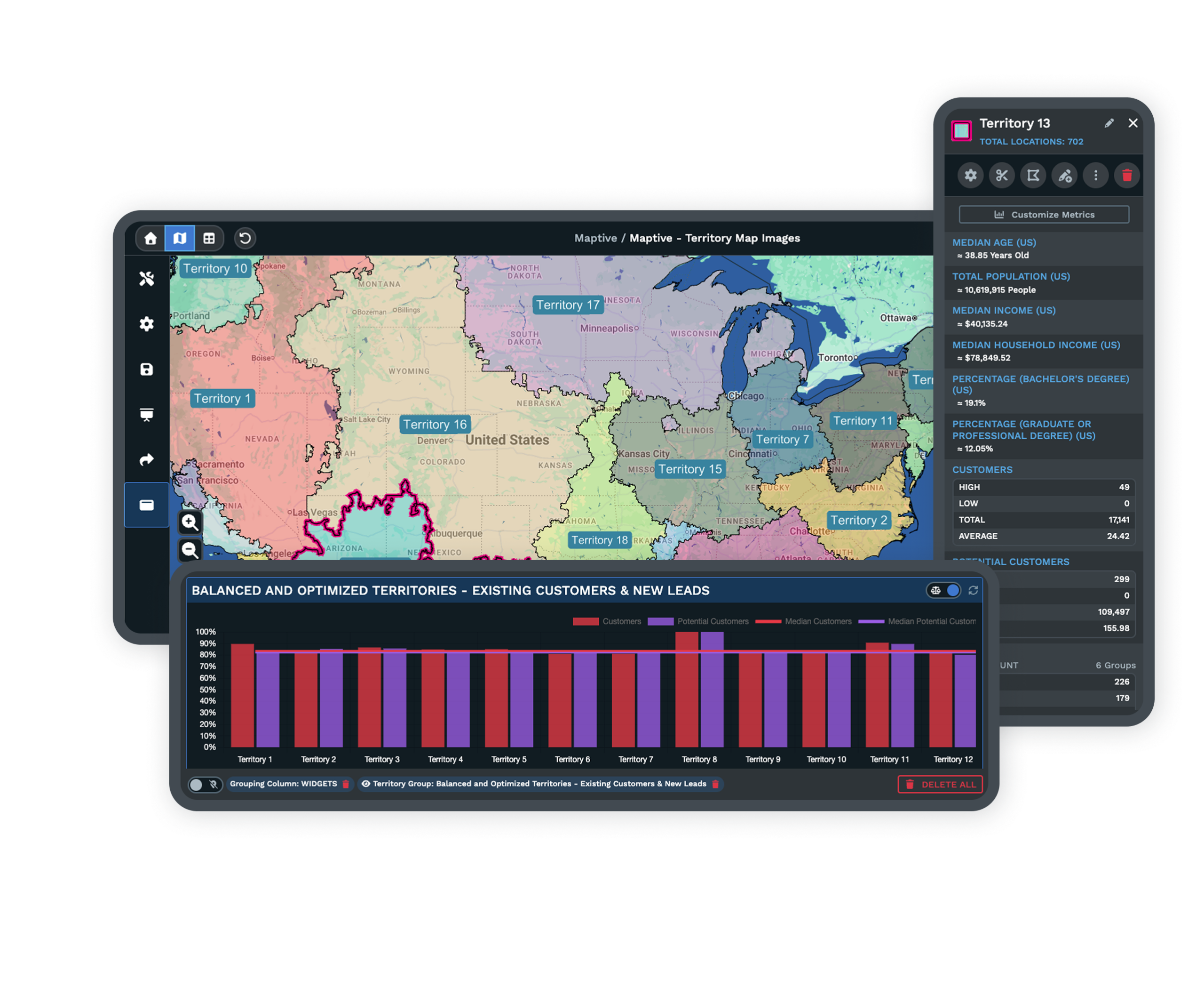
| Business Tools | 60+ tools cover the work MapPoint handled and more: territory drawing, route optimization, drive-time and radius areas, heat maps, marker grouping, filtering, boundaries, and demographic overlays with census data. |
| Fully Customizable | No two Maptive maps look alike. Change colors, fonts, opacity, line thickness, and density thresholds, restyle the base map, and upload your own markers. The map is your canvas, built to match how you want to present it. |
| Share and Export | Getting data out is as easy as getting it in. Share a map by secure link, embed it on your website, export your processed data back to a spreadsheet, or print a poster-size version for the wall. |
| Real Support | A 30+ person team in the US and Canada answers by live chat, phone, and email on every plan. Most people hear back in under 15 minutes, and data imports and file cleanup are included. G2 rates support 9.7/10. |
A Cloud Platform That Never Goes Out of Date
MapPoint stopped where Microsoft left it. Maptive keeps moving. Because it runs in the browser, every update reaches you automatically, the maps stay current, and you skip the reinstalls, firewall conflicts, and license transfers that come with desktop software.
There is nothing to download and nothing to maintain. Open a browser on a Mac, PC, Chromebook, or tablet, log in, and your maps are ready. A new laptop or operating system will not strand your old work the way a retired desktop tool can.
Turn a Spreadsheet Into a Map in Seconds
Maptive was built with the user in mind, so you spend less time deciphering the how and more time on the what. Copy and paste your data, drag and drop a file, or upload an Excel spreadsheet, then click Create Map and your locations appear on an interactive Google map.
The powerful analytics tools are there when you need them and out of the way when you do not. Color-code markers, filter records, draw territories, map drive times, and build heat maps without hunting through cluttered menus. If you can use a spreadsheet, you can use Maptive.
Maps You Are Proud to Share
A map is only useful when other people can see it. Every element of a Maptive map is yours to adjust, from colors and fonts to marker styles and density thresholds, so it matches your presentation, your website, or your team meeting.
When the map is ready, share part or all of it with colleagues and clients by secure link, embed it on your site, export your processed data back to a spreadsheet, or print a large version for the office. Getting your work off the platform is as easy as getting it on.
The Tools That Replace MapPoint
The features people reached for in MapPoint, rebuilt on Google Maps and ready the moment you sign in.
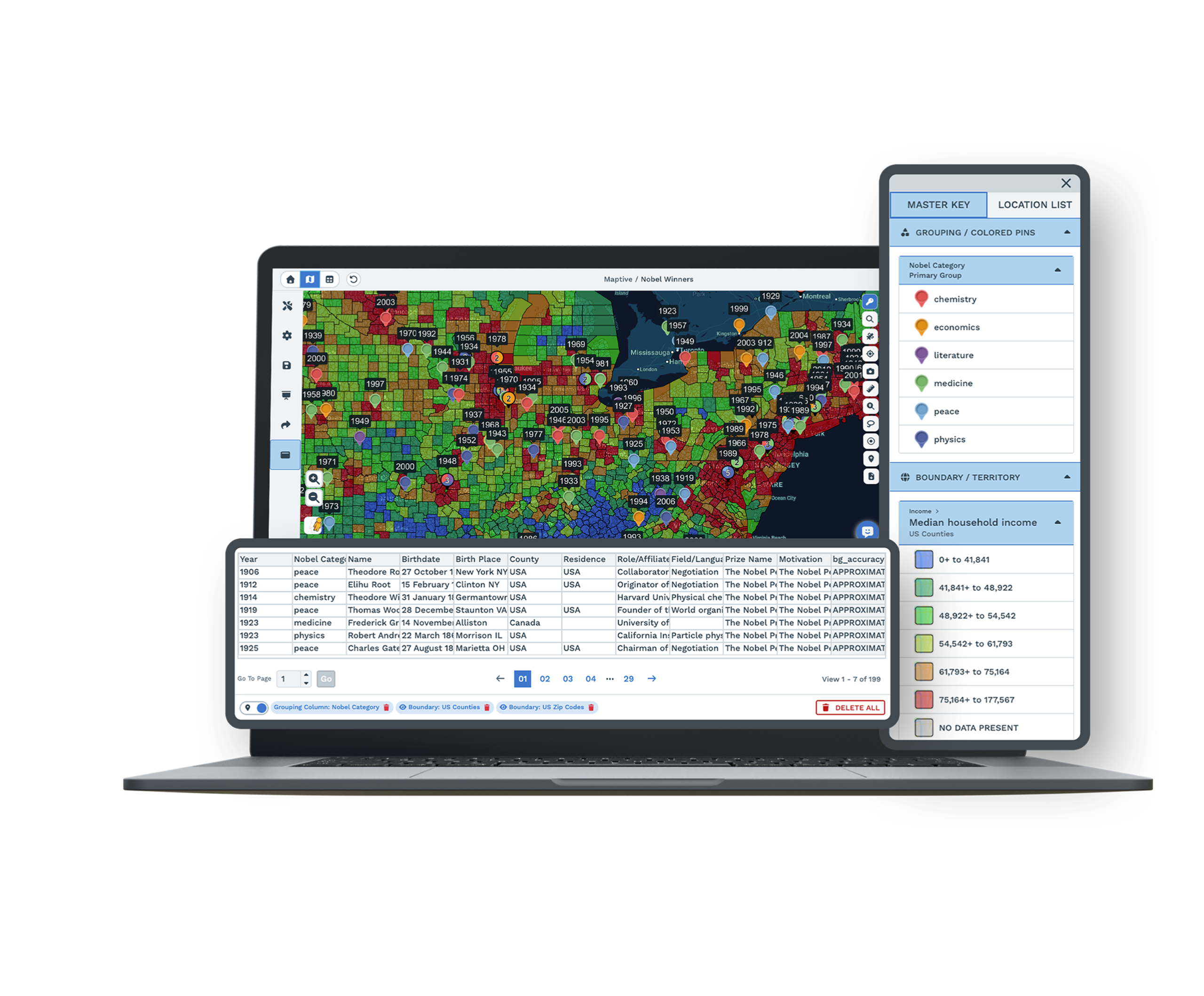
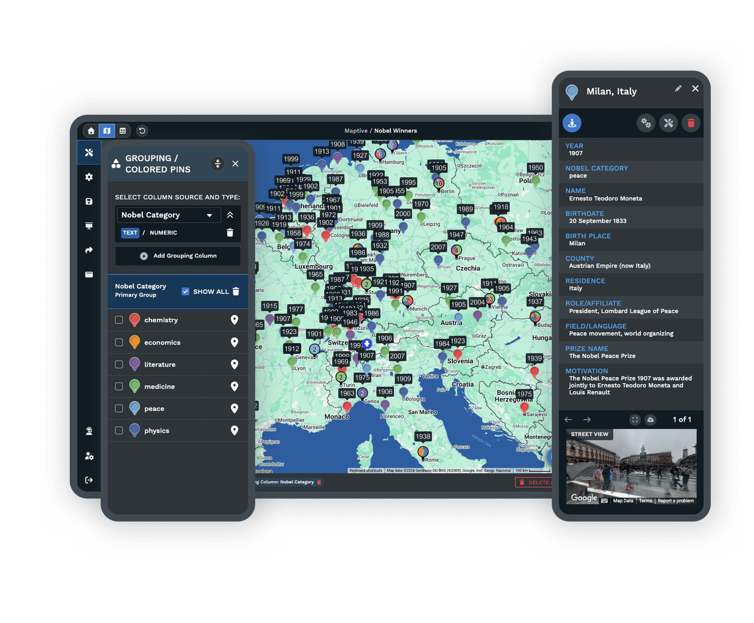
Grouping and Filtering
Color-code markers by a category in your spreadsheet, then filter to show only the records you want. Read patterns in your data at a glance.
Radius and Drive Time
Map distances from a central point and see how far a team can travel within a set drive time, measured in hours and minutes.
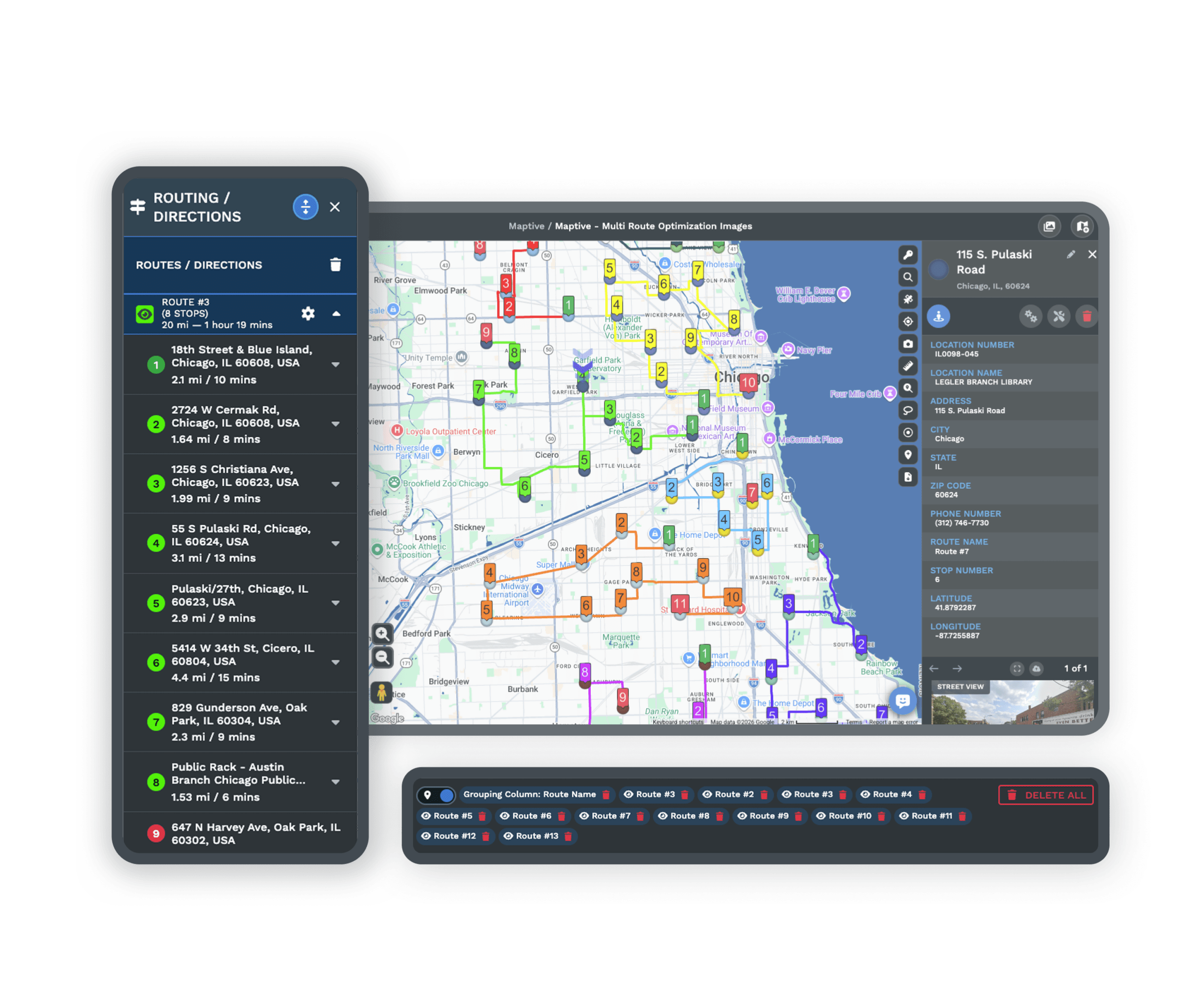
Routing and Directions
Map multiple stops and optimize the order, then export turn-by-turn directions to a phone so drivers never lose the route.
Territories and Boundaries
Draw custom territories or build them from counties, states, and zip codes, then pull census data into any area to compare them.
Heat Maps
Turn raw numbers into a clear heat map of density and opportunity, with no manual work and a presentation-ready result.
Drawing Tool
Make a map easy to read by adding labels, arrows, icons, and shapes, so it tells a clear story in a report or a client deck.
MapPoint Alternative FAQs
What happened to Microsoft MapPoint?
Is Maptive a good replacement for MapPoint?
Do I need to install Maptive like I did MapPoint?
How is Maptive powered by Google Maps?
How easy is Maptive to learn?
What kind of data can I import into Maptive?
Can I customize the look of my maps?
How do I share or export a Maptive map?
How much does Maptive cost compared to MapPoint?
What support does Maptive offer?
Free trial, every tool, no credit card
The MapPoint Alternative You Have Been Waiting For
Start a 10-day free trial with no credit card and every tool unlocked, or book a demo and we will set it up around your data. Upload a spreadsheet, click Create Map, and most people build their first map in under five minutes.
Switching From MapPoint?
Bring your address lists and spreadsheets straight over. A specialist walks you through setup and helps with imports and file cleanup, so you are mapping again in your first session.

