Isochrone Maps
Use isochrone maps to quickly determine the travel time between multiple locations, or find locations that are reachable within a certain timeframe. Maptive’s wide array of tools make it easy to quickly create these and other types of interactive maps.
What is an Isochrone Map?
Isochrone maps contain lines that represent the intersection of points on a map that share some equal property. For example, a map that contains points that represent the distance from a certain starting point that can be travelled in a certain period of time. ex: How far can you commute from your house in 1 hour
Since Francis Galton published his first isochrone map in 1881, since then they’ve been primarily used for travel. However, they’re utilized in other ways as well. For example, scientists use them to measure the time it takes runoff water to reach lakes.
Isochrone maps come in many different variations, making them perfect for a wide range of projects.
What Can You Use Isochrone Maps For?
Some applications for isochrone maps include:
- Finding the travel time between two locations.
- Calculating how far you can travel in a certain period of time from a starting location.
- the
- Discovering which locations are reachable from a point on a map within a certain timeframe.
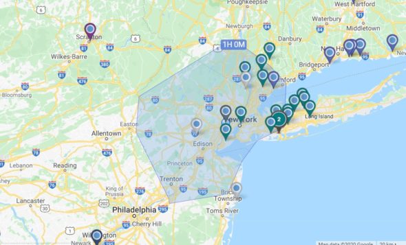
Let’s say you’re in London, England and you have 45 minutes to potentially drive somewhere else. An isochrone map will instantly show you the furthest distance you can travel in every direction within that time.
Another application is for people who are considering buying a home. They’ll likely want to know what shops and services are within driving distance, or if they’ll have a reasonable commute to work.
Many isochrone maps can be adjusted based on whether you’re walking, using a bicycle, driving, or taking the subway, giving you accurate measurements based on your preferred means of travel.
Limitations of Isochrone Maps
Isochrone maps deal strictly in time, not distance. This means that if you need to record the distance you travelled during your trip (recording your gas mileage for a business trip, for example) you’ll need to use another tool, such as an isodistance map.
Most isochrone maps will show you possible routes, but they might not show you the optimal route, so keep that in mind as well.
Finally, drive times are always changing based on current traffic conditions, so the information you receive might not always be accurate. While an isochrone map service like Google Maps will give you up to date travel times based on traffic, if you’re planning your trip in advance you’ll need to take this into consideration.
For example, if you’re going to Paris, France and want to look up the drive time between the Eiffel Tower and the Notre-Dame Cathedral, the results you get on Sunday afternoon will likely be different than on a Wednesday at 5 pm.
How to Calculate Drive Time or Travel Time in Maptive:
Powered by Google Maps’ API, Maptive’s drive time polygon tool is a sophisticated type of isochrone map that will instantly tell you the reachability of various locations within a certain amount of time.
Follow the steps below to create an isochrone map:
Step 1: Sign up for a Maptive free trial account. Try Maptive for free and explore the many mapping tools we have to offer.
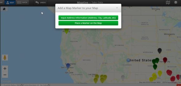
Step 2: Upload or input your data. You can upload data directly from an existing Google or Excel spreadsheet, copy and paste your data into Maptive, or enter it manually.
Step 3: Select “Create Map” to view your map. Maptive will plot your data on an interactive map.
Step 4: Open the drive time polygon tool. Click the tools icon in the upper lefthand corner, then select “Distance Radius / Drive Time Polygon Tool.”
Step 5: Set your parameters and create your polygon: Under “Type” select “Drive Time Polygon.” Next, enter your location and your desired travel time in hours and minutes. When you’re ready, click “Add Drive Time Polygon.”
Start Your Free, No Risk, 10 Day Trial
No credit card required. No surprises. Just Results.


