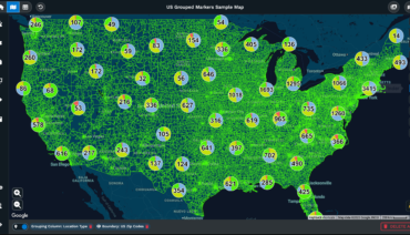
Maptive iQ provides delivery planners with accurate drive time mapping. It includes many tools for route optimization, territory assignment, and data export. The most recent updates bring more precision, faster workflows, and new options for collaboration. Planners can work together from different sites without delays or errors.
Table of Contents
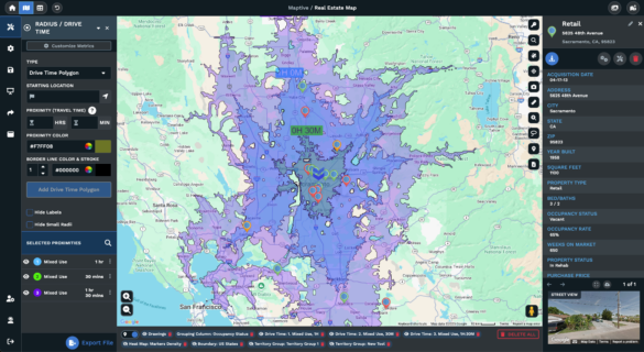
Drive time polygons in Maptive iQ are now accurate up to four hours. The system determines travel boundaries from a location based on average speed limits in ideal conditions. Increased calculation points give each polygon smooth, detailed edges. This gives delivery planners more accurate boundaries around store locations, depots, or customer addresses. Route planning and delivery zone creation become precise and easy to check at a glance.
For example, setting a two-hour drive time polygon gives planners all the locations reachable by ground in two hours under realistic driving conditions. It prevents overpromising delivery windows and shows when another depot or distribution point is required.
You can add as many proximity drive time areas as you need. Each one can have a different color, opacity, and name. For multi-site companies or chains, this speeds up territory management. Each store location can have its own custom drive time proximity. You can compare zones visually and adjust their settings easily.
Editing and customizing these polygons is straightforward. Users click the pencil icon in the Proximity Tool list, which brings up edit options for name, color, and opacity. All updates appear on the map once saved. Renaming polygons clearly prevents confusion among planners and drivers.
Proximity polygons can be selected one at a time or grouped for export. You can export location data from one or all polygons. Supported export formats include common spreadsheet files such as xls, xlsx, csv, and tsv. This supports offline planning, auditing, and communication with staff in the field or with partner systems.
Maptive iQ keeps map creation simple. The following steps show how to add a drive time polygon:
Maptive iQ allows extra customization for each proximity polygon. You can click inside any polygon to see its popup and choose “Customize Popup.” Alternatively, use the Popup Settings OPEN button in the tool window. Planners who want minimal map labels can hide proximity labels by checking a box in the tool’s window.
Each proximity has export controls. Clicking the export button for a polygon gives file outputs for that one zone. The tool also has a green export button at the bottom, which exports every mapped location within every polygon in one step.
The Maptive cloud platform supports team projects. Multiple users may edit the same map at once, enabling remote site management. Audit trails record who made each change, improving quality control. Managers assign or withdraw access to any map with a click. This protects confidential delivery plans and prevents editing errors with minimal effort.
Teams working together are less likely to create overlapping zones or miss critical locations. Each update appears for all users. New users can be onboarded quickly, with no lag between changes.
The split-screen feature lets users see live map updates side by side with linked business data. A dispatch manager can propose a territory change, then check on-screen how it affects routes, workloads, or assignments. The split-screen supports step-by-step changes, training new employees, and catching errors before finalization.
Maptive iQ includes flexible API features for advanced cases. Technical users can pull live geographic data into internal dashboards, scheduling tools, or sales summaries. This has become important for retail groups needing to compare competitor clusters and sales patterns. By matching highlighted sales zones to changing business trends, planners set realistic delivery goals and optimize their driver coverage.
With Maptive iQ, realignment of delivery zones takes place in minutes. Before, adjusting a territory could require an entire day due to manual checks. Automatic notifications now flag any affected records immediately. Mistakes or oversights are reduced.
The update brings unified tools to create territories from mapped boundaries. Planners may use state or county lines, draw custom lines, or import previously saved files. These boundaries can then become polygons, with full export and edit functions. This removes the need for repeating the same edits and saves time for staff managing large delivery networks.
For 2025, Maptive iQ plans to include a scheduled offline mode for projects. This feature helps users who need to work with maps while away from reliable internet access. There will also be expanded package options directed at researchers and statistical users, supporting advanced delivery studies and planning.
Maptive iQ includes route optimization for delivery runs. Sophisticated algorithms check all possible delivery routes, then select the fastest and least costly option. The program considers traffic delays, standard closures, and time of day. Drivers get realistic, achievable plans and customer time windows stay accurate. Real-time adjustments allow dispatchers to respond to road conditions or emergencies as they occur.
Planners see multiple options and can try out edits with live maps. This supports faster scheduling for new deliveries or rescheduled jobs. Route planning tools carry over improvements from the latest updates, including faster calculations and more reliable export tools.
Exporting mapped data is simple. Each proximity polygon, drive time area, or territory may be selected for export on its own. Planners can send all zones to a file with a single selection. This allows simple integration with business reports, schedule printouts, or external planning tools.
Export formats include xls, xlsx, csv, and tsv. These are popular choices for most route management platforms and allow planners to use data offline or in outside systems needed for payroll or customer reporting.
Maptive gives users fine control over how their maps appear. The popups inside each drive time polygon can be edited to show only the most useful data. This can help limit distractions for delivery drivers or new staff. With one click, planners can remove excess labels for a cleaner, faster map. Setting custom colors or opacity for polygons makes routes easier to read and prevents staff confusion about overlapping or touching boundaries.
Changing these settings takes a few steps. Users click the pencil icon for a polygon, which opens the customize menu. Name, color, and opacity all update from this menu. Any change is reflected live on the main map.
For larger organizations, Maptive iQ supports fine-grained project management. Administrators assign or remove access to any map at any time. User history logs protect against accidental edits or lost work. These controls let a planning department review changes and correct them instantly if required.
This model improves security and protects confidential customer locations or scheduling data. Each action is tracked, so no edit goes unnoticed.
The updates planned for the next year focus on field flexibility. Offline mode will be important for delivery planners on the go. New tool packages for research teams will support custom analysis and scanning of drive time polygons or delivery paths. These improvements come on top of regular upgrades to calculation detail, export options, and collaborative features.
Maptive iQ gives delivery planners practical tools for building, adjusting, and sharing precise drive time maps. The system provides fast calculations, flexible export, cloud collaboration, and deep customization options. Planners and managers can review all mapped zones, customize boundaries, and control who edits each project. Real-time data, split-screen functions, and API integrations support integration with retail, sales, and delivery platforms. Advanced features such as route optimization and planned offline mode prepare teams for any delivery planning challenge.
Cloud sharing, exportable data, and user-friendly controls make Maptive iQ a strong choice for any company needing full control of delivery territories and time-based routing. These features combine accuracy and efficiency with a smooth workflow for any size or type of delivery operation.
Brad Crisp is the CEO at Maptive.com, based in Denver, CO and born in San Francisco, CA. He has extensive experience in Business Mapping, GIS, Data Visualization, Mapping Data Analytics and all forms of software development. His career includes Software Development and Venture Capital dating back to 1998 at businesses like Maptive, GlobalMojo (now Giving Assistant), KPG Ventures, Loopnet, NextCard, and Banking.