Create Professional Maps with Our Easy-to-Use Map Maker
Achieve professional data visualization in business presentations with ease.
Give your sales and marketing teams the tools they need to succeed with heat maps and territory optimization.
Use powerful business insights to make strategic decisions that save money and open up new opportunities.
Streamline data analysis and communication to improve overall efficiency and productivity.
Maptive is a professional map making software that can help businesses, organizations, and individuals create high-quality interactive maps for presentations, marketing materials, real estate, and more.
With Maptive’s user-friendly, no-code software, creating a professional and customized map is a breeze with just a few simple steps:
Step 1: Log in to Maptive and either create a new map or choose one from your existing maps. All new users can start with the free version.
Step 2: Access the Map Settings and choose from a variety of templates or customize the map using different objects, colors, and settings.
Step 3: Utilize the Advanced Settings to enable, disable, or adjust the appearance of any map elements, including points of interest, roads, highways, water, land, and more.
Step 4: Share your newly created map by displaying it in your presentation, or document, or embedding it on your website and witness the results!
Maptive is designed to be intuitive and user-friendly, and, most importantly, it requires no coding knowledge to produce a professional custom Google map. Some of the most used features include:
Map Maker Features
Map Customization
With Maptive, you can add as many details as you need to illustrate crucial business insights on your online map. Draw shapes and highlight specific areas that are important to your business, or add text and create icons, enhancing the overall clarity of your map and providing an easy way to convey important information. Color and opacity settings can help create emphasis and contrast, helping to guide your audience to the most important aspects of your custom map.
Easy Data Upload
Maptive allows you to import your data in a variety of formats. Whether your location info is in Excel, CSV, Google Sheets, or your own CRM, or you want to copy-paste and enter the data individually, Maptive makes it easy to upload what you want to your custom maps.
Layer Multiple Maps
With just a click of a button, you can combine two or more detailed maps (data sets) into a single, aggregated map image. This feature allows you to view each layer (data set) independently or in combination with other layers, providing you with a comprehensive view of your data.
Grouping Tools
Make sense of large amounts of data with Maptive's Grouping Tools. Easily categorize and customize markers, and filter them for quick retrieval when you need to create your next interactive map.
Driving Intelligence Tools
Optimize your operations with Maptive's Driving Intelligence Tools. Use the Driving Radius Maps and Drive Time Polygon Tools to track reach and make strategic decisions about where to expand your business. These are some of the more unique and helpful mapping tools at your disposal from your custom map maker.
Demographic Data
You can enhance your understanding of potential new locations with access to the latest U.S. Census Demographic Data available in Maptive's mapping software. Get insights on population density, median household income, education, and more to make informed decisions for your sales and marketing strategies.
Map Types
Maptive's mapping software saves businesses and organizations time and resources by streamlining the creation of interactive maps that multiple users can collaborate on, unlike Google Maps or any other free tool and map making solution. Here are some of the map types that our map maker users love:
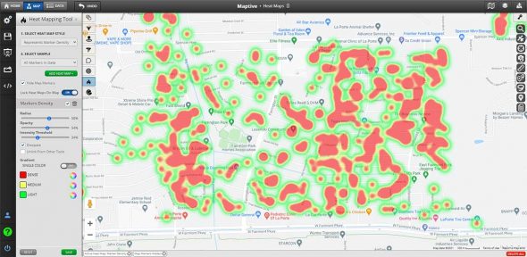
Heat Maps
You can use your existing location data to easily create heat maps that identify areas of success and potential new business locations. Pinpoint hot spots and cold spots to make informed decisions.
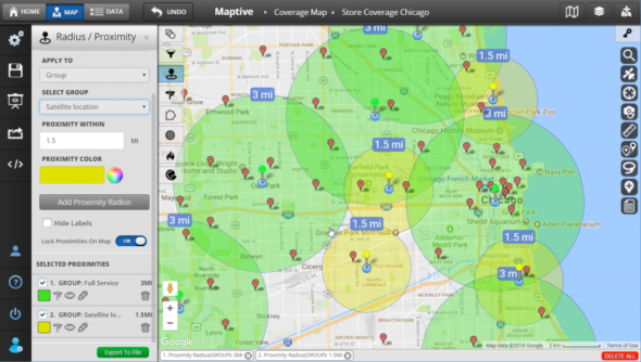
Radius Maps
Conduct a proximity analysis on your location data quickly and easily. Maptive enables you to create multiple radius circles and fully customize their appearance, so you can easily pinpoint areas of high and low concentration and make data-driven decisions to improve your business results.
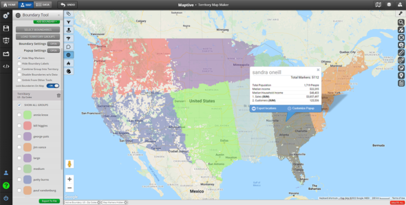
Territory Maps
Say goodbye to the guesswork in Google Maps and improve your sales process with Maptive’s AI algorithm. Territories are divided based on key metrics such as sales numbers, geographical boundaries, and market size, allowing you to assign accounts to salespeople with confidence and support revenue growth.
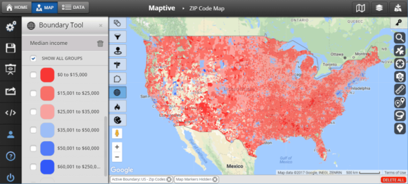
Zip Code Maps
Use zip codes to easily track your sales team’s performance and identify key trends. Want to expand your target area beyond zip codes? Maptive allows you to define larger geographical boundaries such as counties, cities, and states so you can create maps for a more comprehensive analysis.
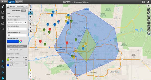
Driving Radius Maps
Maptive’s mapping tools include our Distance Radius/Drive Time Polygon Tool, which allows you to easily draw radius circles around any location, determine distances between points, and customize the appearance of each radius. You can add multiple radii, export data, and edit the name, color, and opacity of each radius.
Benefits of Using Maptive
Save time and resources while producing professional looking maps! With Maptive, you can create maps that are tailored to your specific needs, whether it’s for a presentation, marketing campaign, or real estate listing.
Make Your Data Work for You
With Maptive’s map maker software, you can easily plot multiple locations on a world map using various data types such as addresses, zip codes, and coordinates to best fit your business needs.
Uncover Critical Business Insights
Maptive empowers users to make data-driven decisions by providing powerful insights through data visualization, heat maps, and territory optimization. Interactive maps can unlock cost savings and market opportunities to take your strategy to the next level.
Make Your Maps Unique
With Maptive’s user-friendly, no-code platform, users can easily customize their maps to fit their specific needs and preferences. Choose from a wide range of map styles and elements, including customizable markers, and select your favorite view, including satellite, topographical, and black-and-white world maps, to make your visualization truly stand out.
Share. Print. Embed
Share maps in one click and stay in control of the privacy settings for each map. You can make them publicly discoverable, or only accessible by the right people. With Maptive, users can embed a fully interactive map on a website with one line of HTML code; or export and print uniquely branded and customized maps with the ability to make it as large as a 2048 x 2048 pixel poster.
Ready to Become a Professional Map Maker?
Maptive’s user-friendly, no-code platform allows you to optimize your maps with ease. Choose from a wide range of customizable map styles and tailor your map elements to best showcase your information. Utilize our library of markers or upload your own images to create a perfectly polished, professional visualization every time.
Start Your Free, No Risk, 10 Day Trial
No credit card required. No surprises. Just Results.


