Create Maps with Maptive
Create maps that are bespoke to you and your business in just a few simple clicks.
Change the colors of each element on your map, add unique icons and markers, set preferred text colors and styles, and pick which map features are enabled. All of that–and more!–without having to write a single line of code.
- Create custom maps
- Easily share and export maps
- 100% cloud-based
- User-friendly
- Fully integrated with Google Maps
Create Custom Maps with Maptive
- Impress your audience with stunning data visualizations for your business presentations.
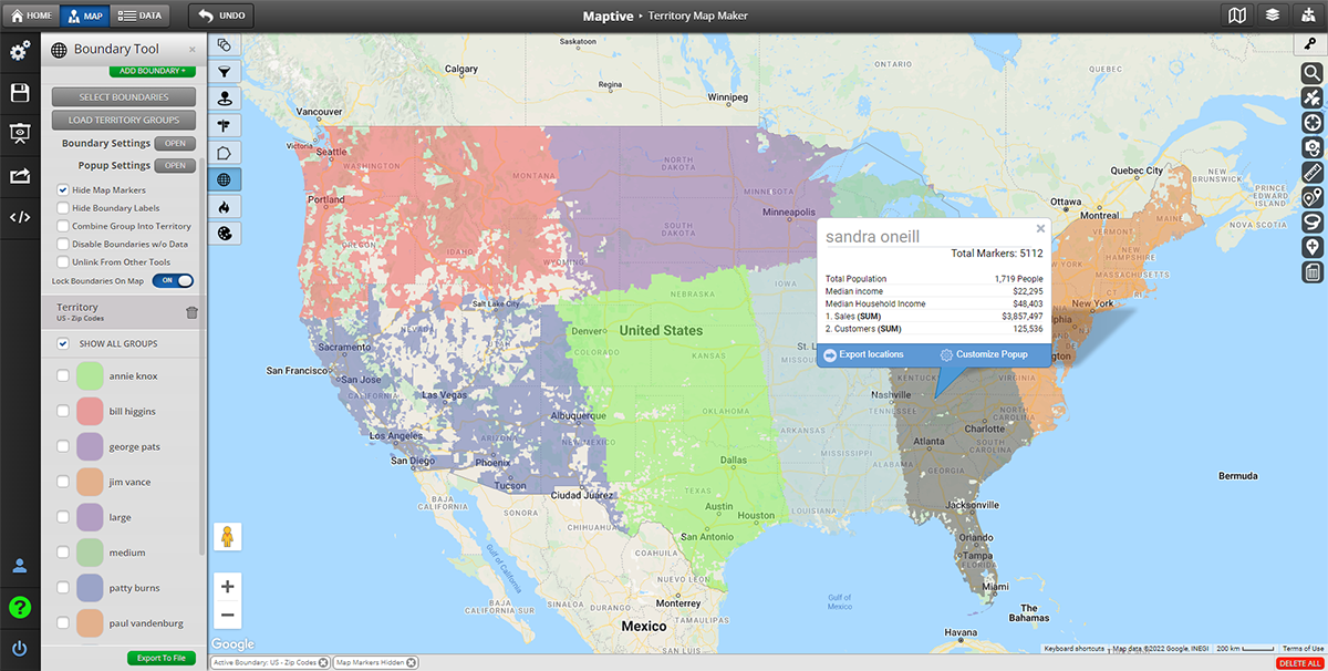
- Equip your sales and marketing teams with helpful tools like heat maps and territory optimization to boost their performance.
- Unlock valuable business insights that can help you reduce costs and expand into new markets.
- Improve your workflows by analyzing and sharing information with ease.
An Overview of Maptive's Features and Benefits
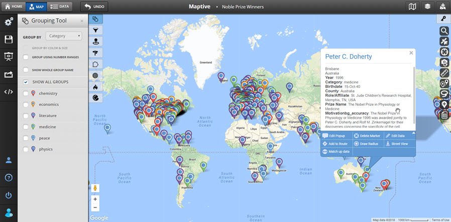
- Fully Customizable Maps: Control every single element on your map, add text, create icons, and manage the color and opacity of shapes.
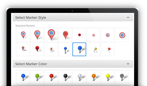
- Upload Custom Markers and Images: Customize your map and add markers with logos, store location photos, team photos, and more. Edit the style at any time.
- Support for Small or Large Data Sets: Upload data sets of any size, from less than 10 locations to 100,000+.
- Share, Print, and Embed Maps: Share your Google Map with your team or embed it on your website with one line of HTML code. Export your print layout even in poster size.
- Turn-by-Turn Navigation: Give your delivery crews and sales teams clear and easy-to-understand directions for each stop on their most efficient route.
- Enterprise-Level Security: Your data is protected with enterprise-level 256-bit encryption, two-factor authentication, backups, and disaster recovery.
- 100% Cloud-Based: Maptive is available on any device with an internet connection, including smartphones and tablets.
How Maptive Works: A Step-by-Step Guide
With Maptive’s intuitive platform, you can create a custom map in just a few easy steps:
Step 1. To start a new map, simply log into Maptive and click on the menu icon Create a Map.
Step 2. Open your Map Settings and explore custom styles from our templates or begin styling your Google Maps with objects, colors, and other settings as you prefer.
Step 3. Select Advanced Settings to enable, disable, or customize the appearance of any objects on your map, including roads, highways, landmarks, buildings, and more!
Step 4. Display your customized Google Maps in your presentation and document, embed it on your website, and enjoy the results!
Use Cases for Maptive
Delivery and Logistics: Maptive supports delivery and logistics companies to streamline operations and optimize delivery routes by mapping out customer locations and providing real-time traffic updates.
Sales and Marketing: Maptive helps sales and marketing teams to identify potential new target markets, analyze customer demographics, and optimize sales territories.
Real Estate: Maptive is vital for real estate agents as they map out properties, visualize market data, and analyze neighborhood demographics.
Healthcare: Maptive is crucial for healthcare providers who need to analyze patient data, visualize healthcare resources, and track healthcare trends across territories.
Government: Maptive helps local and state governments and public agencies who need to visualize population data, analyze emergency response times, and optimize public services.
Tourism and Hospitality: Maptive can help businesses embed custom tour maps on websites, show points of interest, and synch with real-time events and tourist activities updates.
What Our Customers Say About Us
See what others have to say about Maptive.

Affordable Pricing and Flexible Plans
- Start with Maptive’s FREE trial.
- Sign up for our basic plan for just $250 for a 45-day pass.
- Upgrade your plan at any time to add more users and advanced features.
Frequently Asked Questions
Sign Up for Maptive Today
Maptive can change the way you do business. Create a custom map, pick the styles you prefer, manage how elements and icons are displayed, and visualize what’s important to you and your bottom line.
All the custom styles you need to visualize your data. Zero coding required.
Start Your Free, No Risk, 10 Day Trial
No credit card required. No surprises. Just Results.


