


Why Google Maps Isn’t Enough for Sales Territory Planning
Google Maps succeeds at what it was designed to do: help people find directions, locate addresses, and plan simple routes. For a sales leader trying to divide a region into balanced territories, manage hundreds of accounts across multiple teams, optimize workload distribution, or track demographic alignment, Google Maps becomes a workaround rather than a solution.
The gap between basic navigation and professional territory planning is substantial. Sales teams that outgrow Google Maps do not simply face inconvenience. They face revenue leakage from unbalanced territories, wasted sales rep time, manual errors in account assignment, and the inability to respond quickly to market changes.
What Google Maps Does Well
Google Maps excels at visual location plotting. You can mark points on a map, search for addresses, and get driving directions. For a small team with a handful of accounts clustered in a single area, Google Maps My Maps offers a free or low-cost way to see customer locations on a map layer.
The tool requires no GIS training. Anyone with a Google account can start plotting data in minutes. This simplicity is its primary strength. For basic navigation and ad-hoc location reference, Google Maps remains practical.
The platform also integrates with various CRM systems through basic plugins and API connections. Pipedrive, Zoho CRM, and SuiteCRM can all pull customer addresses and display them on Google Maps, making it possible to visualize where prospects and customers are located without leaving the CRM interface.
Where Google Maps Falls Short
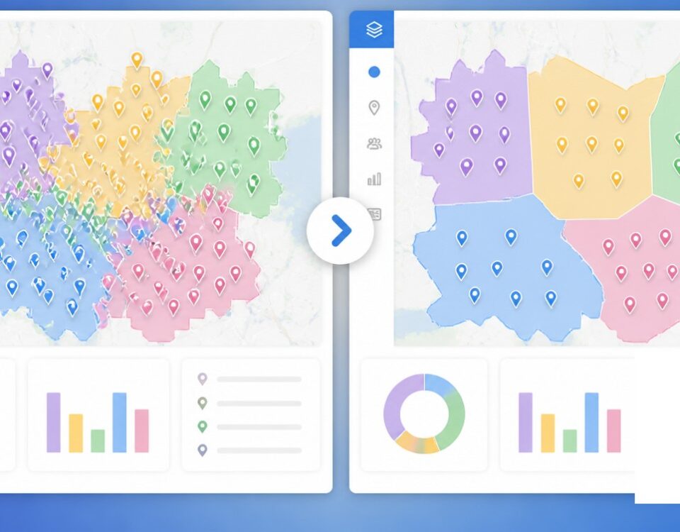
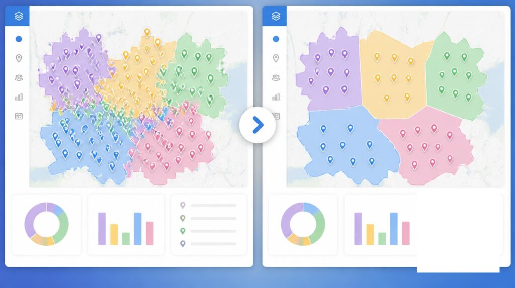
The limitations emerge quickly as territory complexity grows. Google My Maps enforces a hard limit of 2,000 data points per layer and supports only 10 layers per map. Once a sales team approaches these thresholds, the map interface slows, and managing overlapping account assignments becomes unwieldy.
Google Maps offers no native territory boundary creation. You cannot quickly define zip code territories, draw custom polygon boundaries, or assign multiple accounts to a single rep while ensuring balanced workload. Every territory must be created manually, point by point, with no system to verify that workload is distributed fairly across the team.
The tool has no demographic overlay capability. Sales leaders cannot see population density, income levels, age distribution, household counts, or business density overlaid on the map. These demographic factors directly impact territory viability. A dense urban territory with high income levels may contain more revenue opportunity than a rural territory with twice the land area.
Territory equity metrics do not exist in Google Maps. You cannot automatically balance territories by account count, revenue opportunity, travel time, or service frequency. If a rep’s territory includes 20 high-value enterprise accounts and another rep’s includes 100 small accounts, Google Maps provides no mechanism to adjust this imbalance. Sales leaders resort to manual spreadsheet tracking to measure workload, creating disconnected data and multiple sources of truth.
Google Maps lacks CRM integration depth. While basic address display is possible through plugins, you cannot sync territory assignments, track rep activity against territory boundaries, or move accounts between territories and see that change appear immediately in the CRM. The systems remain siloed.
Route optimization does not exist. Google Maps can show you a single route, but it cannot optimize a rep’s daily schedule by suggesting the most efficient sequence of customer visits. A rep must manually plan their route or rely on basic turn-by-turn navigation, wasting travel time.
Scenario modeling is impossible. A sales leader cannot test “what if I move this cluster of accounts to another rep” or “what if I realign based on travel time instead of account count.” Every change requires manual recalculation.
Key Gaps Compared to Purpose-Built Territory Mapping
| Feature | Google Maps | Territory Mapping Software |
|---|---|---|
| Territory boundary creation (zip codes, custom polygons) | No | Yes, automated and custom |
| Demographic overlays (population, income, business density) | No | Yes, multiple data sources |
| CRM integration | Basic address display only | Deep sync with territory assignments and activity tracking |
| Workload balancing (account count, revenue, travel time) | No | Yes, single-click optimization |
| Territory equity metrics | No | Yes, real-time reporting |
| Drive-time analysis (service area by minutes) | No | Yes, isochrone rings |
| Account reassignment workflow | Manual, disconnected | Automated, synced to CRM |
| Route optimization | Single route only | Multi-stop sequencing |
| Activity tracking by territory | No | Yes, location verification |
| Bulk data import from spreadsheets | Limited | Native, with validation |
| Data visualization layers | 10 layers max, 2,000 points | Unlimited layers and points |
| API for custom workflows | Limited | Full API for extensions |
The Cost of Manual Territory Planning
The financial case against Google Maps is compelling when you measure time and revenue impact. A manual territory realignment cycle using spreadsheets and Google Maps typically requires 4 to 8 weeks for sales operations teams to complete. With purpose-built territory mapping software, the same realignment can be done in 3 to 5 business days.
This time differential translates directly to lost selling productivity. If a sales team of 20 reps averages 5 hours per week spent on territory-related administrative work, manual planning costs $150,000 annually in recaptured selling time (calculating at $30/hour). When a territory is unbalanced, the highest-performing rep may be working with a disadvantaged territory while an average performer has an exceptional territory. This mismatch alone suppresses overall team revenue.
Manual territory assignment also increases error rates. Spreadsheet-based tracking means multiple versions of truth. A rep may not realize they have been assigned a new account because the assignment lives in an email or spreadsheet rather than in the CRM. Account ownership disputes arise. Overlapping territory assignments go undetected until multiple reps contact the same prospect.
Territory imbalance compounds these issues. When reps have unequal workload, retention suffers. High-performing reps with disadvantaged territories leave for competitors. Low-performing reps in excellent territories create false confidence in hiring decisions. Research from McKinsey shows that proper territory realignment correlates with 2-7% revenue uplift without additional headcount. Poor alignment actively suppresses revenue.
When Sales Teams Outgrow Google Maps
Most sales teams begin using Google Maps casually. A few scattered customer locations are plotted. It works fine. But as the team grows, Google Maps quickly becomes insufficient. The transition typically happens at specific inflection points.
- Team size. A sales rep with 50 accounts can manage basic plotting in Google Maps. A team of 5 reps with 250 accounts cannot. The administrative overhead of manually managing points becomes unmanageable. What should be strategy work becomes territory administration.
- Territory complexity. If all accounts are within a single zip code, Google Maps handles the visualization. If territories span multiple states or counties, manual polygon drawing in Google Maps becomes tedious and error-prone. You cannot quickly redraw a boundary by moving a rep’s service area from zip code X to zip code Y.
- Data volume. As data points grow beyond 500 or 1,000, the map interface slows. Performance degradation is noticeable.
- Frequency of realignment. If the team realigns territories once per year, the time invested in manual spreadsheet work is acceptable. If realignment happens quarterly, the burden becomes prohibitive.
- Demographic factors. Once a sales leader needs to consider account count alongside income levels, business density, and population data, Google Maps is no longer viable. These overlays require specialized GIS-capable mapping tools.
- Multi-layer visualization. If a sales leader needs to see customers, prospects, competitor locations, and service areas all at once, Google Maps’ 10-layer limit becomes restrictive.
- CRM integration requirements. The moment the sales leader wants territory assignments to sync automatically with Salesforce, HubSpot, or Pipedrive, basic Google Maps integration is insufficient. Territory changes must flow seamlessly from the mapping tool into the CRM.
How Purpose-Built Territory Mapping Works Differently
Maptive begins with the same geographic foundation as Google Maps but adds layers designed specifically for sales operations.
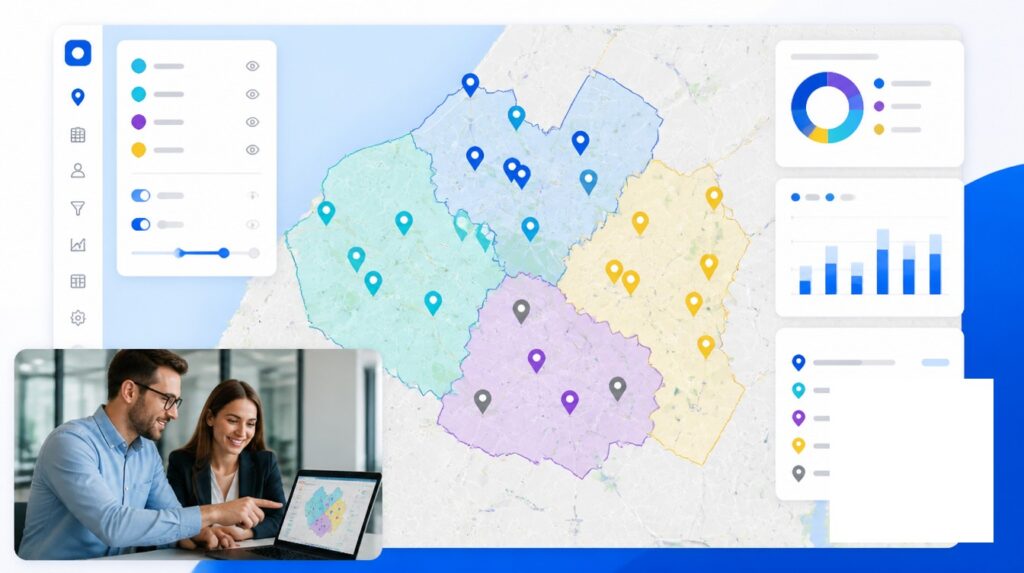
Account import is bulk and automated. Instead of plotting 250 accounts by hand, you upload a CSV file or sync directly from your CRM. The system geocodes addresses automatically, detects duplicates, and flags data quality issues.
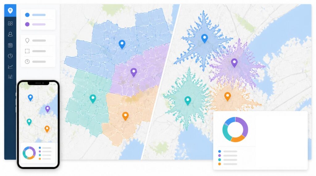
Territory creation uses standard boundaries or custom drawing. You can select zip codes, counties, or sales districts from built-in databases, or draw custom polygons by clicking map coordinates. The platform manages overlaps, ensuring no account belongs to multiple territories simultaneously.
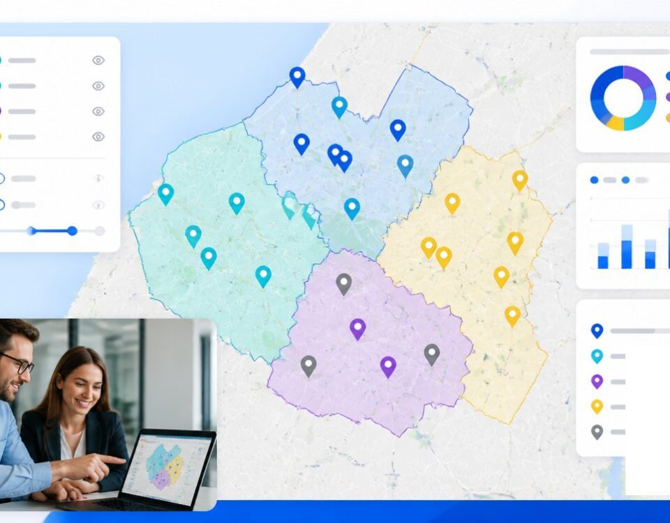
Demographic data is native. Population, income, age, business count, and industry classification are layered in automatically. You see where accounts are and what market opportunity each area represents.
Workload balancing is algorithmic. The system can optimize territories simultaneously across your entire team, adjusting boundaries to balance by account count, revenue potential, travel time, or a weighted combination. A single click rebalances a territory that was manually adjusted ad hoc. Changes are instantly applied to the CRM.
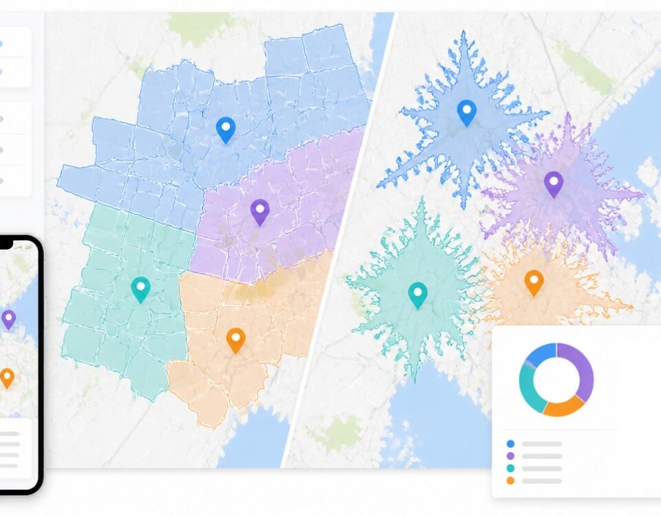
Drive-time analysis shows service coverage. Instead of plotting an account location as a single point, the system draws an isochrone ring around each territory showing the area reachable by a specified drive time (5 minutes, 10 minutes, 30 minutes). This reveals coverage gaps and helps align territory boundaries with actual travel feasibility.
Activity tracking is automatic. As sales reps move through their territories, location data is verified. You can see which accounts received visits, which were skipped, and where time was spent. This activity feeds back into territory optimization. If a rep is consistently traveling outside their assigned territory to reach accounts, the territory boundary may need adjustment.
CRM synchronization is bidirectional. Change a territory in the mapping platform, and the CRM updates in real time. Add a new account in Salesforce, and it appears on the territory map automatically.
Scenario modeling allows what-if analysis. You can test a new territory alignment without committing to it. See how revenue distribution changes if you reassign a cluster of accounts. See how travel time changes if you redraw a boundary. The platform shows the impact before the change goes live.
The Gap Between Free and Fit-for-Purpose
Google Maps is genuinely free. Purpose-built territory mapping tools require budget. Entry-level territory mapping software costs $250 to $2,500 per year, or $49 to $75 per user per month for more advanced features.
The comparison is not cost versus free. It is tool cost versus the cost of the problems it prevents. A sales team that spends 20 hours per week on manual territory administration is already paying the equivalent of a full-time salary for inefficiency. A tool that eliminates half that work pays for itself within months.
Maptive and other territory mapping platforms justify their cost through time savings, revenue alignment, and data accuracy. The tool does not replace judgment. A sales leader still decides the strategy. But it eliminates the tedious administration that consumes strategy time.
Why Accuracy Matters More Than Convenience
Google Maps is convenient. You can plot a point in seconds. Convenience, however, is not the same as accuracy or capability.
An unbalanced territory does not stay unbalanced silently. It creates rep burnout, revenue loss, and high turnover. A territory boundary that was hand-drawn without demographic consideration may exclude a high-value area or include areas the rep cannot reach in a single day.
Territory planning is infrastructure. Poor infrastructure is expensive. It looks cheap upfront because you are not paying for a tool. But you are paying in rep time, administrative overhead, and missed revenue.
Purpose-built territory mapping software is designed specifically to solve this class of problem. It does not ask you to adapt your approach to a navigation tool. It adapts to your territory planning needs.
The choice is not between Google Maps and some theoretical ideal. It is between a free tool designed for a different purpose and a purpose-built tool designed for exactly what you are trying to do. For sales teams with more than a handful of territories, the latter is simply the better investment.


